Gazetteer of Scotland > Volume 1
(239) Page 211
Download files
Complete book:
Individual page:
Thumbnail gallery: Grid view | List view

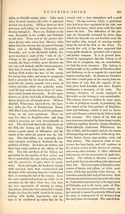
DUMFRIBS-SIIIRE.
211
miles, or 785,920 statute acres. Like many-
Other Scottish counties, the shire is popularly
divided into districts. Of these there are three
principal, each taking its name from the river
flowing through it. These are, Eskdale on the
east, Annandale in the middle, and Nithsdale
on the west. From each of the greater divi-
sions diverge vales which have likewise titles
taken from the streams that are poured through
them, such as Moffatdale, Dryfesdale, and
Ewesdale, and in the old border ballads, fre-
quent mention is made of the " lads of Ae."
Owing to the generally level nature of the
country, the limits of those great divisions are
not very well defined, and for certain purposes,
they have in recent times been altered. The
Sol way Firth washes the base of the county
for twenty-four miles, and along its margin the
land is generally flat for about ten miles. Be-
yond this the country expands into a series of
valleys and hills, which rise gradually north-
ward till they reach the above chain of moun-
tains which bounds the county. In this upper
district are all the chief hills of Dumfries-shire,
whose heights are afterwards given. Of these
Hartfell, Whitecoom, Queensberry, the Low-
ther Hills, the Pen of Eskdalemuir, Tinnis
Hill, Black Larg, Gallaberry, and Glenquhargen
Craig, are the most prominent. There are
very few lakes in Dumfries-shire, and those
which it possesses are very inconsiderable in
size. The chief and almost the only rivers are
the Nith, the Annan, and the Esk. These
receive a great variety of tributaries, and the
waters of the whole are poured into the Sol-
way. This firth differs very materially from
other estuaries receiving in Scotland the ap-
pellation of firths. Its waters are shallow, and
leave long sandy reaches at the ebbing of the
tide. The ebbs and flows of the Sol way are
proverbial for the rapidity of their action, and
this is particularly the case during spring tides,
and the prevalence of gales from the south-
west. Again and again, the borderers, though
well mounted, have been overwhelmed and
drowned while returning from the Cumberland
fairs, in crossing the bed of the estuary. Even
the most experienced persons are liable to be
overtaken by the tides, when they may have
the best expectation of crossing in safety.
Sometimes, when they have proceeded a certain
length, they hear the awful sound of the waters,
rushing with fearful impetuosity, and are
sure to be swallowed up unless they be fa-
voured with a clear atmosphere and a good
horse. On one occasion lately, a gentleman
who had been thus engulphed in the tide, was
saved by his horse, which swam with him right
across the firth. The difficulties of the pas-
sage are frequently increased by dense fogs,
which rise from the sea and bewilder even the
best guides, who, instead of crossing, wander
along the bed of the Esk or the Eden. To
remedy this evil, it has been suggested that
every guide should be provided with a lantern
and pocket compass. It is in general men-
tioned by topographers that the Solway is of
little use in navigation, but, on examination,
we find this to be incorrect. The Solway is
indispensable to the welfare of Dumfries-shire
and Galloway, so far as regards the export and
import coasting trade. So distant are Dumfries
and other central parts of the country from na-
tive mines of coal, that the expense of car-
riage gives Lord Lonsdale and other English
coalmasters a monopoly of the trade. The
tonnage, therefore, of vessels employed in
this traffic on the Solway, is very considerable.
The estuary, however shallow in some parts,
is also of prodigious benefit in permitting the
free export of the farm produce of Dumfries-
shire and Galloway, which is sent to Liver-
pool and Glasgow entirely by the Solway in the
first instance. The waters of the firth are
now, moreover, ploughed by three steam vessels,
which ply regularly between Annan, Dumfries,
Kirkcudbright, Garlieston, Whitehaven, the
Isle of Man, and Liverpool, and are the means
of transporting vast quantities of fat sheep, bid-
locks, butter, cheese, eggs, poultry, wool, and
other articles. This improved mode of con-
veyance has been lately, and will continue to
be, of great service to this district of country,
and among other benefits, it offers additional
inducements for tiie prosecution of spade hus-
bandry. The Solway is likewise a source of
much profit from its abounding with salmon and
other fish. The lower parts of Dumfries-shire
consist of brown, red, yellow, or white sand-
stone, which dips generally to the Solway. It
contains a considerable body of limestone. Beds
of ironstone sometimes accompany the other stra-
ta. Coal exists in great plenty in the upper parta
of Nithsdale, and in the lower parts of Esk-
dale, the two extreme points of the county. As
just noticed, it cannot be generally diffused ov«
the shire, in consequence of its distance front
the chief place of consumpt. The coal of Esk*
Set display mode to: Large image | Transcription
Images and transcriptions on this page, including medium image downloads, may be used under the Creative Commons Attribution 4.0 International Licence unless otherwise stated. ![]()
| Gazetteers of Scotland, 1803-1901 > Gazetteer of Scotland > Volume 1 > (239) Page 211 |
|---|
| Permanent URL | https://digital.nls.uk/97427230 |
|---|
| Description | Volume I: Abbey to Glenartney. |
|---|---|
| Attribution and copyright: |
|
| Description | By Robert Chambers and William Chambers. Glasgow: Blackie & Son, 1838. 2 volumes. |
|---|---|
| Shelfmark | NF.1461.g.7 |
| Additional NLS resources: | |

