Gazetteer of Scotland > Volume 1
(222) Page 194 - DOR
Download files
Complete book:
Individual page:
Thumbnail gallery: Grid view | List view

194
DOUGLAS.
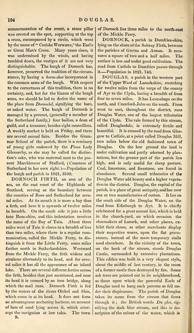
commemoration of the event, a stone pillar
was erected on the spot, supporting at the top
a cross, encompassed by a circle, which went
by the name of" CroiskeWorwarre," the Earl's
or Great Man's Cross. Many years since, it
was undermined by the winds, and having
tumbled down, the vestiges of it are not very
distinguishable. The burgh of Dornoch has,
however, preserved the tradition of the circum-
stance, by having a horse-shoe incorporated in
the common arms of the burgh. With respect
to the correctness of this tradition, there is no
certainty, and, but for the blazon of the burgh
arms, we should be led to derive the name of
the place from Dornochd, signifying the bare,
or naked water. The burgh of Dornoch is
managed by a provost, (generally a member of
the Sutherland family,) four bailies, a dean of
guild, and a treasurer, besides eight councillors.
A weekly market is held on Friday, and there
are several annual fairs. Besides the Gram-
mar School of the parish, there is a seminary
of young girls endowed by the Pious Lady
Glenorchy, as she may be called for distinc-
tion's sake, who was maternal aunt to the pre-
sent Marchioness of Stafford, (Countess of
Sutherland in her own right. ) — Population of
the burgh and parish in 1821, 3100.
DORNOCH FIRTH, an arm of the
sea, on the east coast of the Highlands of
Scotland, serving as the boundary between
the counties of Ross and Sutherland for seve-
ral miles. At its mouth it is more a bay than
a firth, and here it is upwards of twelve miles
in breadth. On the south side it juts a little
into Ross-shire, and this indentation receives
the name of the Bay of Tain. About three
miles west of Tain it closes to a breadth of less
than two miles, where there is a regular com-
munication, called the Mickle Ferry, to dis-
tinguish it from the Little Ferry, some miles
farther north in Sutherlandshire. Westward
from the Mickle Ferry, the firth widens and
straitens alternately to its head, and for seve-
ral miles it has all the appearance of an inland
lake. There are several different ferries across
the firth, besides that just mentioned, and near
its head it is crossed by an iron bridge, along
which the mail runs. Dornoch Firth is fed
by the waters of the rivers Oickel and Shin,
which come in at its head. Tt does not form
an advantageous anchoring harbour, on account
of bars of sand lying across it, which inter-
cept the navigation at low tides. The town
of Dornoch lies three miles to the north-east
of the Mickle Ferry.
DORNOCK, a parish in Dumfries-shire,
lying on the shore of the Solway Firth, between
the parishes of Gretna and Annan. It mea-
sures a square of two and a half miles. The
surface is low and under good cultivation. The
road from Carlisle to Dumfries passes through
it — Population in 1821, 743.
DOUGLAS, a parish in the western part
of the Upper Ward of Lanarkshire, stretching
for twelve miles from the verge of the county
of Ayr to the Clyde, having a breadth of from
four to seven miles. It has Lesmahago on the
north, and Crawford- John on the south. From
west to east, throughout the district, runs
Douglas Water, one of the largest tributaries
of the Clyde. The vale formed by this stream,
called Douglasdale, is extremely fertile and
beautiful. It is crossed by the road from Glas-
gow to Carlisle, at a point called Douglas Mill,
two miles below the old fashioned town of
Douglas. On the low ground the land is
under cultivation and partly adorned by plan-
tations, but the greater part of the parish lies
high, and is only useful for sheep pasture.
Coal, limestone, and freestone, are found in
abundance. Several small tributaries of the
Douglas Water add beauty and a higher vegeta-
tion to the district. Douglas, the capital of the
parish, is a place of great antiquity, and has now
one or two manufactories of cotton. It lies on
the south side of the Douglas Water, on the
road from Edinburgh to Ayr. It is chiefly
celebrated for a great annual fair, which is held
in the church-yard, on which occasion the
shoemakers of Lanark, and other places, ex-
hibit their shoes, as other merchants display
their respective wares, upon the flat grave-
stones, instead of the more temporary stalls
used elsewhere. In the vicinity of the town,
on the bank of the stream, stands Douglas
Castle, surrounded by extensive plantations.
This edifice was built in a very elegant style,
about the middle of last century, in the room
of a former castle then destroyed by fire. Some
ash trees are pointed out in its neighbourhood,
as those upon which the powerful Earls of
Douglas used to hang such persons as fell un-
der their displeasure. The parish of Douglas
takes its name from the stream that flows
through it ; the British words JDu glas, sig-
nifying the dark blue stream, and this is de-
scriptive of the colour of the water, which is
Set display mode to: Large image | Transcription
Images and transcriptions on this page, including medium image downloads, may be used under the Creative Commons Attribution 4.0 International Licence unless otherwise stated. ![]()
| Gazetteers of Scotland, 1803-1901 > Gazetteer of Scotland > Volume 1 > (222) Page 194 - DOR |
|---|
| Permanent URL | https://digital.nls.uk/97427026 |
|---|
| Description | Volume I: Abbey to Glenartney. |
|---|---|
| Attribution and copyright: |
|
| Description | By Robert Chambers and William Chambers. Glasgow: Blackie & Son, 1838. 2 volumes. |
|---|---|
| Shelfmark | NF.1461.g.7 |
| Additional NLS resources: | |

