Gazetteer of Scotland > Volume 1
(185) Page 157
Download files
Complete book:
Individual page:
Thumbnail gallery: Grid view | List view

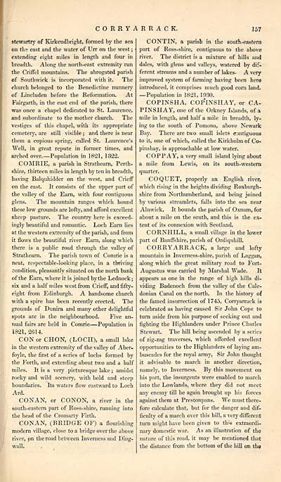
CORRYARRACK.
157
stewartry of Kirkcudbriglit, formed by the sea
on the east and the water of Urr on the west ;
extending eight miles in length and four in
breadth. Along the north-east extremity run
the Criffel mountains. The abrogated parish
of Southwick is incorporated with it. The
church belonged to the Benedictine nunnery
of Lincluden before the Reformation. At
Fairgarth, in the east end of the parish, there
was once a chapel dedicated to St. Laurence,
and subordinate to the mother church. The
vestiges of this chapel,, with its appropriate
cemetery, are still visible ; and there is near
them a copious spring, called St. Laurence's
Well, in great repute in former times, and
arched over. — Popidation in 1821, 1322.
COMRIE, a parish in Strathearn, Perth-
shire, thirteen miles in length by ten in breadth,
having Balquhidder on the west, and Crieff
on the east. It consists of the upper part of
the valley of the Earn, with four contiguous
glens. The mountain ranges which bound
these low grounds are lofty, and afford excellent
sheep pasture. The country here is exceed-
ingly beautifid and romantic. Loch Earn lies
at the western extremity of the parish, and from
it flows the beautiful river Earn, along which
there is a public road through the valley of
Strathearn. The parish town of Comrie is a
neat, respectable-looking place, in a thriving
condition, pleasantly situated on the north bank
of the Earn, where it is joined by the Lednock;
six and a half miles west from Crieff, and fifty-
eight from Edinburgh. A handsome church
with a spire has been recently erected. The
grounds of Dunira and many other delightful
spots are in the neighbourhood. Five an-
nual fairs are held in Comrie — Population in
1321, 2614.
CON or CHON, (LOCH), a small lake
in the western extremity of the valley of Aber-
foyle, the first of a series of lochs formed by
the Forth, and extending about two and a half
miles. It is a very picturesque lake ; amidst
rocky and wild scenery, with bold and steep
boundaries. Its waters flow eastward to Loch
Ard.
CONAN, or CONON, a river in the
south-eastern part of Ross-shire, running into
the head of the Cromarty Firth.
CONAN, (BRIDGE OF) a flourishing
modern village, close to a bridge over the above
river, on the road between Inverness and Ding-
wall. '
CONTIN, a parish in the south-eastern
part of Ross-shire, contiguous to the above
river. The district is a mixture of hills and
dales, with glens and valleys, watered by dif-
ferent streams and a number of lakes. A very
improved system of farming having been here
introduced, it comprises much good com land.
—Population in 1821, 1930.
COPINSHA, COPINSHAY, or CA-
PINSHAY, one of the Orkney Islands, of a
mile in length, and half a mile in breadth, ly-
ing to the south of Pomona, above Newark
Bay. There are two small islets contiguous
to it, one of which, called the Kirkholm of Co-
pinshay, is approachable at low water.
COPPAY, a very small island lying about
a mile from Lewis, on its south-western
quarter.
COQUET, properly an English river,
which rising in the heights dividing Roxburgh-
shire from Northumberland, and being joined
by various streamlets, falls into the sea near
Alnwick. It bounds the parish of Oxnam, for
about a mile on the south, and this is the ex-
tent of its connexion with Scotland.
CORNHILL, a small village in the lower
part of Banffshire, parish of Ordiquhill.
CORRYARRACK, a large and lofty
mountain in Inverness-shire, parish of Laggan,
along which the great military road to Fort-
Augustus was carried by Marshal Wade. It
appears as one in the range of high hills di-
viding Badenoch from the valley of the Cale-
donian Canal on the north. In the history of
the famed insurrection of 1745, Corryarrack is
celebrated as having caused Sir John Cope to
turn aside from his purpose of seeking out and
fighting the Highlanders under Prince Charles
Stewart. The hill being ascended by a series
of zig-zag traverses, which afforded excellent
opportunities to the Highlanders of laying am-
buscades for the royal army, Sir John thought
it advisable to march in another direction,
namely, to Inverness. By this movement on
his part, the insurgents were enabled to march
into the Lowlands, where they did not meet
any enemy till he again brought up his forces
against them at Prestonpans. We must there-
fore calculate that, but for the danger and dif-
ficulty of a march over this hill, a very different
turn might have been given to this extraordi-
nary domestic war. As an illustration of the
nature of this road, it may be mentioned that
the distance from the bottom of the hill on tha
Set display mode to: Large image | Transcription
Images and transcriptions on this page, including medium image downloads, may be used under the Creative Commons Attribution 4.0 International Licence unless otherwise stated. ![]()
| Gazetteers of Scotland, 1803-1901 > Gazetteer of Scotland > Volume 1 > (185) Page 157 |
|---|
| Permanent URL | https://digital.nls.uk/97426582 |
|---|
| Description | Volume I: Abbey to Glenartney. |
|---|---|
| Attribution and copyright: |
|
| Description | By Robert Chambers and William Chambers. Glasgow: Blackie & Son, 1838. 2 volumes. |
|---|---|
| Shelfmark | NF.1461.g.7 |
| Additional NLS resources: | |

