Gazetteer of Scotland > Volume 1
(13) Page v
Download files
Complete book:
Individual page:
Thumbnail gallery: Grid view | List view
INTRODUCTION. v
albin, or " Great glen of Caledonia, 11 stretching from Loch Linnhe to
the Moray firth, now connected together by the Caledonian canal. The
middle division is separated from the southern by the firths of Forth and
Clyde, now united by the Great canal.
In the northern division little is to be seen but a vast congeries of lofty
mountains ; these hills are bordered however on the north-east and east coasts
by level tracts of considerable fertility — this physically low country, though
politically included in the Highland district, forms a tract ranging from In-
verness, along the sea-shore as far south as Aberdeen or Stonehaven, where
it terminates for a short space to be again renewed on a broader scale. The
tract, indeed, which commencing by an eastern margin, extends hence to the
Lammermoor range southwards, and then crosses westward to Glasgow, may
be esteemed the proper lowland tract of Scotland, though even this affords
little continuous plain country, being everywhere interspersed with or inter-
rupted by ridges.
Of the two distinct tracts of mountain land or high country, the north-
western forms the district of the Highlands above traced out and minutely
described under this title in the alphabetical arrangement. The southern
comprises the great pastoral district or dales, the former seat of those bor-
derers who resembled the Highlanders in their predatory habits, and main-
tained an almost perpetual warfare with England. Its boundary is less dis-
tinctly marked than the northern, but generally it may be conceived to com-
mence on the east with the Lammermoor ridge, and passing along the Pent-
lands, Tinto, &c, to terminate near Creetown in Galloway ; it thus leaves a
considerable tract of irregular low country to the westward.
The particular physical properties of the subdivisions of these great dis-
tricts as well as their agricultural and statistical condition, are sufficiently
described in the body of this work ; it remains only to show connectedly their
relative proportions to each other, and the extent of the whole country.
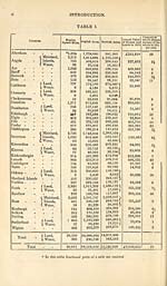
The following table, constructed from Arrowsmith 1 s large map of Scotland
by Mr. Jardine and Sir George Mackenzie, enables us to present the nearest
approximation to the truth on this point which has yet appeared, and con-
sidering the care taken, and the scientific character of these gentlemen, per-
haps as close an approach to it as the data will allow.
To this table we have added the annual value of houses and lands, (in-
cluding mines, fisheries &c.) as assessed for the property tax in 1815, col-
lected from the county returns, published in the parliamentary paper, " Re-
sults of the Census of 1831," just printed, and also a column from Sir J. Sin-
clair's General Report, showing what proportion of the annual value in 1811
was derived from houses, the rest being land, mines, fisheries, &c.
The term water in the table is understood to indicate only the fresh water
of considerable lochs, that of rivers, salt water, and firths not being included.
We need scarcely add that the actual superficies of any country, more
especially of such a hilly country as Scotland, must considerably exceed the
result obtained by a mode of measurement which proceeds on the supposition
that the whole is a flat plain surface. The surface presented by a hill must
evidently always exceed the superficies of the area on which it stands.
albin, or " Great glen of Caledonia, 11 stretching from Loch Linnhe to
the Moray firth, now connected together by the Caledonian canal. The
middle division is separated from the southern by the firths of Forth and
Clyde, now united by the Great canal.
In the northern division little is to be seen but a vast congeries of lofty
mountains ; these hills are bordered however on the north-east and east coasts
by level tracts of considerable fertility — this physically low country, though
politically included in the Highland district, forms a tract ranging from In-
verness, along the sea-shore as far south as Aberdeen or Stonehaven, where
it terminates for a short space to be again renewed on a broader scale. The
tract, indeed, which commencing by an eastern margin, extends hence to the
Lammermoor range southwards, and then crosses westward to Glasgow, may
be esteemed the proper lowland tract of Scotland, though even this affords
little continuous plain country, being everywhere interspersed with or inter-
rupted by ridges.
Of the two distinct tracts of mountain land or high country, the north-
western forms the district of the Highlands above traced out and minutely
described under this title in the alphabetical arrangement. The southern
comprises the great pastoral district or dales, the former seat of those bor-
derers who resembled the Highlanders in their predatory habits, and main-
tained an almost perpetual warfare with England. Its boundary is less dis-
tinctly marked than the northern, but generally it may be conceived to com-
mence on the east with the Lammermoor ridge, and passing along the Pent-
lands, Tinto, &c, to terminate near Creetown in Galloway ; it thus leaves a
considerable tract of irregular low country to the westward.
The particular physical properties of the subdivisions of these great dis-
tricts as well as their agricultural and statistical condition, are sufficiently
described in the body of this work ; it remains only to show connectedly their
relative proportions to each other, and the extent of the whole country.
The following table, constructed from Arrowsmith 1 s large map of Scotland
by Mr. Jardine and Sir George Mackenzie, enables us to present the nearest
approximation to the truth on this point which has yet appeared, and con-
sidering the care taken, and the scientific character of these gentlemen, per-
haps as close an approach to it as the data will allow.
To this table we have added the annual value of houses and lands, (in-
cluding mines, fisheries &c.) as assessed for the property tax in 1815, col-
lected from the county returns, published in the parliamentary paper, " Re-
sults of the Census of 1831," just printed, and also a column from Sir J. Sin-
clair's General Report, showing what proportion of the annual value in 1811
was derived from houses, the rest being land, mines, fisheries, &c.
The term water in the table is understood to indicate only the fresh water
of considerable lochs, that of rivers, salt water, and firths not being included.
We need scarcely add that the actual superficies of any country, more
especially of such a hilly country as Scotland, must considerably exceed the
result obtained by a mode of measurement which proceeds on the supposition
that the whole is a flat plain surface. The surface presented by a hill must
evidently always exceed the superficies of the area on which it stands.
Set display mode to: Large image | Transcription
Images and transcriptions on this page, including medium image downloads, may be used under the Creative Commons Attribution 4.0 International Licence unless otherwise stated. ![]()
| Gazetteers of Scotland, 1803-1901 > Gazetteer of Scotland > Volume 1 > (13) Page v |
|---|
| Permanent URL | https://digital.nls.uk/97424518 |
|---|
| Description | Volume I: Abbey to Glenartney. |
|---|---|
| Attribution and copyright: |
|
| Description | By Robert Chambers and William Chambers. Glasgow: Blackie & Son, 1838. 2 volumes. |
|---|---|
| Shelfmark | NF.1461.g.7 |
| Additional NLS resources: | |
| Description | 20 volumes of the most popular descriptive gazetteers of Scotland, providing a comprehensive geographical encyclopaedia of Scotland in the 19th century. Principal places in Scotland, including towns, counties, castles, glens, antiquities and parishes, are listed alphabetically. Each entry includes detailed historical and geographical information about each place. |
|---|---|