Gazetteer of Scotland
(151) Page 149
Download files
Complete book:
Individual page:
Thumbnail gallery: Grid view | List view

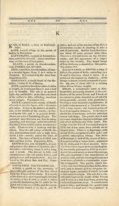
KAIL, or KALE, a river in Roxburgh-
shire.
KAIM, a small village in the parish of
Duffus in Morayshire.
KATTERLINE, a parish in Kincardine,
shire, united to Kinneff'. Also a small har-
bour on the coast of that parish.
KEARN, a parish in Aberdeenshire.
Vide FORBES and KEARN.
KEIG, a parish in Aberdeenshire, of near-
ly a circular figure, from 3 to 4 miles in
diameter. It is watered by the river Don.
Population 465.
KEILLESAY, a small island of the He-
brides, 5 miles N. E. of Barray.
KEIR, a parish in D umfries-shire, S miles
in length, on an average from 2 and a half
io3 in breadth. The soil is in general
light, dry, and fertile; more than one third
of the surface is hilly, affording excellent
sheep-pasture. Population 993.
KEITH, a parish in the county of Banff,
of nearly a circular figure, with a diameter
of 6 miles. It lies in the district of Strath-
isla, in the middle of the county ; is wat-
ered by the Isla, and is is general fertile.
There are several flourishing villages. The
principal manufactures are flax-dressing,
spinning, and weaving ; and a bleachfield
has lately been established on an extensive
scale. There are also a tannery and dis-
tillery. Near the old village of Keith, the
Isla, precipitating itself over a high rock,
forms a line cascade, called the Linn of
Keith. The town of Keith is divided into
Old and New Keith. Population 3352.
KEITH-HALL and KINKELL, an uni-
ted parish in the district of Garioch, Aber-
deenshire, extending about 6 miles long,
and 5 broad. The district is hilly and
mountainous; the soil partly fertile, and
partly barren and unproductive. It is wa-
tered by the risers Don and Dry. Popu-
lation SS3.
- KEITH-INCH. Vide PETERHEAD.
KELLS, a parish in the stewartry of
-Kirkcudbright, and one of the four which
form the district of Glenkens. It is nearly
of the form of an isosceles triangle, the base
of which, at the N. end, is about 6 miles,
gradually diminishing for 15 mile3 to the
point where the river of Dee and Ken unite.
These rivers bound it on the E. and W.
sides ; and one of the streams of the Ken is
its boundary on the N. forming it into a
sort of peninsula. Besides Loch Ken there
are about 80 acres covered with lakes.
There is a rich lead mine on the Glenlee
estate, and the appearance of a copper
mine in the vicinity. The Royal burgh
of New Galloway is situated in this parish.
Population 941.
KELLS RANGE, or RH YNS, a ridge of
hills in the parish of Kells, extending in a
N. and S. direction about 8 miles. It is
reckoned the highest in Galloway. Kells
Range is almost entirely composed of gran-
ite. On, one of these hills is a rocking
stone of 8 or 10 tons weight.
KELSO, a considerable town in Rox-
burghshire, pleasantly situated at the con-
fluence of the rivers Teviot and Tweed, on
an extensive plain, bounded on all sides by
rising grounds, covered with plantations,
forming a most beautiful amphitheatre. It
is built in the manner of a Flemish town,
with a large square, and 6 streets going oil*
from it at regular distances. In the square
stands the town-house, with the principal
houses and shops. The parish church and
episcopal chapel are elegant buildings, and
add much to the beauty of the town. The
bridge over the Tweed was carried away in
17 l )8, but it has since been rebuilt on an
elegant plan. There is a dispensary, with
rooms for the reception of a few sick ; and
a public subscription library. The Duke
of Roxburgh is lord of the. manor of Kelso.
It is governed by a baron-bailie, appointed
by the Duke, and 1 5 stent masters. Kelso
was three times burnt down by the English.
It was totally destroyed in lGSG by an acci-
dental fire; and nearly so about 90 years ago.
The principal trade is the manufacture of
woollen cloth, and the dressing of sheep and
lambskins, of which a considerable quan-
tity is exported. The parish, which for-
merly contained three parishes, Kelso, Max.
well, and St James', is of an irregular tri-
angular figure, each side of which is 4 and
a half miles in length. The soil, for a con-
siderable tract on the banks of the Tweed
and Teviot, is a rich deep loam, producing
early and luxuriant crops. A considerable
part is iiilly ; and though the greater part
is arable, it is kept under sheep pasture. A
Set display mode to: Large image | Transcription
Images and transcriptions on this page, including medium image downloads, may be used under the Creative Commons Attribution 4.0 International Licence unless otherwise stated. ![]()
| Gazetteers of Scotland, 1803-1901 > Gazetteer of Scotland > (151) Page 149 |
|---|
| Permanent URL | https://digital.nls.uk/97423506 |
|---|

