Ordnance gazetteer of Scotland
(1467) Page 1459
Download files
Complete book:
Individual page:
Thumbnail gallery: Grid view | List view

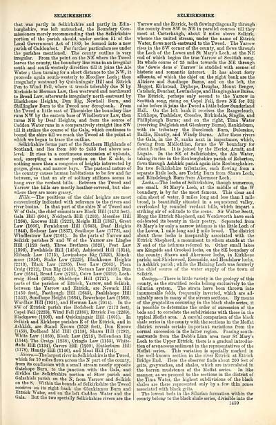
SELKIRKSHIRE
that was partly in Selkirkshire and partly in Edin-
burghshire, was left untouched, the Boundary Com-
missioners merely recommending that the Selkirkshire
portion of the parish should, under section 51 of the
Local Government Act of 18S9, be formed into a new
parish of Caddonfoot. For further particulars see under
the parishes mentioned. The county outline is very
irregular. From the point on the NE where the Tweed
leaves the county, the boundary line runs in an irregular
south and south-westerly direction till it joins the Ale
"Water ; then turning for a short distance to the NW, it
proceeds again south-westerly to Moodlaw Loch ; then
irregularly westward by Quickningair Hill and Ettrick
Pen to Wind Fell, where it trends tolerably due N by
Mirkside to Herman Law, then westward and northward
to Broad Law, afterwards irregularly north-eastward by
Blackhouse Heights, Dun Rig, Newhall Burn, and
Shillinglaw Burn to the Tweed near Scrogbank. From
the Tweed a little east of Thornielee the boundary line
runs NW by the eastern base of Windlestraw Law, then
turns NE by Deaf Heights, and from the source of
Caddon Water runs in a comparatively straight line SW
till it strikes the course of the Gala, which continues to
bound the shire till we reach the Tweed at the point at
which we began to trace the outline.
Selkirkshire forms part of the Southern Highlands of
Scotland, and lies from 300 to 2433 feet above sea-
leveL It rises in a continuous succession of uplands,
and, excepting a narrow portion on the E side, is
nothing more than a congeries of heights intersected by
gorges, glens, and narrow bays. The pastoral nature of
the country causes human habitations to be few and far
between, so that an air of solitary stillness seems to
hang over the verdant hills. Between the Tweed and
Yarrow the hills are mostly heather-covered, but else-
where they are more grassy.
Hills. — The positions of the chief heights are most
conveniently indicated with reference to the rivers and
river basins. In that part of the shire N of Tweed and
W of Gala, the chief summits are Black Hill (1473 feet),
Gala Hill (904), Neidpath Hill (1203), Mossilee Hill
(1264), Knowes Hill (1222), Meigle Hill (1387), Great
Law (1666), Ferniehurst Hill (1643), Deaf Heights
(1844), Redscar Law (1837), Seathope Law (1778), and
Windlestraw Law (2161). In the parts of Yarrow and
Selkirk parishes N and W of the Yarrow are Linglee
Hill (1123 feet), Three Brethren (1523), Peat Law
(1396), Fowlshiels Hill (1454), Ashiesteil Hill (1314),
Elibank Law (1715), Lewinshope Rig (1320), Minch-
moor (1856), Stake Law (2229), Blackhouse Heights
(2213), Black Law (2285), Deer Law (2065), Flora
Craig (1212), Dun Rig (2433), Notnan Law (2408), Dun
Law (2584), Broad Law (2723), Cairn Law (2352), Loch-
craig Head (2625), Shielhope Hill (1727). In the
parts of the parishes of Ettrick, Yarrow, and Selkirk,
between the Yarrow and Ettrick, are Newark Hill
(1450 feet), Fastheugh Hill (1645), Fauldshope Hill
(1532), Sundhope Height (1684), Bowerhope Law (1569),
Wardlaw Hill (1951), and Herman Law (2014). In the
SW of Ettrick parish rise Bodsbeck Law (2173 feet),
Capel Fell (2223), Wind Fell (2180), Ettrick Pen (2269),
Blacknowe (1806), and Quickningair Hill (1601). In
Selkirk and Kirkhope parishes E of the Ettrick, and in
Ashkirk, are Stand Knowe (1528 feet), Dun Enowe
(1459), Dodhead Mid Hill (1118), Shaws Hill (1292),
White Law (1059), Bleak Law (1215), Bellendean Rig
(1144), The Craigs (1238), Cringie Law (1155), White-
sSade Hill (1134), Cavers Hill (1209), Hutlerburn Hill
(1178), Huntly Hill (1146), and Moat Hill (744).
Rivers. — The largest river in Selkirkshire is the Tweed,
which for 10 miles flows across the N part of the county,
from its confluence with a small stream nearly opposite
Gatehope Burn, to the junction with the Gala, and
divides the Selkirkshire portion of Stow parish and
Galashiels parish on the N, from Yarrow and Selkirk
on the S. Within the bounds of Selkirkshire the Tweed
receives on its right bank the Glenkinnon Burn and
Ettrick Water, and on the left Caddon Water and the
Gala. But the two specially Selkirkshire rivers are the
SELKIRKSHIRE
Yarrow and the Ettrick, both flowing diagonally through
the county from SW to NE in parallel courses till they
meet at Carterhaugh, about 2 miles above Selkirk,
whence the united stream, under the name of Ettrick
Water, flows north-eastward to the Tweed. The Yarrow
rises in the SW corner of the county, and flows through
the Loch of the Lowes and St Mary's Loch, at the NE
end of which begins the true Yarrow of Scottish song.
Its whole course of 25 miles towards the NE through
the ' dowie dens o' Yarrow ' is studded with scenes of
historic and romantic interest. It has about forty
affluents, of which the chief on the right bank are the
Altrieve and Sundhope Burns, and on the left, the
Megget, Kirkstead, Dryhope, Douglas, Mount Benger,
Catslack, Deuchar, Lewinshope, andHangingshaw Burns.
The Ettrick, perhaps only second to the Yarrow in
Scottish song, rising on Capel Fell, flows NE for 32§
miles before it joins the Tweed a little below Sunderland
Hall. On the left bank it receives the Rangecleuch,
Kirkhope, Tushielaw, Crosslee, Birkindale, Singlie, and
Philiphaugh Burns; and on the right. Tima Water
(receiving Dalgleish and Glenkerry Burns), Rankleburn,
with its tributary the Buccleuch Burn, Deloraine,
Baillie, Huntly, and Windy Burns. After these rivers
the Gala, in the N, ranks next in importance, which,
flowing from Midlothian, forms the W boundary for
about 5 miles. It is joined by the Heriot, Armit, and
Lugate. In the SE of Selkirkshire, the Ale Water,
taking its rise in the Roxburghshire parish of Roberton,
flows through Ashkirk parish again into Roxburghshire.
Its two Selkirkshire tributaries, each flowing from a
separate little loch, are Todrig Burn from Shaws Loch,
and Blindcleugh Burn from Akermoor Loch.
Lochs. — The lochs of Selkirkshire, though numerous,
are small. St Mary's Loch, at the middle of the W
boundary, is by far the most famous. This clear and
calm sheet of water, 3 miles long and less than 1 mile
broad, is beautifully situated in a sequestered valley,
overlooked by rounded verdant hills, which impart a
striking air of solitude to the scene. Sir Walter Scott,
Hogg the Ettrick Shepherd, and Wordsworth have each
celebrated its beauty in their poetry. Separated from
St Mary's by only a narrow isthmus is the little Loch of
the Lowes, 1 mile long and J mile broad. The district
about these lochs is inseparably associated with the
Ettrick Shepherd, a monument to whom stands at the
N end of the isthmus referred to. Other small lakes
are Kingside and Crooked lochs, on the SE boundary of
the county; Shaws and Akermoor lochs, in Kirkhone
parish; and Shielswood, Essenside, and Headshaw lochs,
in Ashkirk parish; while the Haining Loch was formerly
the chief source of the water supply of the town of
Selkirk.
Geology. — There is little variety in the geology of this
county, as the stratified rocks belong exclusively to the
Silurian system. The strata have been thrown into
innumerable folds, frequently inverted, which are ad-
mirably seen in many of the stream sections. By means
of the graptolites occurring in the black shale series, it
is possible to determine the order of succession of the
beds and to correlate the subdivisions with those in the
typical Moffat area. A careful comparison of the black
shale series in the county with the sections in the Moffat
district reveals certain important variations from the
normal succession in the latter region. Passing south-
eastwards from the Dobb's Linn area near St Mary's
Loch to the Upper Ettrick, there is a gradual introduc-
tion of arenaceous sediment in the representatives of the
Moffat series. This variation is specially marked in
the well-known section in the river Ettrick at Ettrick
Bridge End. Here the observer finds about 200 feet of
grits, greywackes, and shales, which are intercalated in
the barren mudstones of the Moffat series. In like
manner, as we proceed to the sections in the district of
the Tima Water, the highest subdivisions of the black
shales are there represented only by a few thin zones
associated with black grits.
The lowest beds in the Silurian formation within the
county belong to the black shale series, divisible into the
1459
Set display mode to: Large image | Transcription
Images and transcriptions on this page, including medium image downloads, may be used under the Creative Commons Attribution 4.0 International Licence unless otherwise stated. ![]()
| Gazetteers of Scotland, 1803-1901 > Ordnance gazetteer of Scotland > (1467) Page 1459 |
|---|
| Permanent URL | https://digital.nls.uk/97410850 |
|---|

