Ordnance gazetteer of Scotland
(536) Page 528
Download files
Complete book:
Individual page:
Thumbnail gallery: Grid view | List view

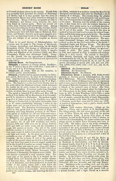
EDINCHIP HOUSE
and tumuli at many places in the county. Pictish forts
may probably have preceded the Castles of Edinburgh
and Roslin; and it is very possible that the caves at
Hawthornden House were either formed or enlarged by
the Picts also. Traces of Roman occupation are still to
be discerned ; and Roman coins, weapons, etc., have
been found in various parts. There are several old
castles, some forming most picturesque ruins. Among
the more interesting are those at Roslin, Catcune, Borth-
wick, Crichton, and Craigmillar. Extensive monastic
establishments have left their ruins at Holyrood, New-
battle, and Temple — the last, as its name suggests, hav-
ing been an important honse of the Knights Templars.
There are vestiges of an ancient hospital on Soutra
Hill.
There is no good history of Edinburghshire, but
reference may be made to The County of Edinburgh;
its Geology, Agriculture, and Meteorology, by Mr Ralph
Richardson (1878), The Geology of Edinburgh and its
Neighbourhood, by Sir Arch. Geikie (1879), J. Small's
Castles and Mansions of the Lothians (1883), and Miss
Warrender's Walks near Edinburgh (1890). Comp.
also Mr. Farrall ' On the Agriculture of Edinburgh-
shire, ' in Transactions of the Highland and Agricultural
Society (1877).
Edinchip House. See Balqtthidder.
Edingight, a mansion in Grange parish, Banffshire,
at the W skirt of Knock Hill (1409 feet), 7 miles NE of
Keith, and 4 N by E of Grange station.
Edinglassie, an estate, with an old mansion, in
Strathdon parish, Aberdeenshire.
Edington, a hamlet and an ancient fortalice in Chirn-
side parish, Berwickshire, 1\ miles E of Chirnside vil-
lage. Only the S side of the fortalice continues standing.
Edinkillie, a hamlet and a parish in the W of Elgin-
shire. The hamlet is on the small river Divie, close to
the point where the Highland railway, which intersects
the parish for 10 miles, crosses the stream on a lofty
seven-arched viaduct. It is about a mile from Duniphail
station, at which there is a post office under Forres.
The parish is bounded N by Dyke and Moy, NE by
Rafford, E by Dallas, SE by Knockando, S by Cromdale,
and W by Ardclach in Nairnshire. Its greatest length,
from N to S, from a point on the Findhorn near Mains
of Dalvey to Lochindorb, is 13£ miles; its breadth, from
E to W, varies considerably, attaining 7 miles at the
widest part; and its area is now 35,773 acres, of which
437| are water. The Boundary Commissioners in 1891
added to this parish (and to the county of Elgin) the
Glenerney and Lurg detached portions of the Nairn-
shire parish of Ardclach (of 750 and 2119 acres respec-
tively), which had been wholly and partly surrounded
by Edinkillie, and altogether encompassed by Elgin-
shire. The S and SE parts are mostly moorland and
hill pasture, the N and NW woodland and arable.
Between 3000 and 4000 acres are in tillage, between
4000 and 5000 are under wood, and the remainder is
rough hill pasture or heath. The soil of the arable
districts consists of a brown or black loam overlying
clay, sand, or gravel, and in some places the loam becomes
very light and sandy. In the upper part the moss lies
generally on clay or white sand. The surface is very
irregular. At the extreme N end of the parish the
height of the ground above sea-level is a little over 100
feet, and from that point it rises in rugged undulations
till in the S and E it reaches an average height of from
900 to 1000 feet, and rises in some places still higher,
the principal elevations bekig Romach Hill (1012 feet),
Hill of Tomechole (1129), Sliabh Bainneach (1453),
and Knock of Braemoray, the highest point (1493). The
last summit commands a very extensive view. The
upper part of the parish to the S is drained by the
streams Divie and Dorbock and the smaller streams
that flow into them. The Divie rises in Cromdale to
the S of Edinkillie, and flows northward to about the
middle of the parish, where, half a mile below the
church, it is joined by the Dokbock, which forms the
outlet for the waters of Lochindorb. From the point of
junction the united streams, still retaining the name of
528
EDNAM
the Divie, continue in a northern course for 2J miles by
Duniphail and Relugas, and enter the Findhorn a short
distance N of Relugas. The scenery along the greater
part of the courses of both streams is very picturesque.
The river Findhorn flows through the parish for 7 miles
of its course. Entering near the middle of the western
side, it first forms for a mile the western boundary of
Edinkillie, then passes across in a northerly direction,
and forms thereafter the eastern boundary for 3 miles at
the N end of the parish. The course of the river is
marked by fine rock and wood scenery, the vales of Logie,
Sluie, and St John being pai-ticularly pretty. The greater
portion of the district W of the Findhorn is covered
with part of the great forest of Darnaway. The man-
sions — Duniphail, Relugas, and Logie — are separately
noticed, as also are the chief antiquities of the parish —
Duniphail Castle and Relugas Doune. The principal
landowner is the Earl of Moray. The parish is in the
presbytery of Forres and synod of Moray; the minister',
income is £189. The parish church was erected
in 1741, and repaired in 1813; it contains 500 sittings.
There is a Free church. The schools of Duniphail,
• Half Davoch, Conicavel, and Logie, with respective
accommodation for 100, 50, 58, and' 116 children, have
an average attendance of about 50, 20, 50, and 60, and
grants amounting to nearly £50, £30, £50, and £60.
Pop. (1881) 1175, (1891) 1032.— Ord. Sur., shs. 84, 85,
1876-77.
Edinshall. See Cockbt/rnlaw.
Edleston. See Eddleston.
Edmonston Castle. See Biggar.
Edmonstone House, a mansion, with finely-wooded
grounds, in Newton parish, Edinburghshire, 3£ miles
SE of Edinburgh. The estate belonged, from 1248 and
earlier, to the family of Edmonstone, who are commonly
said to have come to Scotland in 1067 with St Margaret,
the queen of Malcolm Ceannmor, but who probably were
a branch of the powerful race of Seton. (See Dt/n-
treath. ) From them it passed, about the beginning of
the 17th century, to the Raits; and from them, by mar-
riage, in 1671, to John Wauchope (1633-1709), a cadet
of the Niddry "Wauchopes, who, in 1672, on becoming a
lord of session, assumed the title of Lord Edmonstone.
Its present holder is Sir John Douglas Don-Wauchope
of Newton, ninth Bart, since 1667 (b. 1859; sue. 1893).
A hamlet of Edmonstone, with a public school, stands
a little to the E.
Ednam (12th century EdnaJiam, 'village on the
Eden '), a village and a parish of N Roxburghshire.
The village stands, 190 feet above sea-level, on the left
bank of Eden Water, 2£ miles NNE of its station
and post-town, Kelso. A pretty little place, of hoar
antiquity, burned by the English in 1558, it retains, as
outhouse of a farmsteading, the former manse (and later
village school) in which James Thomson was born, 11
Sept. 1700. His father, nine or ten weeks afterwards,
was transferred to the ministry of Southdean ; but a
miniature of the poet, presented to the bygone Ednam
Club by the eleventh Earl of Buchan, is preserved in the
present manse; and in 1820 an obelisk, 52 feet high,
was erected to his memory on a rising-ground 1 mile to
the S of the village.
The parish is bounded N and NE by Eccles in
Berwickshire, SE by Sprouston, S and SW by Kelso, W
by Nenthorn in Berwickshire, and NW by Stichill.
Its utmost length, from E by N to W by S, is 3f miles;
its utmost breadth, from N to S, is 3J miles; and its
area is 3919f acres, of which 70J are water. The Tweed
sweeps 3 miles north-eastward along all the Sprouston
border; and Eden Water winds 4i miles eastward to it,
along the boundary with Nenthorn and through the
interior. In the furthest E the surface sinks along the
Tweed to 95 feet above sea-level, thence rising with
gentle undulation to 236 feet near Ferneyhill, 282 near
Cliftonhill, 278 near Kaimflat, and 265 near Harper-
town. Sandstone is the prevailing rock, and the soils
are of four kinds, in pretty equal proportions — loam,
incumbent on gravel; clay and light gravel, both on
a porous bottom ; and a light humus on a moorish
Set display mode to: Large image | Transcription
Images and transcriptions on this page, including medium image downloads, may be used under the Creative Commons Attribution 4.0 International Licence unless otherwise stated. ![]()
| Gazetteers of Scotland, 1803-1901 > Ordnance gazetteer of Scotland > (536) Page 528 |
|---|
| Permanent URL | https://digital.nls.uk/97399678 |
|---|

