Ordnance gazetteer of Scotland > Volume 6
(311) Page 489
Download files
Complete book:
Individual page:
Thumbnail gallery: Grid view | List view
WICK
the landward part (1881) 991 inhabited, 29 uninhabited,
and 1 being built.— Ord. Sur., shs. 116, 110, 1878-77.
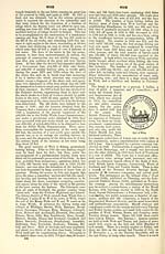
Wick, a royal burgh, seaport, seat of trade, and the
county town of Caithness, at the head of Wick Bay,
near the middle of the E coast of the parish just
described. It is the eastern terminus of the Sutherland
and Caithness section (1874) of the Highland railway, and
by rail is 161J miles NNE of Inverness. By roaditislSJ
miles S of Huna and John o' Groat's House, and 14| NNE
of Lybster. By sea it is about 50 miles S of Kirkwall,
and 110 MW of Aberdeen. The town may be said
to consist of three portions, Wick proper to the N of
Wick AYater, Louisburgh still farther N, and Pulteney-
town to the SE on the S side of Wick Water. The
burgh was formerly confined within narrow limits, but
in 18S3 the sheriff granted a petition praying for the
inclusion within the boundary of both Louisburgh and
the high ground on the opposite side of the river from
Wick about the railway station. In the time of the
Vikings, from whom it received its name, it seems to
have been a resort of some importance, and mention of
it occurs in the Sagas as early as 1140, when 'Earl
Rognvald went over to Caithness and was entertained
at Vik by a man named Harold ; ' but its modern
history may be said to date from 1589, when Wick
proper was constituted a royal burgh by charter of
James VI. So little idea, however, had the citizens as
to their rights and privileges thus obtained, that the
burgh practically remained under superiors — first the
Earls of Caithness and thereafter the families of Ulbster
and Sutherland — like a mere burgh of barony till the
Municipal Reform Act of 1833. There are no burgage
lands, and the Duke of Sutherland is still feudal
superior. Wick itself consists of a narrow crooked
street called High Street, running in a general line
N and S along the N bank of the river, and with
closes and lanes running off on both sides. It is
poorly edificed. Louisburgh, which dates from the
latter part of last century, lies to the N and NW.
Opening off High Street southward is the only well-
built street of the town, the short Bridge Street, which
crosses the river by a fine stone bridge of three arches
erected in 1874. This leads to Pulteneytown, which is
divided into Lower Pulteneytown, situated on low ground
adjoining the bank of the stream, and Upper Pulteney-
town, situated on the high ground overlooking the bay.
The greater portion of both lies along streets regularly
laid out at right angles, Upper Pulteneytown having in
addition a large but somewhat neglected central square.
This suburb, which is the seat of all the trade, and con-
tains more than half the whole population, was laid
out by the British Fisheries Society in 1808, shortly
before they commenced operations at the harbour, and
was designed to be a model fishing-town. Wick town-
hall, in Bridge Street, is a somewhat dingy building
with a sandstone front and a cupola-shaped belfry over
the doorway. The county buildings, erected in 1866
at a cost of £6000, are also in Bridge Street, and con-
tain a good court-room with retiring rooms and accom-
modation for the various county offices. The prison
behind the town-house has been disused since 1882.
The parish church, at the W end of the town, was erected
in 1S30 at a cost of £5000, and is a poor Gothic build-
ing with a spire. It contains 1900 sittings. The pre-
Keformation parish church, dedicated to St Fergus, is
supposed to have stood at Mount Halie, near the E end
of the town, but a more recent structure — the predecessor
of that removed to make way for the present building —
occupied a site close to the existing church. The only
traces of it now remaining are the structures called the
Sinclair Aisle and the Dunbar Tomb. At Pulteneytown
there is a quoad sacra church erected in 1842, and con-
taining 550 sittings. The Free church in Bridge Street
is a good building, erected in 1862. Of two Free
churches in Pulteneytown the one dates from the Dis-
ruption, and has a spire added in 1862. The other —
Reformed Presbyterian till 1S76 — was built in 1S39,
and contains 380 sittings. The United Presbyterian
church in Pulteneytown, built in 1878-79 at a cost of
WICK
£4000, and containing 700 sittings, replaced an older
church erected in 1815. The original Congregational
church in Wick, built in 1799, was replaced by the
present building on a different site in 1882. It contains
500 sittings. The Evangelical Union church, with 520
sittings, was erected in 1845. St John's Episcopal
church, in Pulteneytown, a building of 1870, Decorated
Gothic in style, has 150 sittings, and there are also a
small Baptist church (1809), with 150 sittings, and
St Joachim's Roman Catholic church in Pulteney-
town, erected in 1837, and containing 250 sittings.
The Temperance Hall, erected in 1842, has accommoda-
tion for about 1000 persons. Two of the bank offices
are very good buildings, and there is a fine hotel close
to the bridge erected at the time of the opening of the
railway. Besides the stone bridge at Bridge Street,
there is a wooden bridge farther down the river near
the harbour. The old burying ground was round the
church, but owing to its crowded condition, a new
cemetery was formed in 1872 to the S of Pulteneytown.
Under the burgh school board the Pulteneytown
Academy, North Wick and South Wick schools, with
accommodation for 519, 300, and 280 pupils respec-
tively, had, in 1884, attendances of 334, 234, and 259,
and grants of £323, 15s., £204, 15s., and £226, 8s. 6d.
The jurisdiction of the port of Wick extends from
Bonar-Bridge round all the E, N, and W coast as far as
Rhu Stoer on the W coast of Sutherland, and takes in
also the island of Stroma in the Pentland Firth. It
thus includes the harbours of Little Ferry, Helmsdale,
Lybster, Broadhaven, Scrabster, and Portskerry, besides
numerous creeks. Except as regards fishing-boats, the
shipping trade is mostly confined to Wick. In 1850 the
number of vessels belonging to the port was 54, with an
aggregate tonnage of 3445 ; in 1875 there were 65 sail-
ing vessels, with an aggregate tonnage of 6412, and 1
steam vessel, with a tonnage of 108 ; and in 1884 there
were 56 sailing vessels, with an aggregate tonnage of
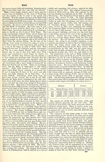
5085. The following table shows the tonnage of vessels
that entered from and to foreign and colonial ports and
coastwise with cargoes and ballast, in various years : —
Entered.
Cleared.
Year.
British.
Foreign.
Total.
British. 1 Foreign.
Total.
1S60
1S67
1874
18S3
103,706
79,358
92,840
103,714
4,770
5,271
5,310
13,651
108,476
84,629
98,150 ,
122,365
98,547 1 S.64S
75.S53 6,146
82,731 4,773
87,195 1 13,496
i
107,195
80,999
S7.509
100,560
The exports are chiefly fish, but grain, cattle, and
country produce generally are also sent away. The
imports are principally coal, wood, and goods suited for
a general country trade. There is regular steam com-
munication with Aberdeen and Granton twice a week
in summer and once in winter, and with Kirkwall and
Lerwick once a week.
The commerce of early times seems to have found
accommodation in the mouth of the river, and at small
jetties on the N side ; and no attempt to form a regular
harbour was made till 1810, when the first one was con-
structed, partly from Government funds, and partly
with money furnished by the British Fisheries Society,
originally founded in 17S6 for the purpose of developing
the fisheries round the British coasts. The works then
executed cost £14,000 ; but as they proved inadequate
for their purpose, improvements were carried out be-
tween 1825 and 1831 at a cost of £40,000, and the
works brought into the state in which they remained
down to 1882. From the increased size of vessels and
boats employed in connection with the fishing, this new
harbour was, within a few years, again found too small,
and in 1844 the Fisheries Society obtained an Act of
Parliament empowering them to enlarge it. Nothing
was, however, done, and in consequence of the insuffi-
cient nature of the accommodation, and the harbour's
being a tidal one, and having its mouth so placed to
shelter it from the sea that boats entering it had to
489
the landward part (1881) 991 inhabited, 29 uninhabited,
and 1 being built.— Ord. Sur., shs. 116, 110, 1878-77.
Wick, a royal burgh, seaport, seat of trade, and the
county town of Caithness, at the head of Wick Bay,
near the middle of the E coast of the parish just
described. It is the eastern terminus of the Sutherland
and Caithness section (1874) of the Highland railway, and
by rail is 161J miles NNE of Inverness. By roaditislSJ
miles S of Huna and John o' Groat's House, and 14| NNE
of Lybster. By sea it is about 50 miles S of Kirkwall,
and 110 MW of Aberdeen. The town may be said
to consist of three portions, Wick proper to the N of
Wick AYater, Louisburgh still farther N, and Pulteney-
town to the SE on the S side of Wick Water. The
burgh was formerly confined within narrow limits, but
in 18S3 the sheriff granted a petition praying for the
inclusion within the boundary of both Louisburgh and
the high ground on the opposite side of the river from
Wick about the railway station. In the time of the
Vikings, from whom it received its name, it seems to
have been a resort of some importance, and mention of
it occurs in the Sagas as early as 1140, when 'Earl
Rognvald went over to Caithness and was entertained
at Vik by a man named Harold ; ' but its modern
history may be said to date from 1589, when Wick
proper was constituted a royal burgh by charter of
James VI. So little idea, however, had the citizens as
to their rights and privileges thus obtained, that the
burgh practically remained under superiors — first the
Earls of Caithness and thereafter the families of Ulbster
and Sutherland — like a mere burgh of barony till the
Municipal Reform Act of 1833. There are no burgage
lands, and the Duke of Sutherland is still feudal
superior. Wick itself consists of a narrow crooked
street called High Street, running in a general line
N and S along the N bank of the river, and with
closes and lanes running off on both sides. It is
poorly edificed. Louisburgh, which dates from the
latter part of last century, lies to the N and NW.
Opening off High Street southward is the only well-
built street of the town, the short Bridge Street, which
crosses the river by a fine stone bridge of three arches
erected in 1874. This leads to Pulteneytown, which is
divided into Lower Pulteneytown, situated on low ground
adjoining the bank of the stream, and Upper Pulteney-
town, situated on the high ground overlooking the bay.
The greater portion of both lies along streets regularly
laid out at right angles, Upper Pulteneytown having in
addition a large but somewhat neglected central square.
This suburb, which is the seat of all the trade, and con-
tains more than half the whole population, was laid
out by the British Fisheries Society in 1808, shortly
before they commenced operations at the harbour, and
was designed to be a model fishing-town. Wick town-
hall, in Bridge Street, is a somewhat dingy building
with a sandstone front and a cupola-shaped belfry over
the doorway. The county buildings, erected in 1866
at a cost of £6000, are also in Bridge Street, and con-
tain a good court-room with retiring rooms and accom-
modation for the various county offices. The prison
behind the town-house has been disused since 1882.
The parish church, at the W end of the town, was erected
in 1S30 at a cost of £5000, and is a poor Gothic build-
ing with a spire. It contains 1900 sittings. The pre-
Keformation parish church, dedicated to St Fergus, is
supposed to have stood at Mount Halie, near the E end
of the town, but a more recent structure — the predecessor
of that removed to make way for the present building —
occupied a site close to the existing church. The only
traces of it now remaining are the structures called the
Sinclair Aisle and the Dunbar Tomb. At Pulteneytown
there is a quoad sacra church erected in 1842, and con-
taining 550 sittings. The Free church in Bridge Street
is a good building, erected in 1862. Of two Free
churches in Pulteneytown the one dates from the Dis-
ruption, and has a spire added in 1862. The other —
Reformed Presbyterian till 1S76 — was built in 1S39,
and contains 380 sittings. The United Presbyterian
church in Pulteneytown, built in 1878-79 at a cost of
WICK
£4000, and containing 700 sittings, replaced an older
church erected in 1815. The original Congregational
church in Wick, built in 1799, was replaced by the
present building on a different site in 1882. It contains
500 sittings. The Evangelical Union church, with 520
sittings, was erected in 1845. St John's Episcopal
church, in Pulteneytown, a building of 1870, Decorated
Gothic in style, has 150 sittings, and there are also a
small Baptist church (1809), with 150 sittings, and
St Joachim's Roman Catholic church in Pulteney-
town, erected in 1837, and containing 250 sittings.
The Temperance Hall, erected in 1842, has accommoda-
tion for about 1000 persons. Two of the bank offices
are very good buildings, and there is a fine hotel close
to the bridge erected at the time of the opening of the
railway. Besides the stone bridge at Bridge Street,
there is a wooden bridge farther down the river near
the harbour. The old burying ground was round the
church, but owing to its crowded condition, a new
cemetery was formed in 1872 to the S of Pulteneytown.
Under the burgh school board the Pulteneytown
Academy, North Wick and South Wick schools, with
accommodation for 519, 300, and 280 pupils respec-
tively, had, in 1884, attendances of 334, 234, and 259,
and grants of £323, 15s., £204, 15s., and £226, 8s. 6d.
The jurisdiction of the port of Wick extends from
Bonar-Bridge round all the E, N, and W coast as far as
Rhu Stoer on the W coast of Sutherland, and takes in
also the island of Stroma in the Pentland Firth. It
thus includes the harbours of Little Ferry, Helmsdale,
Lybster, Broadhaven, Scrabster, and Portskerry, besides
numerous creeks. Except as regards fishing-boats, the
shipping trade is mostly confined to Wick. In 1850 the
number of vessels belonging to the port was 54, with an
aggregate tonnage of 3445 ; in 1875 there were 65 sail-
ing vessels, with an aggregate tonnage of 6412, and 1
steam vessel, with a tonnage of 108 ; and in 1884 there
were 56 sailing vessels, with an aggregate tonnage of
5085. The following table shows the tonnage of vessels
that entered from and to foreign and colonial ports and
coastwise with cargoes and ballast, in various years : —
Entered.
Cleared.
Year.
British.
Foreign.
Total.
British. 1 Foreign.
Total.
1S60
1S67
1874
18S3
103,706
79,358
92,840
103,714
4,770
5,271
5,310
13,651
108,476
84,629
98,150 ,
122,365
98,547 1 S.64S
75.S53 6,146
82,731 4,773
87,195 1 13,496
i
107,195
80,999
S7.509
100,560
The exports are chiefly fish, but grain, cattle, and
country produce generally are also sent away. The
imports are principally coal, wood, and goods suited for
a general country trade. There is regular steam com-
munication with Aberdeen and Granton twice a week
in summer and once in winter, and with Kirkwall and
Lerwick once a week.
The commerce of early times seems to have found
accommodation in the mouth of the river, and at small
jetties on the N side ; and no attempt to form a regular
harbour was made till 1810, when the first one was con-
structed, partly from Government funds, and partly
with money furnished by the British Fisheries Society,
originally founded in 17S6 for the purpose of developing
the fisheries round the British coasts. The works then
executed cost £14,000 ; but as they proved inadequate
for their purpose, improvements were carried out be-
tween 1825 and 1831 at a cost of £40,000, and the
works brought into the state in which they remained
down to 1882. From the increased size of vessels and
boats employed in connection with the fishing, this new
harbour was, within a few years, again found too small,
and in 1844 the Fisheries Society obtained an Act of
Parliament empowering them to enlarge it. Nothing
was, however, done, and in consequence of the insuffi-
cient nature of the accommodation, and the harbour's
being a tidal one, and having its mouth so placed to
shelter it from the sea that boats entering it had to
489
Set display mode to: Large image | Transcription
Images and transcriptions on this page, including medium image downloads, may be used under the Creative Commons Attribution 4.0 International Licence unless otherwise stated. ![]()
| Gazetteers of Scotland, 1803-1901 > Ordnance gazetteer of Scotland > Volume 6 > (311) Page 489 |
|---|
| Permanent URL | https://digital.nls.uk/97391334 |
|---|
| Attribution and copyright: |
|
|---|---|
| Description | A survey of Scottish topography, statistical, biographical, and historical. Edited by Francis H. Groome. Edinburgh: Thomas C. Jack, 1884-85. "General survey": v.6, 134 p. at end. |
|---|---|
| Shelfmark | Map.Ref.C18 |
| Additional NLS resources: | |
| Description | 20 volumes of the most popular descriptive gazetteers of Scotland, providing a comprehensive geographical encyclopaedia of Scotland in the 19th century. Principal places in Scotland, including towns, counties, castles, glens, antiquities and parishes, are listed alphabetically. Each entry includes detailed historical and geographical information about each place. |
|---|---|