Ordnance gazetteer of Scotland > Volume 5
(184) Page 96
Download files
Complete book:
Individual page:
Thumbnail gallery: Grid view | List view
NAIRNSHIRE
direction, and was gradually deflected towards the E
and ESE on approaching the plains of Nairn and Moray.
In certain parts of the county there are two distinct
boulder clays, which are separated by an important
series of inter-glacial sands, gravels, and finely lami-
nated clays. The older of the two boulder clays is
usually more tenacious than that which overlies the
inter-glacial beds, and the stones are generally more
distinctly grooved. Admirable sections showing the
order of succession of this glacial series are exposed in
the streams draining the Cawdor moors. An examina-
tion of the stones embedded in the boulder clays shows
that even in the areas occupied by the gneiss striated
blocks of red sandstone occur in considerable abundance,
thus indicating that the ice was compelled to move E
along the slopes of the hills, bearing along with it the
detritus from the Old Red Sandstone tracts to the areas
occupied by the metamorphic series. In the valley of
the Nairn, at Clava, Mr Eraser, O.E., Inverness, has
obtained marine shells from fine blue clay belonging to
this inter-glacial series. The upper part of the section
is composed of yellowish boulder clay, consisting of
gravel, sand, and stones, with a mixture of clay, which
reaches a depth of 45 feet. About 20 feet of sand
underlies the boulder clay, and below the fine sand the
shelly clay is met with, the bottom of which has not
been pierced. A few smooth stones occur in the shelly
clay, but they are not so numerous as in ordinary
boulder clay. Indeed, from the nature of the deposit, as
well as from the state of preservation of the shells, it is
evident that these stratified sands and clays indicate a
depression of the land in inter-glacial times. The
height of the shelly clay is about 500 feet above the
present sea-level, so that the submergence must have
■equalled, if it did not exceed, this amount. The
following shells were noted from this section : Littorina
litorea, Lcda 'pernula, Natim Groenlandica, PUurotoma
turriada, Nuciila tenuis, Tellina Balthica, Cardium
edule, Astartc com^nessa, Bucciniim imdatum, etc. The
clays also yielded a considerable number of species of
Foraminifera,
Resting on the upper boulder clay there is a great
development of moraiuic gravels on the moory ground
between the basins of the Nairn and Findhorn ; some-
times forming long sinuous ridges upwards of J
mile in length, which enclose shallow lochans or
patches of peat. By far the most interesting develop-
ment of the kamiform series occurs on the low ground
between Nairn and the W boundary of the county.
Beginning at Meikle Kildrummie this prominent ridge
of sand and shingle is traceable W to Loch Flemington,
a distance of 3 miles. At the former locality the
height of the kames is about 100 feet above the sea-level,
and towards the W limit they rise to the level of 140
feet. This long kame forms a prominent feature on the
broad platform of sand and gravel to the S of the rail-
way between Nairn and Fort George. It stands indeed
at the edge of the belt of fertile ground formed by
the 100-feet ten'ace. In addition to this ancient terrace
there are remains of the 50-feet beach to the E of the
town of Nairn, though of limited extent. But along the
shores of the firth between Fort George and the mouth
of the Findhorn the 25-feet terrace is well developed,
though covered to a considerable extent by vast accumu-
lations of blown sand. The inland cliff, consisting of
stratified sands, gravel, and clay, resting on boulder
clay, which marks the border of this ancient beach, is
easily followed from Fort George to Loch Loy. The
terrace is of variable breadth, sometimes measuring only
200 yards from the present coast-line, sometimes 2J
miles across. One of the most interesting features con-
nected with this sea beach is the great development of
sand drift on its surface, particularly in the neighbour-
hood of Culbin. Formerly one of the most fertile tracts
in the province of Moray, where stood the mansion-
house of Culbin among richly cultivated fields and
homesteads, the area occupied by the Culbin sandhills
is now but a desert waste, whose contour is changed by
■«very wind that blows. The invasion of the sand-drift
96
NAIRNSHIRE
took place in 1694, and so effectual was the inroad that
only a small portion of the estate escaped, which was
buried by succeeding storms. Various interesting reHcs
are now and again picked up where the drifting of the
sand has laid bare part of the old cultivated laud.
These consist of coins and farm implements, but
numerous flint arrow heads belonging to neolithic
times are also met with in isolated heaps. A consider-
able development of sand dunes rests on the 25-feet
beach near Fort George, but to the E of the town of
Nairn, between Loch Loy and the mouth of the Find-
horn, the features which they present are worthy of
special note. The Maviston Sandhills, which lie about
4 miles to the E of Nairn, consist of two prominent
dome-shaped masses of sand — the one lying to the E of
the other — which are partly surrounded by small conical
heaps of sand. Each of these sand domes slopes gently
to the W at an angle of 5°, while at the E limit the
angle of inclination is between 30° and 40°. Beyond
the county boundary the extensive forest named the
Low Wood covers the plain of the 25-feet beach, which is
dotted at intervals with minor accumulations of blown
sand. To the E of this plantation lies the tract of the
Culbin Sands, measuring about 3 miles in length and
about 2 miles in breadth. The centre of the area is
occupied by a succession of great ridges of sand upwards
of 100 feet high, sloping towards the W at a gentle
angle of a few degrees and with a much higher inclina-
tion towards the E. These dome-shaped accumulations
are surrounded by conical heaps and ridges trending
from WSW to ENE, and var3'ing in height from 10 to
30 feet. The surface of the great domes as well as the
minor heaps are beautifully ripple-marked by the wind,
and sections of the mounds display excellent examples
of false bedding. With reference to the question of their
origin the following explanation has recently been
given : ' There is a combination of circumstances in
that district favourable to their- formation. The Find-
horn carries an enormous quantity of sand at present to
the sea every year, and this denudation must have jjro-
eeeded steadily since glacial times. When this sediment
is discharged into the sea, it is borne W and SW by the
currents along the shore, and is eventually deposited
on the shelving beach by tidal action. It is then
caught up by the winds and borne inland in an E
direction. But in addition to this it is highly probable
that the prevalent W winds caught up the deposits of
sand belonging to the 100-feet beach and swept them
onwards in the direction of the Culbin area. Viewed
in this light these sandhills give us some idea of the
enormous denudation which is constantly going on over
the surface of the land. ' The course of the Findhorn at
its mouth was changed after the advance of the Culbin
Sands. Formerly it flowed W from Binsness for a
distance of 3 miles and joined the sea at the old bar, but
owing probably to the sand drift it was compelled to
flow N into the sea.
Soils and Agriculture. — The soU in the eastern part
of the ' laich ' is a rich free loam, overlying sand or
gravel, and in the western part is in some places a stiff
strong clay, in others a sharp mould inclining to
gravel. In the uplands the arable lands are haughs
along the valleys of the streams, or light stony, or sandy,
soU on the slopes and braes. The arable land is mostly
in the coast and centre district, and the proportion fit
for cultivation found among the uplands and mountains
is less than in most other counties. Great improvement
has taken place during the present century. The acreages
under the various crops at different dates are given in
the following tables : —
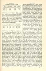
Graik Crops. — Acres.
Year. | Wheat.
Barley or Bere.
Oats. Total.
1854, . .
1870, . .
1877, . .
1883, . .
1714J
266
91
35
3130i
2237'
2701
3099
77521
6089
6045
B897
12,597i
8,692
8,837
9,031
direction, and was gradually deflected towards the E
and ESE on approaching the plains of Nairn and Moray.
In certain parts of the county there are two distinct
boulder clays, which are separated by an important
series of inter-glacial sands, gravels, and finely lami-
nated clays. The older of the two boulder clays is
usually more tenacious than that which overlies the
inter-glacial beds, and the stones are generally more
distinctly grooved. Admirable sections showing the
order of succession of this glacial series are exposed in
the streams draining the Cawdor moors. An examina-
tion of the stones embedded in the boulder clays shows
that even in the areas occupied by the gneiss striated
blocks of red sandstone occur in considerable abundance,
thus indicating that the ice was compelled to move E
along the slopes of the hills, bearing along with it the
detritus from the Old Red Sandstone tracts to the areas
occupied by the metamorphic series. In the valley of
the Nairn, at Clava, Mr Eraser, O.E., Inverness, has
obtained marine shells from fine blue clay belonging to
this inter-glacial series. The upper part of the section
is composed of yellowish boulder clay, consisting of
gravel, sand, and stones, with a mixture of clay, which
reaches a depth of 45 feet. About 20 feet of sand
underlies the boulder clay, and below the fine sand the
shelly clay is met with, the bottom of which has not
been pierced. A few smooth stones occur in the shelly
clay, but they are not so numerous as in ordinary
boulder clay. Indeed, from the nature of the deposit, as
well as from the state of preservation of the shells, it is
evident that these stratified sands and clays indicate a
depression of the land in inter-glacial times. The
height of the shelly clay is about 500 feet above the
present sea-level, so that the submergence must have
■equalled, if it did not exceed, this amount. The
following shells were noted from this section : Littorina
litorea, Lcda 'pernula, Natim Groenlandica, PUurotoma
turriada, Nuciila tenuis, Tellina Balthica, Cardium
edule, Astartc com^nessa, Bucciniim imdatum, etc. The
clays also yielded a considerable number of species of
Foraminifera,
Resting on the upper boulder clay there is a great
development of moraiuic gravels on the moory ground
between the basins of the Nairn and Findhorn ; some-
times forming long sinuous ridges upwards of J
mile in length, which enclose shallow lochans or
patches of peat. By far the most interesting develop-
ment of the kamiform series occurs on the low ground
between Nairn and the W boundary of the county.
Beginning at Meikle Kildrummie this prominent ridge
of sand and shingle is traceable W to Loch Flemington,
a distance of 3 miles. At the former locality the
height of the kames is about 100 feet above the sea-level,
and towards the W limit they rise to the level of 140
feet. This long kame forms a prominent feature on the
broad platform of sand and gravel to the S of the rail-
way between Nairn and Fort George. It stands indeed
at the edge of the belt of fertile ground formed by
the 100-feet ten'ace. In addition to this ancient terrace
there are remains of the 50-feet beach to the E of the
town of Nairn, though of limited extent. But along the
shores of the firth between Fort George and the mouth
of the Findhorn the 25-feet terrace is well developed,
though covered to a considerable extent by vast accumu-
lations of blown sand. The inland cliff, consisting of
stratified sands, gravel, and clay, resting on boulder
clay, which marks the border of this ancient beach, is
easily followed from Fort George to Loch Loy. The
terrace is of variable breadth, sometimes measuring only
200 yards from the present coast-line, sometimes 2J
miles across. One of the most interesting features con-
nected with this sea beach is the great development of
sand drift on its surface, particularly in the neighbour-
hood of Culbin. Formerly one of the most fertile tracts
in the province of Moray, where stood the mansion-
house of Culbin among richly cultivated fields and
homesteads, the area occupied by the Culbin sandhills
is now but a desert waste, whose contour is changed by
■«very wind that blows. The invasion of the sand-drift
96
NAIRNSHIRE
took place in 1694, and so effectual was the inroad that
only a small portion of the estate escaped, which was
buried by succeeding storms. Various interesting reHcs
are now and again picked up where the drifting of the
sand has laid bare part of the old cultivated laud.
These consist of coins and farm implements, but
numerous flint arrow heads belonging to neolithic
times are also met with in isolated heaps. A consider-
able development of sand dunes rests on the 25-feet
beach near Fort George, but to the E of the town of
Nairn, between Loch Loy and the mouth of the Find-
horn, the features which they present are worthy of
special note. The Maviston Sandhills, which lie about
4 miles to the E of Nairn, consist of two prominent
dome-shaped masses of sand — the one lying to the E of
the other — which are partly surrounded by small conical
heaps of sand. Each of these sand domes slopes gently
to the W at an angle of 5°, while at the E limit the
angle of inclination is between 30° and 40°. Beyond
the county boundary the extensive forest named the
Low Wood covers the plain of the 25-feet beach, which is
dotted at intervals with minor accumulations of blown
sand. To the E of this plantation lies the tract of the
Culbin Sands, measuring about 3 miles in length and
about 2 miles in breadth. The centre of the area is
occupied by a succession of great ridges of sand upwards
of 100 feet high, sloping towards the W at a gentle
angle of a few degrees and with a much higher inclina-
tion towards the E. These dome-shaped accumulations
are surrounded by conical heaps and ridges trending
from WSW to ENE, and var3'ing in height from 10 to
30 feet. The surface of the great domes as well as the
minor heaps are beautifully ripple-marked by the wind,
and sections of the mounds display excellent examples
of false bedding. With reference to the question of their
origin the following explanation has recently been
given : ' There is a combination of circumstances in
that district favourable to their- formation. The Find-
horn carries an enormous quantity of sand at present to
the sea every year, and this denudation must have jjro-
eeeded steadily since glacial times. When this sediment
is discharged into the sea, it is borne W and SW by the
currents along the shore, and is eventually deposited
on the shelving beach by tidal action. It is then
caught up by the winds and borne inland in an E
direction. But in addition to this it is highly probable
that the prevalent W winds caught up the deposits of
sand belonging to the 100-feet beach and swept them
onwards in the direction of the Culbin area. Viewed
in this light these sandhills give us some idea of the
enormous denudation which is constantly going on over
the surface of the land. ' The course of the Findhorn at
its mouth was changed after the advance of the Culbin
Sands. Formerly it flowed W from Binsness for a
distance of 3 miles and joined the sea at the old bar, but
owing probably to the sand drift it was compelled to
flow N into the sea.
Soils and Agriculture. — The soU in the eastern part
of the ' laich ' is a rich free loam, overlying sand or
gravel, and in the western part is in some places a stiff
strong clay, in others a sharp mould inclining to
gravel. In the uplands the arable lands are haughs
along the valleys of the streams, or light stony, or sandy,
soU on the slopes and braes. The arable land is mostly
in the coast and centre district, and the proportion fit
for cultivation found among the uplands and mountains
is less than in most other counties. Great improvement
has taken place during the present century. The acreages
under the various crops at different dates are given in
the following tables : —
Graik Crops. — Acres.
Year. | Wheat.
Barley or Bere.
Oats. Total.
1854, . .
1870, . .
1877, . .
1883, . .
1714J
266
91
35
3130i
2237'
2701
3099
77521
6089
6045
B897
12,597i
8,692
8,837
9,031
Set display mode to: Large image | Transcription
Images and transcriptions on this page, including medium image downloads, may be used under the Creative Commons Attribution 4.0 International Licence unless otherwise stated. ![]()
| Gazetteers of Scotland, 1803-1901 > Ordnance gazetteer of Scotland > Volume 5 > (184) Page 96 |
|---|
| Permanent URL | https://digital.nls.uk/97386158 |
|---|
| Attribution and copyright: |
|
|---|---|
| Description | A survey of Scottish topography, statistical, biographical, and historical. Edited by Francis H. Groome. Edinburgh: Thomas C. Jack, 1884-85. "General survey": v.6, 134 p. at end. |
|---|---|
| Shelfmark | Map.Ref.C18 |
| Additional NLS resources: | |
| Description | 20 volumes of the most popular descriptive gazetteers of Scotland, providing a comprehensive geographical encyclopaedia of Scotland in the 19th century. Principal places in Scotland, including towns, counties, castles, glens, antiquities and parishes, are listed alphabetically. Each entry includes detailed historical and geographical information about each place. |
|---|---|