Ordnance gazetteer of Scotland > Volume 5
(42) Page 524 - LIN
Download files
Complete book:
Individual page:
Thumbnail gallery: Grid view | List view
LINLITHGOWSHIRE
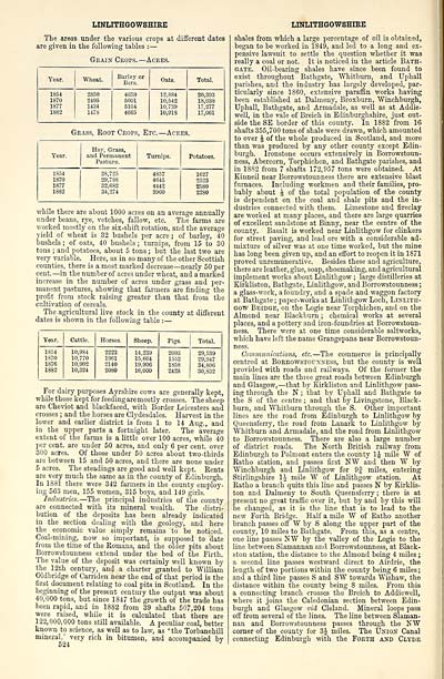
The areas under tlie various crops at different dates
are given in the following tables : —
Grain Crops. — Acees.
Tear.
Wheat.
Barley or
Bere.
Oats.
Total.
1854
1870
1877
1882
2850
2495
1434
1478
4659
6001
6104
4665
12,884
10,542
10,739
10,913
20,393
18,038
17,277
17,061
Grass, Root Crops, Etc. — Acres.
Year.
Hay. Grass,
and Permanent
Pasture.
Turnips.
Potatoes.
1834
1870
1877
1882
28,725
29,788
82,682
34,274
4857
4645
4442
3900
1627
2523
2580
2280
while there are about 1000 acres on an average annually
under beans, rye, vetches, fallow, etc. The farms are
worked mostly on the six-shift rotation, and the average
yield of wheat is 32 bushels per acre ; of barley, 40
bushels ; of oats, 40 bushels ; turnips, from 15 to 30
tons ; and potatoes, about 5 tons ; but the last two are
very variable. Here, as in so many of the other Scottish
counties, there is a most marked decrease — nearly 50 per
cent. — in thenumberof acres under wheat, and a marked
increase in the number of acres under grass and per-
manent pastures, showing that farmers are finding the
profit from stock raising greater than that from the
cultivation of cereals.
The agricultural live stock in the county at different
dates is shown in the following table : —
Tear.
Cattle.
Horses.
Sheep.
Pigs.
Total.
1854
1S70
1876
1882
10,984
10,770
10,902
10,324
2223
1961
2140
2080
14,239
15,664
19,906
16,000
2093
1552
1858
2428
29,539
29,947
34,806
30,832
For dairy purposes Ayrshire cows are generally kept,
whilethosekeptforfeedingaremostly crosses. Thesheep
are Cheviot and blackfaced, with Border Leicesters and
crosses ; and the horses are Clydesdales. Harvest in the
lower and earlier district is from 1 to 14 Aug., and
in the upper parts a fortnight later. The average
extent of the farms is a little over 100 acres, while 40
per cent, are under 50 acres, and only 6 per cent, over
300 acres. Of those under 50 acres about two-thirds
are between 15 and 50 acres, and there are none under
5 acres. The steadings are good and well kept. Rents
are very much the same as in the county of Edinburgh.
In 1881 there were 342 farmers in the county employ-
ing 563 men, 155 women, 315 boys, and 149 girls.
Industries. — The principal industries of the county
are connected with its mineral wealth. The distri-
bution of the deposits has been already indicated
in the section dealing with the geology, and here
the economic value simply remains to be noticed.
Coal-mining, now so important, is supposed to date
from the time of the Romans, and the older pits about
Borrowstounness extend under the bed of the Firth.
The value of the deposit was certainly well known by
the 12th century, and a charter granted to William
Oldbridge of Carriden near the end of that period is the
first document relating to coal pits in Scotland. In the
beginning of the present century the output was about
40,000 tons, but since 1847 the growth of the trade has
been rapid, and in 1882 from 39 shafts 507,204 tons
were raised, while it is calculated that there are
122,000,000 tons still available. A peculiar coal, better
known to science, as well as to law, as ' the Torbanehill
mineral,' very rich in bitumen, and accompanied by
LINLITHGOWSHIRE
shales from which a large percentage of oil is obtained,
began to be worked in 1849, and led to a long and ex-
pensive lawsuit to settle the question whether it was
really a coal or not. It is noticed in the article Bath-
gate. Oil-bearing shales have since been found to
exist throughout Bathgate, Whitburn, and Uphall
parishes, anil the industry has largely developed, par-
ticularly since 1860, extensive paraffin works having
been established at Dalmeuy, Broxburn, Winchburgh,
Uphall, Bathgate, and Armadale, as well as at Addie-
well, in the vale of Breich in Edinburgh.shire, just out-
side the SE border of this county. In 1882 from 16
shafts 355,700 tons of shale were drawn, which amounted
to over J of the whole produced in Scotland, and more
than was produced by any other county except Edin-
burgh. Ironstone occurs extensively in Borrowstoun-
ness, Abercorn, Torphichen, and Bathgate parishes, and
in 18S2 from 7 shafts 172,957 tons were obtained. At
Kinneil near Borrowstounness there are extensive blast
furnaces. Including workmen and their families, pro-
bably about J of the total population of the county
is dependent on the coal and shale pits and the in-
dustries connected with them. Limestone and fireclay
are worked at many places, and there are large quarries
of excellent sandstone at Binny, near the centre of the
county. Basalt is worked near Linlithgow for clinkers
for street paving, and lead ore with a considerable ad-
mixture of silver was at one time worked, but the mine
has long been given up, and an effort to reopen it in 1871
proved unremunerative. Besides these and agriculture,
there are leather, glue, soap, shoemaking, and agricultural
implement works about Linlithgow ; large distilleries at
Kirkliston, Bathgate, Linlithgow, and Borrowstounness;
a glass-work, a foundry, and a spade and waggon factory
at Bathgate ; paper- works at Linlithgow Loch, Linlith-
gow Bridge, on the Logic near Torphichen, and on the
Almond near Blackburn ; chemical works at several
places, and a pottery and iron-foundries at Borrowstoun-
ness. There were at one time considerable saltworks,
which have left the name Grangepans near Borrowstoun-
ness.
Communications, etc. — The commerce is principally
centred at BoEROWSTorxxESS, but the county is well
provided with roads and railways. Of the former the
main lines are the three great roads between Edinburgh
and Glasgow, — that by Kirkliston and Linlithgow pass-
ing through the N ; that by Uphall and Bathgate to
the S of the centre ; and that by Livingstone, Black-
burn, and Whitburn through the S. Other important
lines are the road from Edinburgh to Linlithgow by
Queensferry, the road from Lanark to Linlithgow by
Whitburn and Armadale, and the road from Linlithgow
to Borrowstounness. There are also a large number
of district roads. The North British railway from
Edinburgh to Polmont enters the county IJ mile W of
Ratho station, and passes first NW and then W by
Winchburgh aud Linlithgow for 9f miles, entering
Stirlingshire IJ mile W of Linlithgow station. At
Ratho a branch quits this line and passes N by Kirklis-
ton and Dalmeny to South Queensferry ; there is at
present no great traffic over it, but by and by this will
be changed, as it is the line that is to lead to the
new Forth Bridge. Half a mile W of Ratho another
branch passes ofi' W by S along the upper part of the
county, 10 miles to Bathgate. From this, as a centre,
one line passes NW by the valley of the Logie to the
line between Slamannan and Borrowstounness, at Black-
ston station, the distance to the Almond being 4 miles ;
a second line passes westward direct to Airdrie, the
length of two portions within the county being 6 miles;
and a third line passes S and SW towards Wishaw, the
distance within the county being 8 miles. From this
a connecting branch crosses the Breich to Addiewell,
where it joins the Caledonian section between Edin-
burgh and Glasgow vid Cleland. Mineral loops pass
off from several of the lines. The line between Slaman-
nau and Borrowstounness passes through the NW
comer of the county for 3J miles. The Union Canal
connecting Edinburgh with the Forth and Clyde
Set display mode to: Large image | Transcription
Images and transcriptions on this page, including medium image downloads, may be used under the Creative Commons Attribution 4.0 International Licence unless otherwise stated. ![]()
| Gazetteers of Scotland, 1803-1901 > Ordnance gazetteer of Scotland > Volume 5 > (42) Page 524 - LIN |
|---|
| Permanent URL | https://digital.nls.uk/97384454 |
|---|
| Attribution and copyright: |
|
|---|---|
| Description | A survey of Scottish topography, statistical, biographical, and historical. Edited by Francis H. Groome. Edinburgh: Thomas C. Jack, 1884-85. "General survey": v.6, 134 p. at end. |
|---|---|
| Shelfmark | Map.Ref.C18 |
| Additional NLS resources: | |
| Description | 20 volumes of the most popular descriptive gazetteers of Scotland, providing a comprehensive geographical encyclopaedia of Scotland in the 19th century. Principal places in Scotland, including towns, counties, castles, glens, antiquities and parishes, are listed alphabetically. Each entry includes detailed historical and geographical information about each place. |
|---|---|