Ordnance gazetteer of Scotland > Volume 4
(264) Page 478 - LAW
Download files
Complete book:
Individual page:
Thumbnail gallery: Grid view | List view

LAW CASTLE
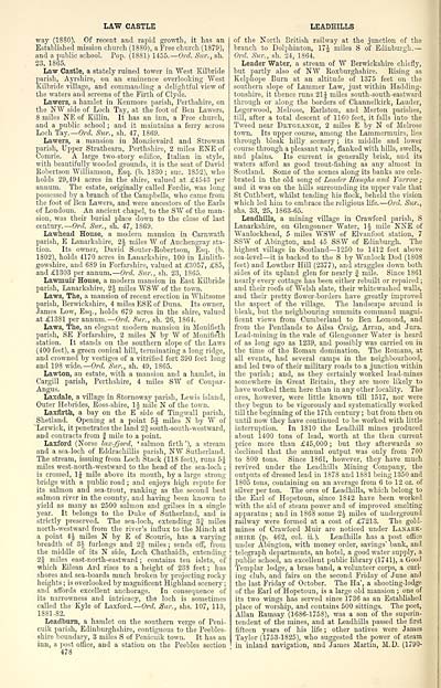
way (1880). Of recent and rapid growth, it has an
Established mission church (1880), a Free church (1879),
and a public school. Pop. (1881) 1455. — Orel. Sur., sh.
23, 1865.
Law Castle, a stately ruined tower in "West Kilbride
parish, Ayrshire, on an eminence overlooking "West
Kilbride village, and commanding a delightful view of
the waters and screens of the Firth of Clyde.
Lawers, a hamlet in Kenmore parish, Perthshire, on
the NW side of Loch Tay, at the foot of Ben Lawers,
8 miles NE of Killin. It has an inn, a Free church,
and a public school ; and it maintains a ferry across
Loch Tay.— Ord. Sur., sh. 47, 1869.
Lawers, a mansion in Monzievaird and Strowan
parish, Upper Strathearn, Perthshire, 2 miles ENE of
Connie. A large two-story edifice, Italian in style,
with beautifully wooded grounds, it is the seat of David
Robertson Williamson, Esq. (b. 1830 ; sue. 1852), who
holds 29,494 acres in the shire, valued at £4543 per
annum. The estate, originally called Fordie, was long
possessed by a branch of the Campbells, who came from
the foot of Ben Lawers, and were ancestors of the Earls
of Loudoun. An ancient chapel, to the SW of the man-
sion, was their burial place down to the close of last
century.— Ord. Sur., sh. 47, 1S69.
Lawhead House, a modern mansion in Carnwath
parish, E Lanarkshire, 1\ miles W of Auchengray sta-
tion. Its owner, David Souter-Robertson, Esq. (b.
1802), holds 4170 acres in Lanarkshire, 100 in Linlith-
gowshire, and 689 in Forfarshire, valued at £3057, £85,
and £1303 per annum. — Ord. Sur., sh. 23, 1865.
Lawmuir House, a modern mansion in East Kilbride
parish, Lanarkshire, 2J miles WSW of the town.
Laws, The, a mansion of recent erection in Whitsome
parish, Berwickshire, 4 miles ESE of Duns. Its owner,
James Low, Esq., holds 679 acres in the shire, valued
at £13S1 per annum. —Ord. Sur., sh. 26, 1864.
Laws, The, an elegant modern mansion in Monifieth
parish, SE Forfarshire, 2 miles N by W of Monifieth
station. It stands on the southern slope of the Laws
(400 feet), a green conical hill, terminating a long ridge,
and crowned by vestiges of a vitrified fort 390 feet long
and 198 wide.— Ord. Sur., sh. 49, 1865.
Lawton, an estate, with a mansion and a hamlet, in
Cargill parish, Perthshire, 4 miles SW of Coupar-
Angus.
Laxdale, a village in Stornoway parish, Lewis island,
Outer Hebrides, Ross-shire, 1 J mile N of the town.
Laxfirth, a bay on the E side of Tingwall parish,
Shetland. Opening at a point 5J miles N by AV of
Lerwick, it penetrates the land 2§ south-south-westward,
and contracts from J mile to a point.
Laxford (Norse lax-fjord, ' salmon firth '), a stream
and a sea-loch of Eddrachillis parish, NW Sutherland.
The stream, issuing from Loch Stack (118 feet), runs 5J
miles west-north-westward to the head of the sea-loch ;
is crossed, 1J mile above its mouth, by a large strong
bridge with a public road ; and enjoys high repute for
its salmon and sea-trout, ranking as the second best
salmon river in the county, and having been known to
yield as many as 2500 salmon and grilses in a single
year. It belongs to the Duke of Sutherland, and is
strictly preserved. The sea-loch, extending 3jf miles
north-westward from the river's influx to the Minch at
a point 4J miles N by E of Scourie, has a varying
breadth of 3-| furlongs and 2| miles ; sends off, from
the middle of its N side, Loch Chathaidh, extending
2| miles east-north-eastward ; contains ten islets, of
which Eilean Ard rises to a height of 238 feet ; has
shores and sea-boards much broken by projecting rocky
heights ; is overlooked by magnificent Highland scenery ;
and affords excellent anchorage. In consequence of
its narrowness and intricacy, the loch is sometimes
called the Kyle of Laxford.— Ord. Sur., shs. 107, 113,
1881-82.
Leadburn, a hamlet on the southern verge of Peni-
cuik parish, Edinburghshire, contiguous to the Peebles-
shire boundary, 3 miles S of Penicuik town. It has an
inn, a post office, and a station on the Peebles section
478
LEADHILLS
of the North British railway at the junction of the
branch to Dolphinton, 174 miles S of Edinburgh. —
Ord. Sur., sh. 24, 1864.
Leader Water, a stream of W Berwickshire chiefly,
but partly also of NW Roxburghshire. Rising as
Kelphope Burn at an altitude of 1375 feet on the
southern slope of Lammer Law, just within Hadding-
tonshire, it thence runs 21| miles south-south-eastward
through or along the borders of Channelkirk, Lauder,
Legerwood, Melrose, Earlston, and Merton parishes,
till, after a total descent of 1160 feet, it falls into the
Tweed near Dkygeange, 2 miles E by N of Melrose
town. Its upper course, among the Lammermuirs, lies
through bleak hilly scenery ; its middle and lower
course through a pleasant vale, flanked with hills, swells,
and plains. Its current is generally brisk, and its
waters afford as good trout-fishing as any almost in
Scotland. Some of the scenes along its banks are cele-
brated in the old song of Leader Haughs and Yarrow ;
and it was on the hills surrounding its upper vale that
St Cuthbert, whilst tending his flock, beheld the vision
which led him to embrace the religious life. — Ord. Sur.,
shs. 33, 25, 1863-65.
Leadhills, a mining village in Crawford parish, S
Lanarkshire, on Glengonner Water, \\ mile NNE of
Wanlockhead, 5 miles WSW of Elvanfoot station, 7
SSW of Abington, and 45 SSW of Edinburgh. The
highest village in Scotland — 1250 to 1412 feet above
sea-level — it is backed to the S by Wanlock Dod (180S
feet) and Lowther Hill (2377), and straggles down both
sides of its upland glen for nearly f mile. Since 1S61
nearly every cottage has been either rebuilt or repaired ;
and their roofs of Welsh slate, their whitewashed walls,
and their pretty flower-borders have greatly improved
the aspect of the village. The landscape around is
bleak, but the neighbouring summits command magni-
ficent views from Cumberland to Ben Lomond, and
from the Pentlands to Ailsa Craig, Arran, and Jura.
Lead-mining in the vale of Glengonner Water is heard
of as long ago as 1239, and possibly was carried on in
the time of the Roman domination. The Romans, at
all events, had several camps in the neighbourhood,
and led two of their military roads to a junction within
the parish ; and, as they certainly worked lead-mines
somewhere in Great Britain, they are more likely to
have worked them here than in any other locality. The
ores, however, were little known till 1517, nor were
they begun to be vigorously and systematically worked
till the beginning of the 17th century ; but from then on
until now they have continued to be worked with little
interruption. In 1810 the Leadhill mines produced
about 1400 tons of lead, worth at the then current
price more than £45,000 ; but they afterwards so
declined that the annual output was only from 700
to 800 tons. Since 1861, however, they have much
revived under the Leadhills Mining Company, the
outputs of dressed lead in 1878 and 1881 being 1350 and
1S05 tons, containing on an average from 6 to 12 oz. of
silver per ton. The ores of Leadhills, which belong to
the Earl of Hopetoun, since 1842 have been worked
with the aid of steam power and of improved smelting
apparatus ; and in 1868 some 2J miles of underground
railway were formed at a cost of £7213. The gold-
mines of Crawford Muir are noticed under Lanark-
shire (p. 462, col. ii. ). Leadhills has a post office
under Abington, with money order, savings' bank, and
telegraph departments, an hotel, a good water supply, a
public school, an excellent public library (1741), a Good
Templar lodge, a brass band, a volunteer corps, a curl-
ing club, and fairs on the second Friday of June and
the last Friday of October. The Ha', a shooting-lodge
of the Earl of Hopetoun, is a large old mansion ; one of
its two wings has served since 1736 as an Established
place of worship, and contains 500 sittings. The poet,
Allan Ramsay (1686-1758), was a son of the superin-
tendent of the mines, and at Leadhills passed the first
fifteen years of his life ; other natives were James
Taylor (1753-1825), who suggested the power of steam
in inland navigation, and James Martin, M.D. (1790-
Set display mode to: Large image | Transcription
Images and transcriptions on this page, including medium image downloads, may be used under the Creative Commons Attribution 4.0 International Licence unless otherwise stated. ![]()
| Gazetteers of Scotland, 1803-1901 > Ordnance gazetteer of Scotland > Volume 4 > (264) Page 478 - LAW |
|---|
| Permanent URL | https://digital.nls.uk/97383514 |
|---|
| Attribution and copyright: |
|
|---|---|

