Ordnance gazetteer of Scotland > Volume 4
(176) Page 394
Download files
Complete book:
Individual page:
Thumbnail gallery: Grid view | List view
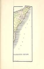
KINCARDINESHIRE
KINCARDINESHIRE
the SW and pass below a bed of lava. As we follow the
coast-line S by Crawton the beds veer round to the W,
and this dip continues to Inchbervie and Gourdon, while
in the neighbourhood of St Cyrus they are inclined to the
N of W. From these data it is evident that the repre-
sentatives of the volcanic series are curving round the
great synclinal fold of Strathmore. Of the sheets of
lava intercalated in this subdivision, the most impor-
tant occurs on the Bruxie and Leys Hills, which can be
traced in a SW direction to the E of Inchbervie. The
thin bands at Crawton, Kinneff, Inchbervie, and Gourdon
are of minor importance.
The members of the volcanic zone are succeeded by
red sandstones and conglomerates with bands of shale,
in which occurs the well-known fish bed at Canterland
(see list of fossils in vol. II., Ord. Gaz., p. 40), and these
beds are overlaid in turn by the friable red marls and
sandstones occupying the centre of the syncline between
Stracathro and Fordoun.
An interesting feature connected with the glaciation
of Kincardineshire is the abnormal trend of the ice-
markings on the shore, compared with the direction
met with on the slopes of the hills. In the higher
reaches of the North fisk, and along the hill slopes as
far as the Auchlee Hill, near Maryculter, the general
trend of the strise is SE and ESE, but along the shore
between Inchbervie and Aberdeen the direction is NNE.
It would seem, therefore, that by some means or other
the ice which radiated from the high grounds of Kin-
cardineshire was compelled to change its course on
reaching the low ground between Stracathro and Stone-
haven. Along this line it moved towards the NE, and
when it reached the coast-line it was deflected still
further towards the NNE and N. It has been suggested
that this remarkable deflection was due to the presence
of the Scandinavian mcr de glace in the North Sea,
which, from its greater size, was capable of overcoming
the seaward motion of the local ice. The evidence
derived from the boulder clay furnishes striking confir-
mation of this northerly movement along the coast.
This deposit, which is spread over the low grounds in
the form of a more or less continuous covering, and
which steals up the valleys draining the hills as a gently
sloping terrace, presents the usual characteristics of the
boulder clay. In the inland area occupied by the Old
Red Sandstone, this deposit contains numerous frag-
ments of the altered crystalline rocks derived from the
slopes of the high grounds of the county, while to the
N of the fault at Stonehaven, in the direction of
Muchalls and Portlethen, striated blocks of red sand-
stone and porphyrite are mingled with fragments of the
underlying rocks in the boulder clay. The blocks of
lava and the red sandstones were derived from the area
lying to the S of the great fault.
At the E end of Strathmore, and along the line of
railway from that point towards Stonehaven, deposits of
gravel and sand are spread over the ground, which are
partly fluviatile and partly due to the melting of the
retreating glaciers. Here and there along the coast
between Stonehaven and St Cyrus patches of stratified
sands, gravels, and clays are met with which may pro-
bably belong to the 100-feet beach.
Soils and Agriculture. — In the Grampian district
there is a large extent of ground simply covered
with heath, waste, or under peat, but along the
southern border matters improve, and there are
stretches of good loam on rock or clay subsoils, while
along both the Feugh and the Dye there are patches
of good rich loam. Along the coast districts the
soil varies considerably. About Muchalls it is thin
and moorish, and the northern district is generally
rough and stony. Some of the land, however, near
Aberdeen is let for dairy farming, and, though stony, is
fertile and commands a good rent. In the southern
district by Benholm, Bervie, and St Cyrus there is good
loam on a subsoil of gravel, clay, or decomposed rock ;
the higher parts are thin. In the Howe district there
are good black and reddish loams, with a subsoil of sand,
gravel, or clay, the gravel lying mostly to the NW, and
394
the clay to the SE. This tract is very fertile. In the
Deeside district, along the N side, there is a good deal of
light sandy soil produced by decomposed granite mixed
with moss, while along the S side the soil varies from a
good black loam to sand, gravel, and clay overlying rock.
Before the middle of last century, agriculture in the
county was but little attended to. ' At that period '
[1761], says Captain Barclay of Ury, in speaking of the
county, ' agriculture was at a very low ebb. My grand-
father, although a most respectable man, had no turn
for improvement, nor had any of his predecessors ; in-
deed, the pursuit of agriculture was generally despised
through the country. But my father seems to have
been a heaven-born improver ; for such was his enthu-
siasm, that a year before his father's death he carried
on his back, all the way from Aberdeen, a bundle of
young trees, which he planted in the den of Ury with
his own hand, sorely to the vexation of the old gentle-
man, who complained that the protecting of the plants
annoyed the people's sheep. Soon after this my father
went to Norfolk, then the great agricultural school of
the kingdom, where he served a regular apprenticeship
to the business, and brought home with him not only
the most improved implements of husbandry, but also
a number of Norfolk ploughmen. At that time the
tenantry were little better than the boors of Germany
and Russia, and the lairds were more inclined to break
each other's heads than to break up the treasures of the
earth. Seeing, then, that preaching doctrines was of
no avail without putting them into practical operation,
he took into his own hands a large surface of about
2000 acres. At that time the estate of Ury was a com-
plete waste, consisting of bogs, baulks, and rigs, every-
where intersected with cairns of stones and moorland.
For twenty years he toiled most indefatigably ; and
during all that time he was never known to be in bed
after five o'clock in the morning, winter or summer.
He was the first man who sowed a turnip in a field, or
artificial grasses, north of the Firth of Forth. During
this period he thoroughly improved 2000 acres, re-
claimed from moor 800, and planted from 1200 to 1500
acres chiefly with forest trees. Gradually his operations
began to attract attention, and be followed by the pro-
prietors and tenantry around, until at last that spirit
of improvement burst forth, which has placed the
agriculture of this part of the country, and Scotland
generally, in the high state of excellence in which we
now find it.' This was in 1838, and the improvement
that has since taken place is equally well marked.
' The area of cultivated land,' says Mr James Macdonald
in his prize report on the agriculture of Forfar and
Kincardine in the Transactions of the Highland and
Agricultural Society for 1881, 'about the commencement
of the century is stated at 74,377 acres, and that under
actual tillage at 45,736, it being estimated that other
28,000 acres were capable of being cultivated. In the
better parts of the county, in the Howe of the Mearns,
and in the parishes of St Cyrus and Benholm, wheat
had been grown as far back as tradition and record
stretched ; while by 1807, barley, oats, peas, beans,
potatoes, and turnips, and sown grasses, were cultivated
with success all over the country. The practice of
leaving land in fallow is said to have been introduced
into the county by Mr Barclay of Urie in 1761. It
spread gradually over the county, and in 1807 the
fallow break was estimated at 2619 acres. ... It
is stated that potatoes were first planted in Kincardine-
shire in 1727 by an old soldier, who had brought some
tubers with him from Ireland to the village of Marykirk,
where he resided for only one year. He raised a good
crop, and it is recorded that, while the villagers were
ready enough to steal the strange plant, " none of them
had the ingenuity to cultivate it after he was gone."
They looked in vain to the stems for the seed. Potatoes
were again introduced into the Mearns in 1760, while
in 1754 turnips were introduced by Mr R. Scott of
Dunninald, and grown by him on the farm of Milton
of Mathers, St Cyrus. In 1764, Mr William Lyall,
farmer in Wattieston, Fordoun, raised about an acre
Set display mode to: Large image | Transcription
Images and transcriptions on this page, including medium image downloads, may be used under the Creative Commons Attribution 4.0 International Licence unless otherwise stated. ![]()
| Gazetteers of Scotland, 1803-1901 > Ordnance gazetteer of Scotland > Volume 4 > (176) Page 394 |
|---|
| Permanent URL | https://digital.nls.uk/97382458 |
|---|
| Attribution and copyright: |
|
|---|---|
| Description | A survey of Scottish topography, statistical, biographical, and historical. Edited by Francis H. Groome. Edinburgh: Thomas C. Jack, 1884-85. "General survey": v.6, 134 p. at end. |
|---|---|
| Shelfmark | Map.Ref.C18 |
| Additional NLS resources: | |
| Description | 20 volumes of the most popular descriptive gazetteers of Scotland, providing a comprehensive geographical encyclopaedia of Scotland in the 19th century. Principal places in Scotland, including towns, counties, castles, glens, antiquities and parishes, are listed alphabetically. Each entry includes detailed historical and geographical information about each place. |
|---|---|