Ordnance gazetteer of Scotland > Volume 3
(95) Page 31
Download files
Complete book:
Individual page:
Thumbnail gallery: Grid view | List view

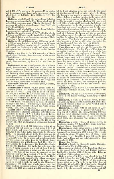
FLADDA
and 9 KE of Portreo town. It measures IJ by J mile,
and is separated from Eaasay only by a narrow strait,
wliich is dry at half-tide. Pop. (1861) 45, (1871) 54,
(1S81) 54.
Fladda, an island of South Uist parish. Outer Hebrides,
Inverness-shire, immediately N" of Eona island, and 2^
miles SE of the nearest part of North Uist island. It
measures 4J miles in circumference. Pop. (1861) 48,
(1871) 76, (1881) 87.
Fladda, a small island of Barra parish, Outer Hebrides,
Inverness-shire, 2 miles S of Vatcrsay.
Fladda, the northernmost of the Treshinish isles in
Kilninian and Kilmore parish, Argyllshire, 3 miles SW
of Treshinish Point, a north-western extremity of Mull.
Its surface is flat and monotonous.
Fladda, an islet of Kilbrandon and Kilchattan parish,
Argyllshire, near Easdale. A lighthouse on it shows
a fixed light visible at the distance of 11 nautical miles,
red toward the Bogha-Nuadh rock, and white toward
the mainland and channel to the S, but masked in other
directions.
Fladda, a flat islet in the NW extremity of Harris
parish, Outer Hebrides, Inverness-shire, in the mouth
of Loch Reasort.
Fladda, an uninhabited pastoral islet of Eilmuir
parish, Inverness-shire, 4J miles SE of Aird Point in
Skye.
Fladdachuain, an uninhabited pastoral islet of Kilmuir
parish, Inverness-shire, 6 miles NW of Aird Point in
Skye. It measures f mile in length and 300 yards in
average breadth ; is clothed with remarkably flue grass ;
had anciently three burying-places ; and also, till a
recent period, retained nine stones of an ancient Cale-
donian stone circle. A one-inch diameter ring, of plaited
gold wires, was found in a moss here, and bought for
the Edinburgh Antiquarian Museum in 1851.
Fladibister, a hamlet in Dunrossness parish, Shetland,
S miles S of Lerwick.
Flanders Moss, a tract of low, flat ground in the NE
of Drymen parisli, SW Stirlingshire, on the southern
bank of the Forth. Lying from 40 to 60 feet above
sea-level, it is believed to have passed from the condi-
tion of a rich alluvial plain to the condition of a bog,
through the overthrow of a forest on it by the Roman
army in the time of Severus ; and has, to a great extent,
in recent times, been reclaimed by means of channel
cuttings to the Forth. It is skirted, to the SE, by the
Forth and Clyde Junction section of the North British
railway. — Ord. Sur., sh. 38, 1871.
Flannan Isles or Seven Hunters, a group of seven
small uninhabited islands in Uig parish, Outer Hebrides,
Ross-shire, 21 miles WNW of Gallon Head in Lewis.
Called by Buchanan Insula: Sacrce, they possess some
monuments, supposed to be religious relics of the ancient
Caledonians, but seemingly as late as the 7th or 8th
centui-y ; and they are frequented by immense flocks of
sea-fowl.
Fleet, a small river of SE Sutherland, rising at an
altitude of 750 feet above sea-level, 2 miles E by S of
Lairg church, and thence winding 16f east-south-east-
ward, till it falls below Little Ferey into the Dornoch
Firth. Its principal affluent is the Cairnaig, and it
intersects or bounds the parishes of Lairg, Rogart, Gol-
spie, and Dornoch. In its upper and middle reaches it
traverses a fine glen called from it Strathfleet ; lower
down it expands into a tidal lagoon. Loch Fleet (3| x 16
miles), similar to the lagoons of the Forfarshire South
Esk and the Findhorn ; but in the last mile above its
mouth it again contracts to a width of from 1 to 2J
fmiongs. Its strath, from a point near- the source all
down to the head of the lagoon, is traversed by the
Sutherland railway, in a gradient of 1 in 84 ; and its
stream, | mile NW of Rogart station, near the High
Rock of Craigmore, is crossed by the railway on a stone
viaduct with a single arch of 55 feet in span. The
lagoon is crossed towards its head by the lyiound, an
emimnkment 995 yards long, which, taking over the
public road for the eastern seaboard of Sutherland, was
completed in 1816 at a cost of £12,500, and is pierced
• FLISK
at its E end with four arches and sluices for the transit
of the river and of tidal currents. Above the Mound
the lagoon is now mainly a swampy flat, covered with
alders ; below, it has been curtailed to the extent of 400
acres, by the reclamation of its bed from the tides ; and
within its mouth it contains a harbour 260 yards broad,
with IS feet of water at ebb tide, perfectly sheltered in all
weather, and serving for the importation of coals, lime,
bone-dust, and general merchandise, and for the expor-
tation of agricultural and distillery produce. The river
is frequented by sea-trout, grilse, and salmon ; and the
neck of it between the lagoon and the sea contains a
fine salmon cast — ' the only spot in the kingdom where
angling for salmon has been successfully practised in
salt water.' The depth of water over the bar at the
river's mouth is IS feet at full spring tide, and 44 feet
at ebb tide.— Ord Sur., shs. 102, 103, 1881-78.
Fleet Street. See Anwoth and Gatehouse.
Fleet, Water of, a small river of Girthon parish, S"W
Kirkcudbrightshire. The Big "Water of Fleet is formed
at a point 2g miles above a 20-arch viaduct of the Port-
patrick railway, by the confluence of Carrouch, Mid,
and Cardson Burns, which all three rise on the eastern
side of Cairnsmoke of Fleet (2331 feet). Thence it
runs 6J miles south-south-eastward along the liirkma-
breck and Anwoth border, till it is joined by the Little
"Water of Fleet, which, issuing from triangular Loch
Fleet (3x2 furl. ; 1120 feet), has a south-by-easterly
course of 7 J miles. After their union, near Castramont,
the stream, as "Water of Fleet, flows 4;j miles south-by-
eastward, and then, a little below Gatehouse, expands,
over the last 3| miles of its course, into the fine estuary
of Fleet Bay. It traverses charming scenery throughout
its middle or lower reaches, and is navigable by small
vessels up to Gatehouse. Its waters are strictly pre-
served, and trout, sea-trout, and herlings are plentiful,
but salmon nowadays are few and far between. — Ord.
Sicr., shs. 4, 5, 1857.
Flemington, a village in Avondale parish, Lanarkshii'e,
containing Strathaven station, and ^ mile NE of the
town.
Flemington, a village in Ayton parish, Berwickshire,
near the North British railway, f mile E by N of Ayton
station.
Flemington, a burn in Newlands parish, Peebles-
shire, running 4;^ miles south-westward, till, after a total
descent of 700 feet, it falls into Lyne "Water, 2 miles S
by E of Eomanno Bridge.
Flemington, an estate, with an old castle, in Aber-
lemno parish, Forfarshire, the property of Patrick Web-
ster, Esq. of Westfield. "The castle, standing 300 yards
E of the parish church, presents a strong and stately
appearance. It was inhabited by the proprietor till
about 1830, and afterwards was occupied by farm-
servants.
Flemington, a collier village, of recent growth, in
Cambuslaug parish, NW Lanarkshire, 1 mile from Cam-
buslang village. Pop. (1881) 691.
Flemington, an estate, with a mansion, in Petty parisli,
NE Inverness-shire, f mile NE of Fort George station.
Separated from Kilravock in 1787, it is now the property
of Lewis Carmichael Urquhart, Esq., of Elgin. Loch
Flemington (4J x IJ furl.) lies 1 mile SSE on the Croy
border, half in Naii'n and half in Inverness shire. — Ord.
Sur., sh. 84, 1876.
Fleurs. See Floors.
Flexfield, a hamlet in Mouswald parish, Dumfries-
shire, 6 J miles E by S of Dumfries.
Flint, an eastern offshoot of the Broughton Heights,
on the mutual border of Stobo and Eirkurd parishes,
Peeblesshire, 4J miles NNE of Rachan Mill. It has an
altitude of 1756 feet above sea-level.
Flisk, a parish of N Fife, whose church to the NE
stands 1 furlong S of the Firth of Tay, 6 miles ENE of
Newburgh station, and 7S NNW of the post-town
Cupar, whilst on its SW border is the little village of
Glenduckie, 4^ mUes E by N of Newburgh. Bounded
NW and N by the Firth of Tay, E by Balmerino, SE by
Creich, S by the Aytonhill section of Abdie, and 8"^
31
Set display mode to: Large image | Transcription
Images and transcriptions on this page, including medium image downloads, may be used under the Creative Commons Attribution 4.0 International Licence unless otherwise stated. ![]()
| Gazetteers of Scotland, 1803-1901 > Ordnance gazetteer of Scotland > Volume 3 > (95) Page 31 |
|---|
| Permanent URL | https://digital.nls.uk/97377594 |
|---|
| Attribution and copyright: |
|
|---|---|

