Ordnance gazetteer of Scotland > Volume 2
(125) Page 379
Download files
Complete book:
Individual page:
Thumbnail gallery: Grid view | List view

DRYMEN
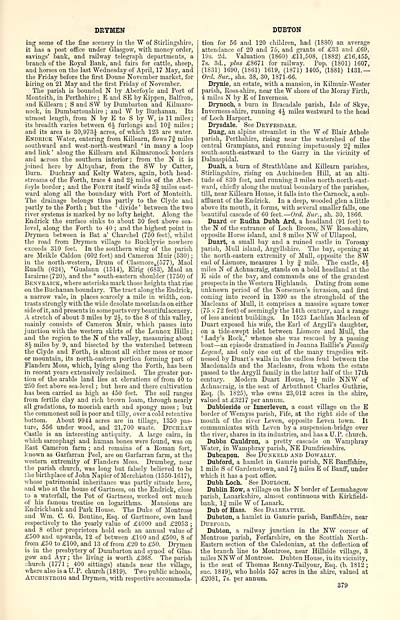
ing some of the fine scenery in the W of Stirlingshire,
it has a post office under Glasgow, with money order,
savings' bank, and railway telegraph departments, a
branch of the Royal Bank, and fairs for cattle, sheep,
and horses on the last Wednesday of April, 17 May, and
the Friday before the first Donne November market, for
hiring on 21 May and the first Friday of November.
The parish is bounded N by Aberfoyle and Port of
Monteith, in Perthshire; E and SE by Kippen, Balfron,
and Eillearn ; S and SW by Dumbarton and Kilmaro-
nock, in Dumbartonshire ; and W by Buchanan. Its
utmost length, from N by E to S by W, is 11 miles;
its breadth varies between 6J furlongs and 10J miles ;
and its area is 30,973| acres, of which 123 are water.
Endrick Water, entering from Killearn, flows 7f miles
southward and west-north-westward 'in many a loop
and link ' along the Killearn and Kilmaronoek borders
and across the southern interior ; from the N it is
joined here by Altquhar, from the SW by Catter,
Burn. Duchray and Kelty Waters, again, both head-
streams of the Forth, trace 4 and 2J miles of the Aber-
foyle border ; and the Forth itself winds 3f miles east-
ward along all the boundary with Port of Monteith.
The drainage belongs thus partly to the Clyde and
partly to the Forth ; but the ' divide ' between the two
river systems is marked by no lofty height. Along the
Endrick the surface sinks to about 30 feet above sea-
level, along the Forth to 40 ; and the highest point in
Drymen between is Bat a' Charchel (750 feet), whilst
the road from Drymen village to Bucklyvie nowhere
exceeds 310 feet. In the southern wing of the parish
are Meikle Caldon (602 feet) and Cameron Muir (530) ;
in the north-western, Drum of Clasmore-(577), Maol
Ruadh (624), *Gualann (1514), Elrig (683), Maol an
Iarairne (720), and the * south-eastern shoulder (1750) of
Benvraick, where asterisks mark those heights that rise
on the Buchanan boundary. The tract along the Endrick,
a narrow vale, in places scarcely a mile in width, con-
trasts strongly with the wide desolate moorlands on either
side of it, and presents in some parts very beautiful scenery.
A stretch of about 3 miles by 2A, to the S of this valley,
mainly consists of Cameron Muir, which passes into
junction with the western skirts of the Lennox Hills ;
and the region to the N of the valley, measuring about
8J miles by 9, and bisected by the watershed between
the Clyde and Forth, is almost all either moss or moor
or mountain, its north-eastern portion forming part of
Flanders Moss, which, lying along the Forth, has been
in recent years extensively reclaimed. The greater por-
tion of the arable land lies at elevations of from 40 to
250 feet above sea-level ; but here and there cultivation
has been carried as higli as 450 feet. The soil ranges
from fertile clay and rich brown loam, through nearly
all gradations, to moorish earth and spongy moss ; but
the commonest soil is poor and tilly, over a cold retentive
bottom. About 9944 acres are in tillage, 1350 pas-
ture, 556 under wood, and 21,700 waste. Duchray
Castle is an interesting antiquity. A large cairn, in
which sarcophagi and human bones were found, was on
East Cameron farm ; and remains of a Roman fort,
known as Garfarran Peel, are on Garfarran farm, at the
western extremity of Flanders Moss. Drumbeg, near
the parish church, was long but falsely believed to be
the birthplace of John Napier of Merchiston (1550-1617),
whose patrimonial inheritance was partly situate here,
and who at the house of Gartness, on the Endrick, close
to a waterfall, the Pot of Gartness, worked out much
of his famous treatise on logarithms. Mansions are
Eudrickbank and Park House. The Duke of Montrose
and Wm. C. G. Bontine, Esq. of Gartmore, own land
respectively to the yearly value of £4000 and £2053 ;
and 8 other proprietors hold each an annual value of
£500 and upwards, 12 of between £100 and £500, 8 of
from £50 to £100, and 13 of from £20 to £50. Drymen
is in the presbytery of Dumbarton and synod of Glas-
gow and Ayr ; the living is worth £368. The parish
church (1771 ; 400 sittings) stands near the village,
where also is a U. P. church (1819). Two public schools,
Aucuintroig and Drymen, with respective aecommoda-
DTJBTON
tion for 56 and 120 children, had (1880) an average
attendance of 20 and 75, and grants of £33 and £69,
19s. 2d. Valuation (1860) £11,508, (1882) £16,455,
7s. 3d., plus £8671 for railway. Pop. (1801) 1607,
(1831) 1690, (1861) 1619, (1871) 1405, (1881) 1431.—
Ord. Sur., shs. 38, 30, 1871-66.
Drynie, an estate, with a mansion, in Kilmuir-Wester
parish, Ross-sliire, near the W shore of the Moray Firth,
4 miles N by E of Inverness.
Drynoch, a burn in Bracadale parish, Isle of Skye,
Inverness-shire, running 4 J miles westward to the head
of Loch Harport.
Drysdale. See Dryfesdale.
Duag, an alpine streamlet in the W of Blair Athole
parish, Perthshire, rising near the watershed of the
central Grampians, and running impetuously 2f miles
south-south-eastward to the Garry in the vicinity of
Dalnaspidal.
Dualt, a burn of Strathblane and Killearn parishes,
Stirlingshire, rising on Auchineden Hill, at an alti-
tude of 830 feet, and running 3 miles north-north-east-
ward, chiefly along the mutual boundary of the parishes,
till, near Killearn House, it falls into the Carnock, a sub-
affluent of the Endrick. In a deep, wooded glen a little
above its mouth, it forms, with several smaller falls, one
beautiful cascade of 60 feet.— Ord. Sur., sh. 30, 1866.
Duard or Rudha Dubh Ard, a headland (91 feet) to
the N of the entrance of Loch Broom, NW Ross-shire,
opposite Horse island, and 8 miles NW of Ullapool.
Duart, a small bay and a ruined castle in Torosay
parish, Mull island, Argyllshire. The bay, opening at
the north-eastern extremity of Mull, opposite the SW
end of Lismore, measures 1 by f rnile. The castle, 4£
miles N of Achnacraig, stands on a bold headland at the
E side of the bay, and commands one of the grandest
prospects in the Western Highlands. Dating from some
unknown period of the Norsemen's invasion, and first
coming into record in 1390 as the stronghold of the
Macleans of Mull, it comprises a massive square tower
(75 x 72 feet) of seemingly the 14th century, and a range
of less ancient buildings. In 1523 Lachlan Maclean of
Duart exposed his wife, the Earl of Argyll's daughter,
on a tide-swept islet between Lismore and Mull, the
' Lady's Rock,' whence she was rescued by a passing
boat — an episode dramatised in Joanna Baillie's Family
Legend, and only one out of the many tragedies wit-
nessed by Duart's walls in the endless feud between the
Macdonalds and the Macleans, from whom the estate
passed to the Argyll family in the latter half of the 17th
century. Modern Duart House, 1J mile NNW of
Achnacraig, is the seat of Arbuthnot Charles Guthrie,
Esq. (b. 1825), who owns 23,012 acres in the shire,
valued at £3217 per annum.
Dubbieside or Innerleven, a coast village on the E
border of Wemyss parish, Fife, at the right side of the
mouth of the river Leven, opposite Leven town. It
communicates with Leven by a suspension-bridge over
the river, shares in its industries, and has a U. P. church.
Dubbs Cauldron, a pretty cascade on Wamphray
Water, in Wamphray parish, NE Dumfriesshire.
Dubcapon. See Dunkeld and Dowally.
Dubford, a hamlet in Gamrie parish, NE Banffshire,
1 mile S of Gardenstown, and 7 J miles E of Banff, under
which it lias a post office.
Dubh Loch. See Douloch.
Dublin Row, a village on the N border of Lesmahagow
parish, Lanarkshire, almost continuous with Kirkfield-
tank, If mile W of Lanark.
Dub of Hass. See Dalbeattie.
Dubston, a hamlet in Gamrie parish, Banffshire, near
Dtjbford.
Dubton, a railway junction in the NW corner of
Montrose parish, Forfarshire, on the Scottish North-
Eastern section of the Caledonian, at the deflection of
the branch line to Montrose, near Hillside village, 3
miles NNW of Montrose. Dubton House, in its vicinity,
is the seat of Thomas Renny-Tailyour, Esq. (b. 1S12 ;
sue. 1849), who holds 557 acres in the shire, valued at
£2081, 7s. per annum.
379
Set display mode to: Large image | Transcription
Images and transcriptions on this page, including medium image downloads, may be used under the Creative Commons Attribution 4.0 International Licence unless otherwise stated. ![]()
| Gazetteers of Scotland, 1803-1901 > Ordnance gazetteer of Scotland > Volume 2 > (125) Page 379 |
|---|
| Permanent URL | https://digital.nls.uk/97374278 |
|---|
| Attribution and copyright: |
|
|---|---|

