Ordnance gazetteer of Scotland > Volume 2
(43) Page 299 - CRA
Download files
Complete book:
Individual page:
Thumbnail gallery: Grid view | List view
CRAIGTHORNHILL
CRAIL
Craigthornhill, an estate, with a mansion, in Glas- I
ford parish, Lanarkshire, 5 miles S by E of Hamilton.
Craigton. See Peteeoulter.
Craigton, a village in Monikie parish, Forfarshire, 5
miles ¥N¥ of Carnoustie, under which it has a post
office.
Craigton, an estate, with an old mansion and a bleach-
field, in the Dumbartonshire section of New Eilpatrick
parish. The mansion stands near the eastern base of
the Eilpatrick Hills, 3J miles NE of Duntocher ; is a
large edifice of 1635 ; and has been converted into
domiciles for the operatives of the bleachfield. The
bleachfield lies on Craigton Burn, a rivulet rising
on the Eilpatrick Hills, and running 3J miles south-
eastward to the Allander ; and contains all appliances
for the best treatment of yarns. A public school
adjoins it.
Craigton, a village in Airlie parish, W Forfarshire, 4
miles SW by W of Eirriemuir. See Airlie.
Craigton, an estate, with a mansion, in Abercorn
parish, Linlithgowshire, 2 miles NW of Winchburgh
station.
Craigullian, a loch in Strathblane parish, SW Stir-
lingshire, If mile WSW of Strathblane village. With
an utmost length and breadth of 3| and 1 J furlongs, it
lies 3S0 feet above sea-level, on a plateau that terminates
in an imposing range of basaltic columns, popularly
called the Pillar Craig.
Craig Vinean, a long, wild, wooded ridge of hill in
Little Dunkeld parish, Perthshire, between the con-
fluent Tay and Bran, culminating 1§ mile W of Inver
village, at 1247 feet above sea-level. Diversified all
over with rocky protuberances, sharp undulations, and
deep hollows, it both contains charming close views
within its own recesses, and commands wide prospects
from its vantage-grounds ; and it forms a romantic
feature in the environs of Dunkeld.
Craigwood, a pyramidal hill (558 feet), with a terrace
around it, in Dunkeld parish, Perthshire, a little to the
E of Dunkeld town. It commands a very fine view of
Dunkeld, and of the mountain-passes diverging thence.
Crail, a seaport town and a parish of the East Neuk
of Fife. A royal and parliamentary burgh, the town is
picturesquely situated in a gully, beyond which the red-
roofed houses rise again. It is 2| miles WSW of Fife
Ness, 10 SE of St Andrews, and 4J NE of Anstruther
station, this being 38| miles NE of Edinburgh ; and on
the Anstruther and St Andrews railway, now (1882) in
course of construction, it is to have a station of its own.
It dates from remote times, figuring so far back as the
first half of the 9th century as a seat of commerce with
the Netherlands, an important fishing and fish-curing
station. And still it retains an old-world character ; still
down towards the sea rise massive, antique dwelling-
houses ; and though the gates are gone, the name of
' ports ' preserves their memory. A royal castle or
palace, the occasional residence of David I. (1124-53),
surmounted the low cliff a little E of the harbour, but,
excepting the merest fragment of a wall, has wholly dis-
appeared. So old, however, is the parish church, that
many have fancied the ' sair Sanct ' himself may have
prayed within its walls — a fancy forbidden by the style
(Second Pointed) of its architecture. As repaired in
1828, it contains 900 sittings, and consists of an aisled
nave, 80 feet long ; a chancel, reduced from 55 to 22§
feet ; and a western tower, with stunted octagonal
spire. _ The SW porch has been destroyed, but the
dedication cross is yet decipherable on the walls, into
which has been built a far more ancient cross, sculp-
tured with animals and other emblems. Till 1517
this church of St Macrubha was held by Haddington
Cistercian nunnery, whose prioress, with Sir William
Myreton, then made it collegiate, for a provost, ten pre-
bendaries, a sacrist, and choristers. On 9 June 1559,
John Enox, attended by a ' rascal multitude,' preached
from its pulpit his Perth 'idolatrous sermon,' with the
usual outcome of pillage and demolition ; and to it in
1648 the Earl of Crawford presented James Sharp, arch-
bishop that was to be. The castle had a chapel dedi-
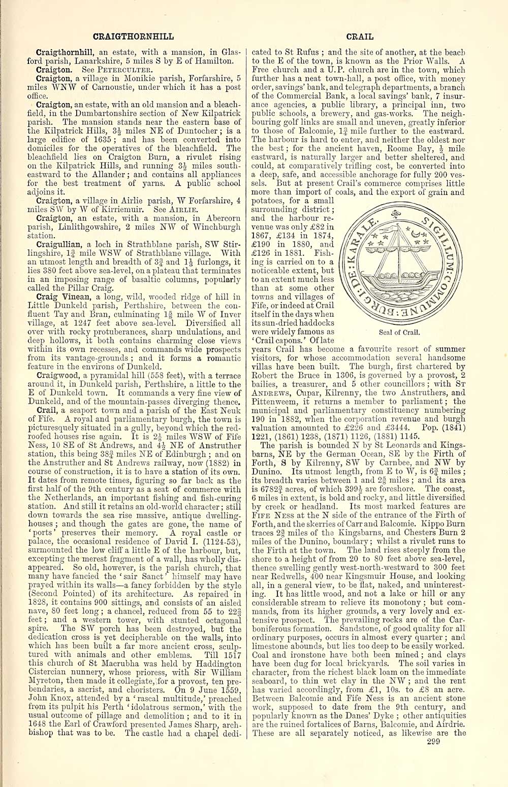
Seal of Crail.
cated to St Rufus ; and the site of another, at the beach
to the E of the town, is known as the Prior Walls. A
Free church and a U.P. church are in the town, which
further has a neat town-hall, a post office, with money
order, savings' bank, and telegraph departments, a branch
of the Commercial Bank, a local savings' bank, 7 insur-
ance agencies, a public library, a principal inn, two
public schools, a brewery, and gas-works. The neigh-
bouring golf links are small and uneven, greatly inferior
to those of Balcomie, lj mile further to the eastward.
The harbour is hard to enter, and neither the oldest nor
the best ; for the ancient haven, Roome Bay, J mile
eastward, is naturally larger and better sheltered, and
could, at comparatively trifling cost, be converted into
a deep, safe, and accessible anchorage for fully 200 ves-
sels. But at present Crail's commerce comprises little
more than import of coals, and the export of grain and
potatoes, for a small
surrounding district ;
and the harbour re-
venue was only £82 in
1867, £134 in 1874,
£190 in 1880, and
£126 in 1881. Fish-
ing is carried on to a
noticeable extent, but
to an extent much less
than at some other
towns and villages of
Fife, or indeed at Crail
itself in the days when
its sun-dried haddocks
were widely famous as
' Crail capons. ' Of late
years Crail has become a favourite resort of summer
visitors, for whose accommodation several handsome
villas have been built. The burgh, first chartered by
Robert the Bruce in 1306, is governed by a provost, 2
bailies, a treasurer, and 5 other councillors ; with St
Andrews, Cupar, Eilrenny, the two Anstruthers, and
Pittenweem, it returns a member to parliament ; the
municipal and parliamentary constituency numbering
190 in 18S2, when the corporation revenue and burgh
valuation amounted to £226 and £3444. Pop. (1841)
1221, (1861) 1238, (1871) 1126, (1881) 1145.
The parish is bounded N by St Leonards and Eings-
barns, NE by the German Ocean, SE by the Firth of
Forth, S by Eilrenny, SW by Carnbee, and NW by
Dunino. Its utmost length, from E to W, is 6J miles ;
its breadth varies between 1 and 2§ miles ; and its area
is 6782f acres, of which 399 J are foreshore. The coast,
6 miles in extent, is bold and rooky, and little diversified
by creek or headland. Its most marked features are
Fife Ness at the N side of the entrance of the Firth of
Forth, and the skerries of Carr and Balcomie. Kippo Burn
traces 2| miles of the Kingsbarns, and Chesters Burn 2
miles of the Dunino, boundary ; whilst a rivulet runs to
the Firth at the town. The land rises steeply from the
shore to a height of from 20 to 80 feet above sea-level,
thence swelling gently west-north-westward to 300 feet
near Redwells, 400 near Eingsmuir House, and looking
all, in a general view, to be flat, naked, and uninterest-
ing. It has little wood, and not a lake or hill or any
considerable stream to relieve its monotony ; but com-
mands, from its higher grounds, a very lovely and ex-
tensive prospect. The prevailing rocks are of the Car-
boniferous formation. Sandstone, of good quality for all
ordinary purposes, occurs in almost every quarter ; and
limestone abounds, but lies too deep to be easily worked.
Coal and ironstone have both been mined ; and clays
have been dug for local brickyards. The soil varies in
character, from the richest black loam on the immediate
seaboard, to thin wet clay in the NW ; and the rent
has varied accordingly, from £1, 10s. to £8 an acre.
Between Balcomie and Fife Ness is an ancient stone
work, supposed to date from the 9th century, and
popularly known as the Danes' Dyke ; other antiquities
are the ruined fortalices of Barns, Balcomie, and Airdrie.
These are all separately noticed, as likewise are the
299
CRAIL
Craigthornhill, an estate, with a mansion, in Glas- I
ford parish, Lanarkshire, 5 miles S by E of Hamilton.
Craigton. See Peteeoulter.
Craigton, a village in Monikie parish, Forfarshire, 5
miles ¥N¥ of Carnoustie, under which it has a post
office.
Craigton, an estate, with an old mansion and a bleach-
field, in the Dumbartonshire section of New Eilpatrick
parish. The mansion stands near the eastern base of
the Eilpatrick Hills, 3J miles NE of Duntocher ; is a
large edifice of 1635 ; and has been converted into
domiciles for the operatives of the bleachfield. The
bleachfield lies on Craigton Burn, a rivulet rising
on the Eilpatrick Hills, and running 3J miles south-
eastward to the Allander ; and contains all appliances
for the best treatment of yarns. A public school
adjoins it.
Craigton, a village in Airlie parish, W Forfarshire, 4
miles SW by W of Eirriemuir. See Airlie.
Craigton, an estate, with a mansion, in Abercorn
parish, Linlithgowshire, 2 miles NW of Winchburgh
station.
Craigullian, a loch in Strathblane parish, SW Stir-
lingshire, If mile WSW of Strathblane village. With
an utmost length and breadth of 3| and 1 J furlongs, it
lies 3S0 feet above sea-level, on a plateau that terminates
in an imposing range of basaltic columns, popularly
called the Pillar Craig.
Craig Vinean, a long, wild, wooded ridge of hill in
Little Dunkeld parish, Perthshire, between the con-
fluent Tay and Bran, culminating 1§ mile W of Inver
village, at 1247 feet above sea-level. Diversified all
over with rocky protuberances, sharp undulations, and
deep hollows, it both contains charming close views
within its own recesses, and commands wide prospects
from its vantage-grounds ; and it forms a romantic
feature in the environs of Dunkeld.
Craigwood, a pyramidal hill (558 feet), with a terrace
around it, in Dunkeld parish, Perthshire, a little to the
E of Dunkeld town. It commands a very fine view of
Dunkeld, and of the mountain-passes diverging thence.
Crail, a seaport town and a parish of the East Neuk
of Fife. A royal and parliamentary burgh, the town is
picturesquely situated in a gully, beyond which the red-
roofed houses rise again. It is 2| miles WSW of Fife
Ness, 10 SE of St Andrews, and 4J NE of Anstruther
station, this being 38| miles NE of Edinburgh ; and on
the Anstruther and St Andrews railway, now (1882) in
course of construction, it is to have a station of its own.
It dates from remote times, figuring so far back as the
first half of the 9th century as a seat of commerce with
the Netherlands, an important fishing and fish-curing
station. And still it retains an old-world character ; still
down towards the sea rise massive, antique dwelling-
houses ; and though the gates are gone, the name of
' ports ' preserves their memory. A royal castle or
palace, the occasional residence of David I. (1124-53),
surmounted the low cliff a little E of the harbour, but,
excepting the merest fragment of a wall, has wholly dis-
appeared. So old, however, is the parish church, that
many have fancied the ' sair Sanct ' himself may have
prayed within its walls — a fancy forbidden by the style
(Second Pointed) of its architecture. As repaired in
1828, it contains 900 sittings, and consists of an aisled
nave, 80 feet long ; a chancel, reduced from 55 to 22§
feet ; and a western tower, with stunted octagonal
spire. _ The SW porch has been destroyed, but the
dedication cross is yet decipherable on the walls, into
which has been built a far more ancient cross, sculp-
tured with animals and other emblems. Till 1517
this church of St Macrubha was held by Haddington
Cistercian nunnery, whose prioress, with Sir William
Myreton, then made it collegiate, for a provost, ten pre-
bendaries, a sacrist, and choristers. On 9 June 1559,
John Enox, attended by a ' rascal multitude,' preached
from its pulpit his Perth 'idolatrous sermon,' with the
usual outcome of pillage and demolition ; and to it in
1648 the Earl of Crawford presented James Sharp, arch-
bishop that was to be. The castle had a chapel dedi-
Seal of Crail.
cated to St Rufus ; and the site of another, at the beach
to the E of the town, is known as the Prior Walls. A
Free church and a U.P. church are in the town, which
further has a neat town-hall, a post office, with money
order, savings' bank, and telegraph departments, a branch
of the Commercial Bank, a local savings' bank, 7 insur-
ance agencies, a public library, a principal inn, two
public schools, a brewery, and gas-works. The neigh-
bouring golf links are small and uneven, greatly inferior
to those of Balcomie, lj mile further to the eastward.
The harbour is hard to enter, and neither the oldest nor
the best ; for the ancient haven, Roome Bay, J mile
eastward, is naturally larger and better sheltered, and
could, at comparatively trifling cost, be converted into
a deep, safe, and accessible anchorage for fully 200 ves-
sels. But at present Crail's commerce comprises little
more than import of coals, and the export of grain and
potatoes, for a small
surrounding district ;
and the harbour re-
venue was only £82 in
1867, £134 in 1874,
£190 in 1880, and
£126 in 1881. Fish-
ing is carried on to a
noticeable extent, but
to an extent much less
than at some other
towns and villages of
Fife, or indeed at Crail
itself in the days when
its sun-dried haddocks
were widely famous as
' Crail capons. ' Of late
years Crail has become a favourite resort of summer
visitors, for whose accommodation several handsome
villas have been built. The burgh, first chartered by
Robert the Bruce in 1306, is governed by a provost, 2
bailies, a treasurer, and 5 other councillors ; with St
Andrews, Cupar, Eilrenny, the two Anstruthers, and
Pittenweem, it returns a member to parliament ; the
municipal and parliamentary constituency numbering
190 in 18S2, when the corporation revenue and burgh
valuation amounted to £226 and £3444. Pop. (1841)
1221, (1861) 1238, (1871) 1126, (1881) 1145.
The parish is bounded N by St Leonards and Eings-
barns, NE by the German Ocean, SE by the Firth of
Forth, S by Eilrenny, SW by Carnbee, and NW by
Dunino. Its utmost length, from E to W, is 6J miles ;
its breadth varies between 1 and 2§ miles ; and its area
is 6782f acres, of which 399 J are foreshore. The coast,
6 miles in extent, is bold and rooky, and little diversified
by creek or headland. Its most marked features are
Fife Ness at the N side of the entrance of the Firth of
Forth, and the skerries of Carr and Balcomie. Kippo Burn
traces 2| miles of the Kingsbarns, and Chesters Burn 2
miles of the Dunino, boundary ; whilst a rivulet runs to
the Firth at the town. The land rises steeply from the
shore to a height of from 20 to 80 feet above sea-level,
thence swelling gently west-north-westward to 300 feet
near Redwells, 400 near Eingsmuir House, and looking
all, in a general view, to be flat, naked, and uninterest-
ing. It has little wood, and not a lake or hill or any
considerable stream to relieve its monotony ; but com-
mands, from its higher grounds, a very lovely and ex-
tensive prospect. The prevailing rocks are of the Car-
boniferous formation. Sandstone, of good quality for all
ordinary purposes, occurs in almost every quarter ; and
limestone abounds, but lies too deep to be easily worked.
Coal and ironstone have both been mined ; and clays
have been dug for local brickyards. The soil varies in
character, from the richest black loam on the immediate
seaboard, to thin wet clay in the NW ; and the rent
has varied accordingly, from £1, 10s. to £8 an acre.
Between Balcomie and Fife Ness is an ancient stone
work, supposed to date from the 9th century, and
popularly known as the Danes' Dyke ; other antiquities
are the ruined fortalices of Barns, Balcomie, and Airdrie.
These are all separately noticed, as likewise are the
299
Set display mode to: Large image | Transcription
Images and transcriptions on this page, including medium image downloads, may be used under the Creative Commons Attribution 4.0 International Licence unless otherwise stated. ![]()
| Gazetteers of Scotland, 1803-1901 > Ordnance gazetteer of Scotland > Volume 2 > (43) Page 299 - CRA |
|---|
| Permanent URL | https://digital.nls.uk/97373294 |
|---|
| Attribution and copyright: |
|
|---|---|
| Description | A survey of Scottish topography, statistical, biographical, and historical. Edited by Francis H. Groome. Edinburgh: Thomas C. Jack, 1884-85. "General survey": v.6, 134 p. at end. |
|---|---|
| Shelfmark | Map.Ref.C18 |
| Additional NLS resources: | |
| Description | 20 volumes of the most popular descriptive gazetteers of Scotland, providing a comprehensive geographical encyclopaedia of Scotland in the 19th century. Principal places in Scotland, including towns, counties, castles, glens, antiquities and parishes, are listed alphabetically. Each entry includes detailed historical and geographical information about each place. |
|---|---|