Ordnance gazetteer of Scotland > Volume 1
(304) Page 266 - CLE
Download files
Complete book:
Individual page:
Thumbnail gallery: Grid view | List view

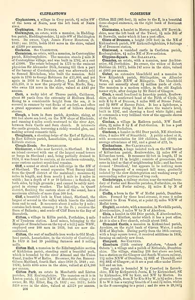
CLEPHANTOWN
Clephantown, a village in Croy parish, 6$ miles SW
of the town of Nairn, near the left bank of Nairn
river.
Clephington. See Dundee.
Clerkington, an estate, with a mansion, in Hadding-
ton parish, Haddingtonshire, 1| mile SW of Haddington
town. Its owner, Capt. James Flower Houstonn (b.
1842 ; sue. 1879), holds 5148 acres in the shire, valued
at £2268 per annum.
Clerkston. See Clarkston.
Clermiston, an estate, with a mansion, in Corstorphine
parish, Edinburghshire. The mansion stands f mile N
of Corstorphine village, and was built in 1792, at a cost
of £3000. The estate belonged in 1771 to the eminent
physician Sir Alexander Dick, forming till then a part
of the barony of Corstorphine, and was afterwards sold
to Samuel Mitchelson, who built the mansion. Sold
again in 1795 to George Robinson for £11,000, and yet
again in 1836 to Francis Jeffrey, Lord Jeffrey, for
£15,250, it is now the property of "Win. Macfle, Esq.,
■who owns 124 acres in the shire, valued at £443 per
annum.
Clett, a rocky islet of Thurso parish, Caithness,
about 80 yards from the extremity of Holburn Head.
Rising to a considerable height from the sea, it is
covered in summer by vast flocks of sea-fowl, and offers
a grand appearance amid the surf of billows during
storms.
Cleugh, a bum in Sorn parish, Ayrshire, rising, at
980 feet above sea-level, on the NW slope of Blackside,
and running 4 miles south-westward to the river Ayr,
between Sorn Castle and Sorn church. It intersects
the castle grounds, traversing a richly-wooded glen, and
making several romantic falls.
Cleughearn, a shooting-lodge of the Earl of Eglinton,
in East Kilbride parish, Lanarkshire, 52 miles S of East
Kilbride station.
Cleugh-Heads. See Applegarth.
Clickamier, a lake near Lerwick, in Shetland. It has
an island crowned with one of the largest round towers
or burgs in Shetland ; and, being partially drained in
1S74, it was found to contain, at its southern extremity,
some curious ancient sepulchral remains.
Cliff, a sound or strait and a hill-ridge in the S"W of
of Shetland. The sound separates West Barray island
from the Quarff district of the mainland ; measures 6J
miles in length, and from nearly | mile to 2 miles in
width ; has a depth of 8 or 10 fathoms ; is flanked, on
both sides, by high grounds ; and cannot be safely navi-
gated in stormy weather. The hill-ridge, in Quarff
district, flanking the eastern shore of the sound, has a
maximum altitude of more than 500 feet.
Cliff, a beautiful loch in Unst island, Shetland, the
largest of several in the valley which bisects the island
from end to end. It measures about 3 miles by J mile ;
contains loch-trout, running 3 to the lb. ; receives the
Burn of Baliasta ; and sends off Cliff Burn to the Bay of
Burrafirth.
Clifton, a village in Killin parish, Perthshire, \ mile
N of Tyndrum station. Lead mines, belonging to the
Marquis of Breadalbane on the top of a hill J mile WSW,
employed over 100 men in 1839, but are now dis-
continued.
Clifton, the seat of malleable iron works in Old Monk-
land parish, Lanarkshire, in the vicinity of Coatbridge.
In 1879 it had 19 puddling furnaces and 3 rolling
mills.
Clifton Hall, a mansion in the Edinburghshire section
of Kirkliston parish, standing amid a beautiful park,
which is bounded by the river Almond and the Union
Canal, 2 miles W of Ratho. Its owner, Sir Jas. Ramsay -
Gibson-Maitland, fourth Bart, since 1818 (b. 1848 ; sue.
1876), holds 4505 acres in the shire, valued at £14,246
per annum.
Clifton Park, an estate in Morebattle and Linton
parishes, NE Roxburghshire. The mansion on it is in
Linton parish, \\ mile NNW of Morebattle village ; its
owner, Rt. Hy. Elliot, Esq. (b. 1837 ; sue. 1873), holds
5258 acres in the shire, valued at £5178 per annum.
266
CLOSEBURN
Clifton Hill (905 feet), 3J miles to the E, is a beautiful
dome-shaped eminence, on the right bank of Bowmont
Water.
Clintmains, a hamlet in Merton parish, SW Berwick-
shire, near the left bank of the Tweed, 1J mile NE of
St Boswells, under which it has a post office.
Clints of Drumore, a height (950 feet) in the NE of
Kirkmabreck parish, SW Kirkcudbrightshire, 9 furlongs
N of Drumore station.
Clintwood, a vanished castle in Castleton parish,
Roxburghshire, 4J miles NE of Newcastleton.
Clippens-Square. See Balaklava.
Cloanden, an estate, with a mansion, near Auchter-
arder, SE Perthshire. Its owner, the widow of Robert
Haldane (d. 1877), holds 747 acres in the shire, valued
at £683 per annum.
Clober, an extensive bleachfield and a mansion in
New Kilpatrick parish, Stirlingshire, on Allander
Water, £ mile NNW of Milngavie. The bleachfield
turns out annually about 3J million yards of cloth.
The mansion is a modern edifice, in the old English
manor style, after designs by Mr Baird of Glasgow.
Cloch, a small headland in Innerkip parish, Renfrew-
shire, at the southward bend of the Firth of Clyde, If
mile E by S of Dunoon, 3 miles SSE of Strone Point,
and 3§ SSW of Barons Point. It has a lighthouse, a
circular tower rising 76 feet above the water's level,
built in 1797, and showing a fixed white light ; and
it commands a very brilliant view of the opposite shores
of the Firth.
Clochan, a village in Rathven parish, NW Banff-
shire, 2-J miles S by E of Port-Gordon. It has a post
office under Fochabers.
Clochcan, a hamlet in Old Deer parish, NE Aberdeen-
shire, 3 miles SW of Stuartfield. A public school at it,
with accommodation for 110 children, had (1880) an
average attendance of 107, and a grant of £72, Is.
Clochnabane. See Clachnaben.
Clochoderiek, a huge isolated rock on the SW border
of Kilbarchan parish, Renfrewshire, 2J miles SW of
Kilbarchan town. It measures 22 feet in length, 17 in
breadth, and 12 in height ; consists of greenstone, the
same in kind as that of neighbouring hills ; and has been
deemed ' Druidical,' but appears to be nothing more
than a fragment of a compact hill mass, gradually
isolated by the slow disintegration and washing away of
surrounding softer portions of trap rock.
Clocksbriggs, a railway station near the mutual boun-
dary of Forfar and Rescobie parishes, Forfarshire, on the
Arbroath and Forfar railway, 2^ miles E by N of
Forfar.
Cloffin, a burn in the W of Moffat parish, Dumfries-
shire. Formed by three head-streams, it runs 2 miles
eastward to Evan Water, at a point 2J miles WNW of
Moffat town.
Cloghill, an estate, with a mansion, in Newhills parish,
Aberdeenshire, 5 miles W by N of Aberdeen.
Clola, a hamlet in Old Deer parish, E Aberdeenshire,
3 miles S of Mintlaw, under which it has a post office.
At it is also a Free church, rebuilt about 1863.
Cloncaird Castle, a mansion in Kirkmichael parish,
Ayrshire, on the right bank of Girvan Water, 5 miles
ESE of Maybole. Dating partly from the 16th century,
with a huge square tower, it received additions in 1814,
forming an entirely new front.
Clonyard. See Colvend.
Closeburn (12th century Kylosbern, ' church of
Osbern '), a village and a parish of Nithsdale, Dumfries-
shire. The village, standing 238 feet above sea-level,
has a station on the Glasgow and South-Western railway,
llj miles NNW of Dumfries, 2| SSE of Thornhill, and
80 J SSE of Glasgow; at it are a post office under Thorn-
hill and an inn.
The parish is bounded N by Crawford in Lanark-
shire, NE by Kirkpatrick-Juxta, E by Kirkmichael, SE
by Kirkmahoe, SW by Keir, and NW by Morton. Its
greatest length, from N by E to S by W, is 9| miles ; from
E to W it has a varying breadth of 5 and 7J miles, whilst
in the S converging to a point ; and its area is 29,347J
Set display mode to: Large image | Transcription
Images and transcriptions on this page, including medium image downloads, may be used under the Creative Commons Attribution 4.0 International Licence unless otherwise stated. ![]()
| Gazetteers of Scotland, 1803-1901 > Ordnance gazetteer of Scotland > Volume 1 > (304) Page 266 - CLE |
|---|
| Permanent URL | https://digital.nls.uk/97372414 |
|---|
| Attribution and copyright: |
|
|---|---|

