Ordnance gazetteer of Scotland > Volume 1
(188) Page 152
Download files
Complete book:
Individual page:
Thumbnail gallery: Grid view | List view
BERWICK, NORTH
at that time Bishop of Oxford ; and the Roman Catholic
church of Our Lady, an Early Decorated edifice of 1879.
North Berwick owes its incorporation as a royal burgh
to a charter of Robert III. (1390-1406), confirmed by
James VI. in 1568, and it is governed by a provost, a
bailie, a treasurer, 6 councillors, 2 town-clerks, and a
procurator-fiscal ; whilst since the Union it has united
with Haddington, Dunbar, Jedburgh, and Lauder in
returning one member to parliament, its parliamentary
constituency numbering 212 and its municipal 217 in
1881, when its corporation revenue amounted to £317,
and its valuation to £9273, lis. Pop. of parliamentary
burgh (1851) 863, (1861) 1164, (1871) 1399, of whom
900 were in the royal burgh, (1881) 1698.
The parish comprises, besides four or five tinier islets,
the barren greenstone island of Craigleith, 5 furlongs in
circumference, 80 feet high, and 7 furlongs N of the
harbour ; and it contests with WMtekirk a claim to in-
clude the Bass, which rises 313 feet. Bounded N by
the Firth of Forth, E and SE by WMtekirk, S by Pres-
tonkirk, and SW and W by Dirleton, it has a length
from E to W of from 2 J to 3 J miles, a width from N to
S of from 2-J to 3 miles, and an area of 5372f acres, of
which 304 are foreshore and 1J water. The seaboard
must be fully 5 miles long, reckoning all ins and outs ;
and to the E, from Canty Bay to Tautallon, is bold and
rocky, rapidly rising to over 100 feet. Inland, the sur-
face presents one and one only prominent feature, 'North
Berwick Law, with cone of green,' whose height* and
isolation make it conspicuous for 20 miles and more ;
whilst from its summit, gained by a zigzag or M road,
and crowned by a ruined signal station and by the jaw-
bones of a whale, one looks away southward to the Lam-
mermuirs, west-south-westward to Arthur's Seat and the
Pentlands, north-westward to the Lomond Hills in Fife.
And round its western and northern base the little Mill
Burn wanders, on through a wooded and secluded glen,
'The Ladies' Walk,' to Milsey Bay. The interesting
geology of this parish is thus epitomised by Mr Ferrier :
— ' North Berwick stands in a trap district, extending
along the coast from Aberlady Bay to Dunbar, and in-
terposed between two coalfields, with isolated patches of
Old Red sandstone here and there, which, having been
upheaved by volcanic forces from their original site,
have not been carried away by denudating agencies.
But although hills of trap properly so called are numerous
■ — greenstone, basalt, clinkstone, or porphyry, a good
quarry of which last on the S side of the Law has fur-
nished the town's materials — and though the neighbour-
ing islets are all of this character, the prevailing rock of
the district is trap-tuff, of which Hugh Miller says it is
"a curiously compounded rock, evidently of Plutonic
origin, and yet as regularly stratified as almost any rock
belonging to the Neptunian series. " ' The soils, which
range from deep free loam and stiff alluvial clay to
stretches of the lightest sand along the coast, are highly
fertile and well cultivated, steam-ploughing having been
introduced to the Lothians on Ferrygate farm. Remains
of a crannoge or lake-village at Balgone, and the desolate
shell of Fenton Tower are as nothing compared with
Tantallon Castle, whose annals are closely connected
with those of the parish, North Berwick barony having
passed under Robert II. from the Earls of Fife to the
Douglases, and been sold with the castle by the Marquis
of Douglas to Sir Hew Dabymple, Bart. (ere. 1697),
third son of the first Viscount Stair, and himself Lord
President of the Court of Session. His fifth descendant,
Sir Hew Hamilton-Dalrymple of Leucine House, divides
much of the property with Sir George Grant Suttie, sixth
Bart, since 1702, of Balgone and Prestongrange, the
Dalrymple estate within the shire comprising 3039 and
the Suttie 878S acres, of a respective value per annum
of £8S57 and £10,958. Leuchie and Balgone stand amid
finely-wooded parks, 2 and 2| miles SSW of the town ;
the former, dating from 1777, has been almost rebuilt
* A correspondent of the Scotsman (June 10, 18S0) drew atten-
tion to the fact that this height is given, not at 612, but as 940
feet, in well-nigh every work on Scottish topography. The fons
er/oris seems to have been the New Statistical.
152
BERWICKSHIRE
by its present owner. One other proprietor holds a
yearly value of £500 and upwards, and 7 hold each be-
tween £100 and £500, 17 between £50 and £100, and
67 between £20 and £50. North Berwick is in the
presbytery of Haddington and synod of Lothian and
Tweeddale ; the living is worth £510. A public school
at the town, and a subscription school at Halfland Barns,
3 miles ESE, with respective accommodation for 400 and
68 children, had (1879) an average attendance of 250 and
49, and grants of £233, 18s. and £52, 0s. 6d. Valuation,
exclusive of burgh, (1881) £17,510, 14s. Total pop.
(1801) 1583, (1811) 1727, (1821) 1694, (1831) 1824,
(1841) 1708, (1851) 1643, (1861) 2071, (1871) 2373,
(1S81) 26S6. —Ord. Sur., shs. 41, 33, 1857-63. See G.
Fender's North Berwick and its Vicinity (10th ed. 1881).
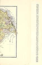
Berwickshire, the most south-easterly county of Scot-
land. It takes its name from Berwick-upon-Tweed,
which anciently belonged to Scotland, and was this
county's capital ; but it originally bore the name of
Merse, and it probably took that name from its situation
as a march or border district. Merse, however, or March,
or the Merse, seems to have included a considerable
portion of the eastern lowlands of Teviotdale ; and it
gave the name of March, or the castle of the March or
Merse, to Roxburgh Castle. The name Berwickshire,
when once assumed, became a fixture for all the county,
except the portion beneath and around Berwick which,
ceded to England, was eventually constituted a separate
jurisdiction ; but the name Merse, on the other hand,
partly became a loose descriptive designation for all the
low country lying between the Tweed and the Lammer-
muirs, and extending up the right bank of the Tweed
to the Eildon Hills, and partly sank into the designa-
tion of only so much of that region as lies E of the Rox-
burghshire boundary. Two other names, Lammermuir
and Lauderdale, are now and have long been applied to
respectively the eastern and the western sections of the
other or hilly portion of Berwickshire ; but they have
always been ill-defined as to the limit-line dividing them
from each other, or dividing either or both from the
Merse. The three divisions of the county, Merse, Lam-
mermuir, and Lauderdale, are separately noticed.
Berwickshire is bounded N by Haddingtonshire, NE
and E by the German Ocean, SE by Berwick-upon-Tweed,
Northumberland, and Roxburghshire, W by Roxburgh
and Edinburgh shires. The northern boundary is a fit-
ful line, partly along the watershed of the Lammermuir
Hills, partly far down their declivities, and isolates or
includes a detached portion of one of the Haddington-
shire parishes ; the south-eastern boundary is partly an
artificial line drawn from the coast to the Tweed around
the quondam liberties of Berwick, and mainly the Tweed
itself up to a point 1 J mile W of Birgham ; the southern
boundary, from the point If mile W of Birgham, on-
ward .to the south-eastern extremity of Mertoun parish
is an exceedingly tortuous artificial line, and all round
the separation of Mertoun parish from Roxburghshire is
the river Tweed ; and the western boundary is Leader
Water for 4£ miles, Cockum Water for 2J miles, Crook -
ston Burn for 3| miles, and artificial lines over most of
the' intermediate and further distances. The greatest
length of the county is 29J miles from E to W ; the
greatest breadth is 20g miles from N to S ; and the area
is 294,804f acres of land, 1557-J acres of water, and 799
acres of foreshore — in all, 464 square miles.
The coast, exclusive of minor sinuosities, measures
about 19 miles in length ; trends, in general direction,
from NW to SE ; makes two considerable projections, in
the form of promontories, around Fast Castle and St Abb's
Head ; has two small bays at Coldingham and Eyemouth,
but no other landing-places, except two or three acces-
sible only to fishing boats or similar very small craft ;
and almost entirely consists of bold rocky precipices,
ranging in altitude from 117 to 52S feet above the sea.
The surface of the southern or Merse division of the in-
terior, amounting to about 100,220 acres, is all low
country, and unites with the contiguous Merse section
of Roxburghshire to form the largest plain in Scotland.
But, though presenting a general uniformity of level, it
at that time Bishop of Oxford ; and the Roman Catholic
church of Our Lady, an Early Decorated edifice of 1879.
North Berwick owes its incorporation as a royal burgh
to a charter of Robert III. (1390-1406), confirmed by
James VI. in 1568, and it is governed by a provost, a
bailie, a treasurer, 6 councillors, 2 town-clerks, and a
procurator-fiscal ; whilst since the Union it has united
with Haddington, Dunbar, Jedburgh, and Lauder in
returning one member to parliament, its parliamentary
constituency numbering 212 and its municipal 217 in
1881, when its corporation revenue amounted to £317,
and its valuation to £9273, lis. Pop. of parliamentary
burgh (1851) 863, (1861) 1164, (1871) 1399, of whom
900 were in the royal burgh, (1881) 1698.
The parish comprises, besides four or five tinier islets,
the barren greenstone island of Craigleith, 5 furlongs in
circumference, 80 feet high, and 7 furlongs N of the
harbour ; and it contests with WMtekirk a claim to in-
clude the Bass, which rises 313 feet. Bounded N by
the Firth of Forth, E and SE by WMtekirk, S by Pres-
tonkirk, and SW and W by Dirleton, it has a length
from E to W of from 2 J to 3 J miles, a width from N to
S of from 2-J to 3 miles, and an area of 5372f acres, of
which 304 are foreshore and 1J water. The seaboard
must be fully 5 miles long, reckoning all ins and outs ;
and to the E, from Canty Bay to Tautallon, is bold and
rocky, rapidly rising to over 100 feet. Inland, the sur-
face presents one and one only prominent feature, 'North
Berwick Law, with cone of green,' whose height* and
isolation make it conspicuous for 20 miles and more ;
whilst from its summit, gained by a zigzag or M road,
and crowned by a ruined signal station and by the jaw-
bones of a whale, one looks away southward to the Lam-
mermuirs, west-south-westward to Arthur's Seat and the
Pentlands, north-westward to the Lomond Hills in Fife.
And round its western and northern base the little Mill
Burn wanders, on through a wooded and secluded glen,
'The Ladies' Walk,' to Milsey Bay. The interesting
geology of this parish is thus epitomised by Mr Ferrier :
— ' North Berwick stands in a trap district, extending
along the coast from Aberlady Bay to Dunbar, and in-
terposed between two coalfields, with isolated patches of
Old Red sandstone here and there, which, having been
upheaved by volcanic forces from their original site,
have not been carried away by denudating agencies.
But although hills of trap properly so called are numerous
■ — greenstone, basalt, clinkstone, or porphyry, a good
quarry of which last on the S side of the Law has fur-
nished the town's materials — and though the neighbour-
ing islets are all of this character, the prevailing rock of
the district is trap-tuff, of which Hugh Miller says it is
"a curiously compounded rock, evidently of Plutonic
origin, and yet as regularly stratified as almost any rock
belonging to the Neptunian series. " ' The soils, which
range from deep free loam and stiff alluvial clay to
stretches of the lightest sand along the coast, are highly
fertile and well cultivated, steam-ploughing having been
introduced to the Lothians on Ferrygate farm. Remains
of a crannoge or lake-village at Balgone, and the desolate
shell of Fenton Tower are as nothing compared with
Tantallon Castle, whose annals are closely connected
with those of the parish, North Berwick barony having
passed under Robert II. from the Earls of Fife to the
Douglases, and been sold with the castle by the Marquis
of Douglas to Sir Hew Dabymple, Bart. (ere. 1697),
third son of the first Viscount Stair, and himself Lord
President of the Court of Session. His fifth descendant,
Sir Hew Hamilton-Dalrymple of Leucine House, divides
much of the property with Sir George Grant Suttie, sixth
Bart, since 1702, of Balgone and Prestongrange, the
Dalrymple estate within the shire comprising 3039 and
the Suttie 878S acres, of a respective value per annum
of £8S57 and £10,958. Leuchie and Balgone stand amid
finely-wooded parks, 2 and 2| miles SSW of the town ;
the former, dating from 1777, has been almost rebuilt
* A correspondent of the Scotsman (June 10, 18S0) drew atten-
tion to the fact that this height is given, not at 612, but as 940
feet, in well-nigh every work on Scottish topography. The fons
er/oris seems to have been the New Statistical.
152
BERWICKSHIRE
by its present owner. One other proprietor holds a
yearly value of £500 and upwards, and 7 hold each be-
tween £100 and £500, 17 between £50 and £100, and
67 between £20 and £50. North Berwick is in the
presbytery of Haddington and synod of Lothian and
Tweeddale ; the living is worth £510. A public school
at the town, and a subscription school at Halfland Barns,
3 miles ESE, with respective accommodation for 400 and
68 children, had (1879) an average attendance of 250 and
49, and grants of £233, 18s. and £52, 0s. 6d. Valuation,
exclusive of burgh, (1881) £17,510, 14s. Total pop.
(1801) 1583, (1811) 1727, (1821) 1694, (1831) 1824,
(1841) 1708, (1851) 1643, (1861) 2071, (1871) 2373,
(1S81) 26S6. —Ord. Sur., shs. 41, 33, 1857-63. See G.
Fender's North Berwick and its Vicinity (10th ed. 1881).
Berwickshire, the most south-easterly county of Scot-
land. It takes its name from Berwick-upon-Tweed,
which anciently belonged to Scotland, and was this
county's capital ; but it originally bore the name of
Merse, and it probably took that name from its situation
as a march or border district. Merse, however, or March,
or the Merse, seems to have included a considerable
portion of the eastern lowlands of Teviotdale ; and it
gave the name of March, or the castle of the March or
Merse, to Roxburgh Castle. The name Berwickshire,
when once assumed, became a fixture for all the county,
except the portion beneath and around Berwick which,
ceded to England, was eventually constituted a separate
jurisdiction ; but the name Merse, on the other hand,
partly became a loose descriptive designation for all the
low country lying between the Tweed and the Lammer-
muirs, and extending up the right bank of the Tweed
to the Eildon Hills, and partly sank into the designa-
tion of only so much of that region as lies E of the Rox-
burghshire boundary. Two other names, Lammermuir
and Lauderdale, are now and have long been applied to
respectively the eastern and the western sections of the
other or hilly portion of Berwickshire ; but they have
always been ill-defined as to the limit-line dividing them
from each other, or dividing either or both from the
Merse. The three divisions of the county, Merse, Lam-
mermuir, and Lauderdale, are separately noticed.
Berwickshire is bounded N by Haddingtonshire, NE
and E by the German Ocean, SE by Berwick-upon-Tweed,
Northumberland, and Roxburghshire, W by Roxburgh
and Edinburgh shires. The northern boundary is a fit-
ful line, partly along the watershed of the Lammermuir
Hills, partly far down their declivities, and isolates or
includes a detached portion of one of the Haddington-
shire parishes ; the south-eastern boundary is partly an
artificial line drawn from the coast to the Tweed around
the quondam liberties of Berwick, and mainly the Tweed
itself up to a point 1 J mile W of Birgham ; the southern
boundary, from the point If mile W of Birgham, on-
ward .to the south-eastern extremity of Mertoun parish
is an exceedingly tortuous artificial line, and all round
the separation of Mertoun parish from Roxburghshire is
the river Tweed ; and the western boundary is Leader
Water for 4£ miles, Cockum Water for 2J miles, Crook -
ston Burn for 3| miles, and artificial lines over most of
the' intermediate and further distances. The greatest
length of the county is 29J miles from E to W ; the
greatest breadth is 20g miles from N to S ; and the area
is 294,804f acres of land, 1557-J acres of water, and 799
acres of foreshore — in all, 464 square miles.
The coast, exclusive of minor sinuosities, measures
about 19 miles in length ; trends, in general direction,
from NW to SE ; makes two considerable projections, in
the form of promontories, around Fast Castle and St Abb's
Head ; has two small bays at Coldingham and Eyemouth,
but no other landing-places, except two or three acces-
sible only to fishing boats or similar very small craft ;
and almost entirely consists of bold rocky precipices,
ranging in altitude from 117 to 52S feet above the sea.
The surface of the southern or Merse division of the in-
terior, amounting to about 100,220 acres, is all low
country, and unites with the contiguous Merse section
of Roxburghshire to form the largest plain in Scotland.
But, though presenting a general uniformity of level, it
Set display mode to: Large image | Transcription
Images and transcriptions on this page, including medium image downloads, may be used under the Creative Commons Attribution 4.0 International Licence unless otherwise stated. ![]()
| Gazetteers of Scotland, 1803-1901 > Ordnance gazetteer of Scotland > Volume 1 > (188) Page 152 |
|---|
| Permanent URL | https://digital.nls.uk/97371022 |
|---|
| Attribution and copyright: |
|
|---|---|
| Description | A survey of Scottish topography, statistical, biographical, and historical. Edited by Francis H. Groome. Edinburgh: Thomas C. Jack, 1884-85. "General survey": v.6, 134 p. at end. |
|---|---|
| Shelfmark | Map.Ref.C18 |
| Additional NLS resources: | |
| Description | 20 volumes of the most popular descriptive gazetteers of Scotland, providing a comprehensive geographical encyclopaedia of Scotland in the 19th century. Principal places in Scotland, including towns, counties, castles, glens, antiquities and parishes, are listed alphabetically. Each entry includes detailed historical and geographical information about each place. |
|---|---|