Ordnance gazetteer of Scotland > Volume 1
(171) Page 135
Download files
Complete book:
Individual page:
Thumbnail gallery: Grid view | List view

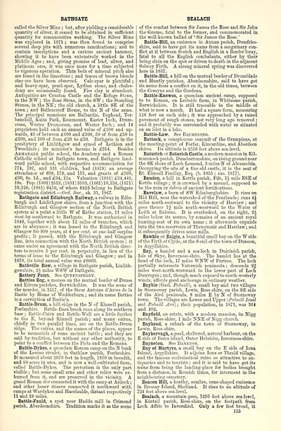
BATHGATE
called the Silver Mine ; but, after yielding a considerable
quantity of silver, it ceased to be obtained in sufficient
quantity for remunerative working.' The Silver Mine
was explored in 1871 ; was then found to comprise
several deep pits with numerous ramifications; and to
contain inscriptions and a curious ancient hammer,
showing it to have been extensively worked in the
Middle Ages ; and, giving promise of lead, silver, and
platinum ores, it was once more for a time subjected
to vigorous operation. Thin beds of mineral pitch also
are found in the limestone ; and traces of brown blende
zinc ore have been observed. Calc-spar is plentiful ;
and heavy-spar, pearl-spar, Lydian stone, and chalce-
dony are occasionally found. Fire clay is abundant.
Antiquities are Couston Castle and the Refuge Stone,
in the WW ; the Boar Stone, in the SW ; the Standing
Stones, in the NE ; the old church, a little SE of the
town ; and Ballencrieff House, to the N of the same.
The principal mansions are Balbardie, Boghead, Tor-
banehill, Kaim Park, Rosemount, Easter Inch, Drum-
cross, "Wester Drum cross, and Wester Inch ; and 14
proprietors hold each an annual value of £500 and up-
wards, 43 of between £100 and £500, 59 of from £50 to
£100, and 100 of from £20 to £50. Bathgate is in the
presbytery of Linlithgow and synod of Lothian and
Tweeddale ; its minister's income is £314. Besides
Armadale public school, the Academy and a Roman
Catholic school at Bathgate town, and Bathgate land-
ward public school, with respective accommodation for
774, 187, and 131 children, had (1879) an average
attendance of 608, 179, and 155, and grants of £599,
£90, 8s. Id., and £94, lis. Valuation (1881) £34,449,
19s. Pop. (1801) 2513, (1831) 3593, (1861) 10,134, (1S71)
10,129, (1881) 9450, of whom 6425 belong to Bathgate
registration district. — Ord. Sur., sh. 31, 1867.
Bathgate and Edinburgh Railway, a railway in Edin-
burgh and Linlithgow shires, from a junction with the
Edinburgh and Glasgow section of the North British
system at a point a little W of Ratho station, 11 miles
west-by-southward to Bathgate. It was authorised in
1846, together with about 12 miles of branches, which
are in abeyance ; it was leased to the Edinburgh and
Glasgow for 999 years, at 4 per cent, at one-half surplus
profits ; it passed, with the Edinburgh and Glasgow
line, into connection with the North British system ; it
came under an agreement with the North British direc-
tors to receive 5 per cent, in perpetuity, in lieu of the
terms of lease to the Edinburgh and Glasgow ; and in
1870, its total annual value was £6660.
Bathville Row, a village in Bathgate parish, Linlith-
gowshire, 2-i miles WSW of Bathgate.
Battery Point. See Queensferry.
Battles Bog, a morass on the mutual border of Dunse
and Edrom parishes, Berwickshire. It was the scene of
the murder, in 1517, of the Sieur Antoine d'Arces de la
Bastie by Home of Wedderburn ; and its name Batties
is a corruption of Bastie's.
Battle-Drum, a hill-ridge in the N of Kinnell parish,
Forfarshire. Battle-Burn brook runs along its southern
base ; Battle-Cairn and Battle-Well are a little further
to the E, beyond Einnell parish ; and many cairns,
chiefly in two parallel lines, are on the Battle-Drum
ridge. The cairns, and the names of the places, appear
to be memorials of some ancient battle ; and they are
said by tradition, but without any other authority, to
point to a conflict between the Picts and the Romans.
Battle-Dykes, a quondam Roman camp on the N bank
of the Lemno rivulet, in Oathlaw parish, Forfarshire.
It measured about 2970 feet in length, 1850 in breadth,
and 80 acres in area, and is now a well-cultivated farm,
called Battle-Dykes. The pretorium is the only part
visible ; but some small urns and other relics were ex-
humed from it, and are preserved in the vicinity. A
grand Roman iter connected it with the camp at Ardoch ;
and other lesser itinera connected it northward with
camps at Wardykes and Haerfaulds, distant respectively
11 and 19 miles.
Battle-Fauld, a spot near Haddo mill in Crimond
parish, Aberdeenshire. Tradition marks it as the scene
BEALACH
of the combat between Sir James the Rose and Sir John
the Grseme, fatal to the former, and commemorated in
the well-known ballad of ' Sir James the Rose.'
Battle-Hill, an eminence in Annan parish, Dumfries-
shire, said to have got its name from a sanguinary con-
flict at it between Scotch and English in a Border foray,
fatal to all the English combatants, either by their
being slain on the spot or driven to death in the adjacent
Solway Firth. A strong mineral spring was discovered
here in 1837.
Battle-Hill, a hill on the mutual border of Drumblade
and Huntly parishes, Aberdeenshire, said to have got
its name from a conflict on it, in the old times, between
the Comyns and the Gordons.
Battle-Knowes, a quondam ancient camp, supposed
to be Roman, on Leetside farm, in "Whitsome parish,
Berwickshire. It is still traceable in the middle of
what is now a marsh. It had a square form, measuring
126 feet on each side ; it was approached by a raised
pavement of rough stones, not very long ago removed ;
and it probably was surrounded with water or situated
on an islet in a lake.
Battle-Law. See Balmerino.
Battock, a conspicuous summit of the Grampians, at
the meeting-point of Forfar, Kincardine, and Aberdeen
shires. Its altitude is 2558 feet above sea-level.
Baturich or Boturich Castle, a modern mansion in Eil-
maronock parish, Dumbartonshire, on rising ground near
the SE shore of Loch Lomond, 3 miles N of Alexandria.
Occupying the site of a fine old castle, it is the seat of
Rt. Elmsall Findlay, Esq. (b. 1855 ; sue. 1877).
Bauden, a hill in Kettle parish, Fife, 1§ mile ESE of
Kettle village ; it is crowned by a mound, supposed to
be the ruin or dibris of ancient fortifications.
Bavelaw, a burn of SW Edinburghshire. It rises on
Mid Hill, near the watershed of the Pentlands ; runs 4J
miles north-eastward to the vicinity of Harelaw ; and
goes thence If mile north-westward to the Water of
Leith at Balcrno. It is overlooked, on the right, 2J
miles below its source, by remains of an ancient royal
hunting-seat of its own name ; it afterwards expands
into the two reservoirs of Thriepmuir and Harelaw ; and
it subsequently drives some mills.
Bawkie or Balgie, a beautiful small bay on the W side
of the Firth of Clyde, at the S end of the town of Dunoon,
in Argyllshire.
Bay, a hamlet and a sea-loch in Duirinish parish,
Isle of Skye, Inverness-shire. The hamlet lies at the
head of the loch, 17 miles WNW of Portree. The loch
partially intersects Vaternish peninsula ; descends 2J
miles west-north-westward to the lower part of Loch
Dimvegan ; and, though much exposed to north-westerly
winds, affords good anchorage in ordinary weather.
Bayble (Gael. Pabaill), a small bay and two villages
in Stornoway parish, Lewis, Ross-shire, on the SE side
of the Aird peninsula, 8 miles E by N of Stornoway
town. The villages are Lower and Upper (Pabaill Iosal
and Pabaill Ard) ; their population, in 1871, was 364
and 402.
Bayfield, an estate, with a modern mansion, in Nigg
parish, Ross-shire, 1 mile NNE of Nigg church.
Bayhead, a suburb of the town of Stornoway, in
Lewis, Ross-shire.
Bayhervagh, a good, sheltered, natural harbour, on the
E side of Barra island, Outer Hebrides, Inverness-shire.
Bayneton. See Baneton.
Bay of Martyrs, a small bay on the E side of Iona
Island, Argyllshire. It adjoins Iona or Threld village,
and the famous ecclesiastical ruins so attractive to an-
tiquaries and to tourists ; and it is said to have got its
name from being the landing-place for bodies brought
from a distance, in Romish times, for interment in the
neighbouring cemetery.
Beacon Hill, a heathy, sombre, cone-shaped eminence
in Bressay Island, Shetland. It rises to an altitude of
724 feet above sea-level.
Bealach, a mountain-pass, 1250 feet above sea-level,
in Kintail parish, Ross-shire, on the footpath from
Loch Affric to Invershiel. Only a few feet broad, it
135
Set display mode to: Large image | Transcription
Images and transcriptions on this page, including medium image downloads, may be used under the Creative Commons Attribution 4.0 International Licence unless otherwise stated. ![]()
| Gazetteers of Scotland, 1803-1901 > Ordnance gazetteer of Scotland > Volume 1 > (171) Page 135 |
|---|
| Permanent URL | https://digital.nls.uk/97370818 |
|---|
| Attribution and copyright: |
|
|---|---|

