Ordnance gazetteer of Scotland > Volume 1
(48) Page 20
Download files
Complete book:
Individual page:
Thumbnail gallery: Grid view | List view
ABERDEENSHIRE
AEERDEENSHIRE
Turriff to Banff (1H miles), authorised on 27 July
1857, under the name of the Banff, Macduff, and Turriff
Extension, was opened on 4 June 1860, and was ex-
tended from Banff to Macduff (} mile) in 1872. The
entire system has a total length of 29£ miles, with 10
stations and summit levels of 405 and 374 feet ; was in-
corporated with the Great North of Scotland on 30
July 1866 ; and is brought into a circle with it by the
Banffshire Railway, extending south-westward from
Banff harbour to Grange Junction.
Aberdeen Railway, a railway from Aberdeen, south-
south-westward to the centre of Forfarshire. It was
authorised on 31 July 1845, and opened on 30 March
1850. It cost very much more per mile than had been
estimated, yet a good deal less than either the Scottish
Central, the Edinburgh, Perth, & Dundee, the North
British, or the Caledonian. It commences at Guild
Street, adjacent to the upper dock and to the foot of
Market Street ; crosses the Dee at Polmuir, by the
viaduct noticed on p. 12 ; proceeds by the stations of
Cove, Portlethen, Newtonhill, and Muchalls, to Stone-
haven ; goes thence through the fertile district of the
Mearns, by the stations of Drumlithie, Fordoun, Lau-
rencekirk, Marykirk, and Craigo, to the northern border
of Forfarshire ; sends off at Dubton Junction a branch
3 miles and 160 yards eastward to Montrose ; sends off
again at Bridge-of-Dun Junction a branch of 3 miles and
862 yards westward to Brechin ; proceeds by the station
of Farnell Road to Guthrie Junction, and makes also a
junction with the Arbroath and Forfar railway at Friock-
heim. That railway, previously formed, was leased to it in
1848, and ultimately incorporated with it. The Aberdeen
itself and the Scottish Midland Junction were amalga-
mated in 1856, under the name of the Scottish North-
Eastern ; and the Scottish North-Eastern, in turn, was
amalgamated with the Caledonian, in 1866 ; so that the
Aberdeen is now the northern part of the Caledonian
system. The length of the Aberdeen proper, exclusive
of branches, is 49 miles, and inclusive of branches and
of the Arbroath and Forfar, is 72 miles.
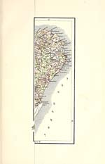
Aberdeenshire, a maritime county, forming the ex-
treme NE of Scotland, lies between 56° 52' and 57° 42'
N lat, and between 1° 48' and 3° 46' W long. It is
bounded N and E by the German Ocean, S by the
counties of Kincardine, Forfar, and Perth, and W by
those of Inverness and Banff. Its outline is very irre-
gular ; but roughly describes an oblong extending from
NE to SW, broadest near the middle and narrowing
towards the SW. The greatest length, from Cairnbulg
Head, on the E side of Fraserburgh Bay, to Cairn
Ealer, at the meeting-point with Perth and Inverness
shires, is 85-J miles ; the'greatest breadth, from the mouth
of the river Dee to the head-springs of the river Don, is
47 miles ; and the circuit line measures some 2S0 miles,
62 of which are sea-coast. Fifth in size of the Scottish
counties, Aberdeenshire has an area of 1970 square miles
or 1,260,625 acres. It was anciently divided into
Buchan in the N, Formartine, Strathbogie, and Garioeh
in the middle, and Mar in the SW ; it is now divided
into the districts of Deer, Turriff, Huntly, Garioeh,
Alford, Ellon, Aberdeen, and Kincardine O'Neil.
The surface, in a general view, consists largely of tame
levels or uninteresting tumulations, but includes the
long splendid valleys of the Don and Dee, and ascends
to the grand Grampian knot of the Cairngorm Moun-
tains. The coast is mostly bold and rugged, occasion-
ally rising into precipices, 100 to 150 feet high, and
pierced with extensive caverns, but in the southern
part, adjacent to Aberdeen, sinks into broad sandy flats.
About two-thirds of the entire surface are either moss,
moor, hill, or mountain. Much of the scenery is bleak
and cheerless, but around some of the larger towns, and
along the courses of the principal rivers, it abounds
with features of beauty or grandeur. In the SW the
Cairngorm and the Grampian Mountains combine, with
corries, glens, and valleys among or near them, to form
magnificent landscapes ; throughout the shire, from N
to S, and crosswise from W to E, the following are the
chief summits, those marked with asterisks culminating
20
on the boundary: — Hill of Fishrie (749 feet), Mormond
Hill (769), Hill of Shenwall (957), *Meikle Balloch
(1199), Clashmaeh Hill (1229), Corsegight (619), Dud-
wick (572), Top of Noth (1851), Hill of Foudland (1509),
Core Hill (804), Buck of Cabrach (2368), *Carn Mor
(2636), Correen Hills (1699), Caillievar (1747), Ben-
nachie (1698), Hill of Fare (1545), Brimmond Hill
(870), Brown Cow Hill (2721), Morven Hill (2862),
*Ben Avon (3843), *Braeriach (4248), Cairntoul (4241),
Ben Macdhui (4296), Beinn Bhrotain (3795), *An Sgar-
soch (3300), *Beinn a' Chaoruinn (3553), *Beinn a'
Bhuird (3924), Cam Eas (3556), *Beinn Iutharn Mhor
(3424), *Cairn na Glasha (3484), Lochnagar (3786),
Mount Keen (3077), and Cock Cairn (2387). The princi-
pal rivers are the Deveron, rising in the north-west and
soon passing into Banffshire ; the Bogie, running to the
Deveron, about J mile below Huntly ; the Ugie, run-
ning south-eastward to the sea, about a mile N of
Peterhead ; the Cruden, running eastward to the sea at
Cruden Bay ; the Ythan, running 33-J miles north-east-
ward and south-eastward to the sea, a little below New-
burgh ; the TJrie, going south-eastward to the Don, at
Inverurie; the Don, rising at an altitude of 1980 feet,
adjacent to the county's western boundary, and making
a sinuous run eastward of about 82J miles, all within the
county, to the sea in the vicinity of Old Aberdeen ; and
the Dee, rising on Cairntoul, at 4060 feet above sea-
level, and making a sinuous run of about 87 miles,
partly through Braemar, partly through the Aberdeen
portions of Deeside, and partly along the boundary with
Kincardineshire to the sea at Aberdeen. The chief
lakes are Lochs Dhu, Muick, Callater, Brothacan, Kin-
Ord, Drum, and Strathbeg, but are all small. Granite is
the prevailing rock ; occurs of various kinds or qualities ;
forms the great mass of the mountains together with ex-
tensive tracts eastward to the sea ; has, for about 300
years, been extensively worked ; and in recent times, up
to 1881, has been in rapidly increasing demand as an
article of export. The quantities shipped at Aberdeen
alone are remarkably great. The quarries of it at Kemnay
employ about 250 workmen, with the aid of steam power,
all the year round, and since 1858, have raised Kemnay
from the status of a rural hamlet to that of a small town.
Other notable quarries are those of Rubislaw, Sclattie,
Dancing Cairn, Persley, Cairngall, and Stirling-Hill,
near Peterhead. The Kemnay granite has a light colour
and a close texture, and owes to these properties its high
acceptance in the market. The Rubislaw granite is of a
fine dark-blue colour, and was the material used in the
construction of great part of Union Street in Aberdeen.
The Cairngall granite is small grained, of fine texture,
and admirably suited for polishing and for ornamental
work ; it furnished the sarcophagus for the remains of
the late Prince Consort. The Stirling-Hill or Peterhead
granite is of a red colour, and of much larger grain than
the other granites ; it is much used for mural tablets,
monumental stones, and ornate pillar shafts. The
granites are sometimes associated with gneiss, with
Silurian rocks, or with greenstone, basalt, or other
traps ; and, viewed in connection with these, they form
fully eight-ninths of the substrata of the entire county.
Devonian rocks occur in the north, underlie the wide
level moors and mosses of Buchan, and have yielded
millstones in the parish of Aberdour. Blue slate, two
beds of limestone, and a large vein of ironstone occur
in Culsalmond parish, forming parts of strata which
have been much tilted and deranged ; and both the
slate and the limestone have been worked. Limestone
abounds also in other localities ; but, owing to the
scarcity of coal, except near a seaport, it cannot be
advantageously worked. Beautiful green serpentine,
with white and grey spots, occurs in Leslie parish, and
is easily wrought into snuff-boxes and ornamental
objects. Plumbago and indications of metallic ores
have been found in Huntly parish. Gold, in small
quantities, has been found in Braemar, and on parts of
the coast near Aberdeen. Amethysts, beryls, emeralds,
and other precious stones, particularly the species of
rock crystal called cairngorms, are found in the moun-
AEERDEENSHIRE
Turriff to Banff (1H miles), authorised on 27 July
1857, under the name of the Banff, Macduff, and Turriff
Extension, was opened on 4 June 1860, and was ex-
tended from Banff to Macduff (} mile) in 1872. The
entire system has a total length of 29£ miles, with 10
stations and summit levels of 405 and 374 feet ; was in-
corporated with the Great North of Scotland on 30
July 1866 ; and is brought into a circle with it by the
Banffshire Railway, extending south-westward from
Banff harbour to Grange Junction.
Aberdeen Railway, a railway from Aberdeen, south-
south-westward to the centre of Forfarshire. It was
authorised on 31 July 1845, and opened on 30 March
1850. It cost very much more per mile than had been
estimated, yet a good deal less than either the Scottish
Central, the Edinburgh, Perth, & Dundee, the North
British, or the Caledonian. It commences at Guild
Street, adjacent to the upper dock and to the foot of
Market Street ; crosses the Dee at Polmuir, by the
viaduct noticed on p. 12 ; proceeds by the stations of
Cove, Portlethen, Newtonhill, and Muchalls, to Stone-
haven ; goes thence through the fertile district of the
Mearns, by the stations of Drumlithie, Fordoun, Lau-
rencekirk, Marykirk, and Craigo, to the northern border
of Forfarshire ; sends off at Dubton Junction a branch
3 miles and 160 yards eastward to Montrose ; sends off
again at Bridge-of-Dun Junction a branch of 3 miles and
862 yards westward to Brechin ; proceeds by the station
of Farnell Road to Guthrie Junction, and makes also a
junction with the Arbroath and Forfar railway at Friock-
heim. That railway, previously formed, was leased to it in
1848, and ultimately incorporated with it. The Aberdeen
itself and the Scottish Midland Junction were amalga-
mated in 1856, under the name of the Scottish North-
Eastern ; and the Scottish North-Eastern, in turn, was
amalgamated with the Caledonian, in 1866 ; so that the
Aberdeen is now the northern part of the Caledonian
system. The length of the Aberdeen proper, exclusive
of branches, is 49 miles, and inclusive of branches and
of the Arbroath and Forfar, is 72 miles.
Aberdeenshire, a maritime county, forming the ex-
treme NE of Scotland, lies between 56° 52' and 57° 42'
N lat, and between 1° 48' and 3° 46' W long. It is
bounded N and E by the German Ocean, S by the
counties of Kincardine, Forfar, and Perth, and W by
those of Inverness and Banff. Its outline is very irre-
gular ; but roughly describes an oblong extending from
NE to SW, broadest near the middle and narrowing
towards the SW. The greatest length, from Cairnbulg
Head, on the E side of Fraserburgh Bay, to Cairn
Ealer, at the meeting-point with Perth and Inverness
shires, is 85-J miles ; the'greatest breadth, from the mouth
of the river Dee to the head-springs of the river Don, is
47 miles ; and the circuit line measures some 2S0 miles,
62 of which are sea-coast. Fifth in size of the Scottish
counties, Aberdeenshire has an area of 1970 square miles
or 1,260,625 acres. It was anciently divided into
Buchan in the N, Formartine, Strathbogie, and Garioeh
in the middle, and Mar in the SW ; it is now divided
into the districts of Deer, Turriff, Huntly, Garioeh,
Alford, Ellon, Aberdeen, and Kincardine O'Neil.
The surface, in a general view, consists largely of tame
levels or uninteresting tumulations, but includes the
long splendid valleys of the Don and Dee, and ascends
to the grand Grampian knot of the Cairngorm Moun-
tains. The coast is mostly bold and rugged, occasion-
ally rising into precipices, 100 to 150 feet high, and
pierced with extensive caverns, but in the southern
part, adjacent to Aberdeen, sinks into broad sandy flats.
About two-thirds of the entire surface are either moss,
moor, hill, or mountain. Much of the scenery is bleak
and cheerless, but around some of the larger towns, and
along the courses of the principal rivers, it abounds
with features of beauty or grandeur. In the SW the
Cairngorm and the Grampian Mountains combine, with
corries, glens, and valleys among or near them, to form
magnificent landscapes ; throughout the shire, from N
to S, and crosswise from W to E, the following are the
chief summits, those marked with asterisks culminating
20
on the boundary: — Hill of Fishrie (749 feet), Mormond
Hill (769), Hill of Shenwall (957), *Meikle Balloch
(1199), Clashmaeh Hill (1229), Corsegight (619), Dud-
wick (572), Top of Noth (1851), Hill of Foudland (1509),
Core Hill (804), Buck of Cabrach (2368), *Carn Mor
(2636), Correen Hills (1699), Caillievar (1747), Ben-
nachie (1698), Hill of Fare (1545), Brimmond Hill
(870), Brown Cow Hill (2721), Morven Hill (2862),
*Ben Avon (3843), *Braeriach (4248), Cairntoul (4241),
Ben Macdhui (4296), Beinn Bhrotain (3795), *An Sgar-
soch (3300), *Beinn a' Chaoruinn (3553), *Beinn a'
Bhuird (3924), Cam Eas (3556), *Beinn Iutharn Mhor
(3424), *Cairn na Glasha (3484), Lochnagar (3786),
Mount Keen (3077), and Cock Cairn (2387). The princi-
pal rivers are the Deveron, rising in the north-west and
soon passing into Banffshire ; the Bogie, running to the
Deveron, about J mile below Huntly ; the Ugie, run-
ning south-eastward to the sea, about a mile N of
Peterhead ; the Cruden, running eastward to the sea at
Cruden Bay ; the Ythan, running 33-J miles north-east-
ward and south-eastward to the sea, a little below New-
burgh ; the TJrie, going south-eastward to the Don, at
Inverurie; the Don, rising at an altitude of 1980 feet,
adjacent to the county's western boundary, and making
a sinuous run eastward of about 82J miles, all within the
county, to the sea in the vicinity of Old Aberdeen ; and
the Dee, rising on Cairntoul, at 4060 feet above sea-
level, and making a sinuous run of about 87 miles,
partly through Braemar, partly through the Aberdeen
portions of Deeside, and partly along the boundary with
Kincardineshire to the sea at Aberdeen. The chief
lakes are Lochs Dhu, Muick, Callater, Brothacan, Kin-
Ord, Drum, and Strathbeg, but are all small. Granite is
the prevailing rock ; occurs of various kinds or qualities ;
forms the great mass of the mountains together with ex-
tensive tracts eastward to the sea ; has, for about 300
years, been extensively worked ; and in recent times, up
to 1881, has been in rapidly increasing demand as an
article of export. The quantities shipped at Aberdeen
alone are remarkably great. The quarries of it at Kemnay
employ about 250 workmen, with the aid of steam power,
all the year round, and since 1858, have raised Kemnay
from the status of a rural hamlet to that of a small town.
Other notable quarries are those of Rubislaw, Sclattie,
Dancing Cairn, Persley, Cairngall, and Stirling-Hill,
near Peterhead. The Kemnay granite has a light colour
and a close texture, and owes to these properties its high
acceptance in the market. The Rubislaw granite is of a
fine dark-blue colour, and was the material used in the
construction of great part of Union Street in Aberdeen.
The Cairngall granite is small grained, of fine texture,
and admirably suited for polishing and for ornamental
work ; it furnished the sarcophagus for the remains of
the late Prince Consort. The Stirling-Hill or Peterhead
granite is of a red colour, and of much larger grain than
the other granites ; it is much used for mural tablets,
monumental stones, and ornate pillar shafts. The
granites are sometimes associated with gneiss, with
Silurian rocks, or with greenstone, basalt, or other
traps ; and, viewed in connection with these, they form
fully eight-ninths of the substrata of the entire county.
Devonian rocks occur in the north, underlie the wide
level moors and mosses of Buchan, and have yielded
millstones in the parish of Aberdour. Blue slate, two
beds of limestone, and a large vein of ironstone occur
in Culsalmond parish, forming parts of strata which
have been much tilted and deranged ; and both the
slate and the limestone have been worked. Limestone
abounds also in other localities ; but, owing to the
scarcity of coal, except near a seaport, it cannot be
advantageously worked. Beautiful green serpentine,
with white and grey spots, occurs in Leslie parish, and
is easily wrought into snuff-boxes and ornamental
objects. Plumbago and indications of metallic ores
have been found in Huntly parish. Gold, in small
quantities, has been found in Braemar, and on parts of
the coast near Aberdeen. Amethysts, beryls, emeralds,
and other precious stones, particularly the species of
rock crystal called cairngorms, are found in the moun-
Set display mode to: Large image | Transcription
Images and transcriptions on this page, including medium image downloads, may be used under the Creative Commons Attribution 4.0 International Licence unless otherwise stated. ![]()
| Gazetteers of Scotland, 1803-1901 > Ordnance gazetteer of Scotland > Volume 1 > (48) Page 20 |
|---|
| Permanent URL | https://digital.nls.uk/97369342 |
|---|
| Attribution and copyright: |
|
|---|---|
| Description | A survey of Scottish topography, statistical, biographical, and historical. Edited by Francis H. Groome. Edinburgh: Thomas C. Jack, 1884-85. "General survey": v.6, 134 p. at end. |
|---|---|
| Shelfmark | Map.Ref.C18 |
| Additional NLS resources: | |
| Description | 20 volumes of the most popular descriptive gazetteers of Scotland, providing a comprehensive geographical encyclopaedia of Scotland in the 19th century. Principal places in Scotland, including towns, counties, castles, glens, antiquities and parishes, are listed alphabetically. Each entry includes detailed historical and geographical information about each place. |
|---|---|