Topographical dictionary of Scotland > Volume 2
(195) Page 187
Download files
Complete book:
Individual page:
Thumbnail gallery: Grid view | List view

LINT
LINT
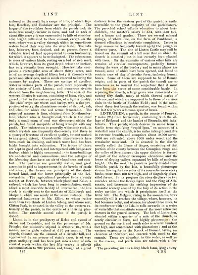
inclosed on the north by a range of hills, of which Kip-
law, Hoselaw, and Blakelaw are the principal. The
larger of the two lakes from which the parish took its
name was nearly circular in form, and had an area of
about fifty acres ; it was surrounded by hills of consider-
able height cultivated to their summit, except on the
west, where was a valley through which its superfluous
waters found their way into the river Kale. The lake
has, however, been drained, and at present forms a
valuable tract of land appropriated to corn husbandry,
for which it appears to be well adapted. The substratum
is moss of various kinds, resting on a bed of rich marl,
which, however, from its great depth below the surface,
has only recently been wrought. Hoselaw lake com-
prises a rectangular area of about thirty acres, and
is of an average depth of fifteen feet ; it abounds with
perch and silver-eels, and is much resorted to during the
summer by anglers. There are springs of excellent
water in various parts of the parish, more especially in
the vicinity of Loch Linton ; and numerous rivulets
descend from the neighbouring hills. The soil of the
western district is various, consisting of loam, clay, and
gravel ; that in the eastern portion, of a lighter quality.
The chief crops are wheat and barley, with a due pro-
portion of oats ; the plantations consist of fir, oak, ash,
and elm, for which the soil seems favourable. The
principal manure is lime, obtained from Northumber-
land, whence also is brought coal, which is the chief
fuel ; a small seam of coal was discovered within the
parish, but found incapable of being wrought with any
profit. The substratum is generally whinstone rock, in
which crystals are frequently discovered ; and there is
a quarry of freestone of excellent quality, but not worked
to any great extent, Considerable improvements have
been made in draining, and much waste land has been
lately brought into cultivation. The fences of thorn
are kept in good order, and interspersed with hedge-row
timber, which is highly ornamental ; the farm-buildings
are substantial and commodious, and the cottages of
the labouring class have an air of cleanliness and com-
fort. The pastures are generally fertile, and great
attention is paid to improvement in the breeds of cattle
and sheep ; the former are principally of the short-
horned kind, and the latter principally of the Lei-
cestershire. The agricultural produce finds a ready
market at Berwick, between which place and Kelso, a
railroad, which has been long in contemplation, would
afford a most desirable facility of intercourse ; the live
stock is chiefly sent to the markets of Edinburgh and
Morpeth, which are nearly at the same distance. The
principal landowner is Mr. Elliot, to whom rather
more than two-thirds of Linton belong, and whose seat,
Clifton Park, is situated in the valley at the western ex-
tremity of the parish, in the centre of a thriving plan-
tation. The rateable annual value of the parish is
£5586.
Linton is in the presbytery of Kelso and synod of
Merse and Teviotdale, and in the patronage of Mr.
Pringle; the minister's stipend is £239. 2. 10., with a
manse, and a glebe valued at £12 per annum. The
church, situated on the summit of a circular hill, and
approached by an avenue of stately trees, is of very
great antiquity, and has been put into a state of sub-
stantial repair within the last fifty years ; it affords
accommodation to 200 persons, and, though at a great
187
distance from the eastern part of the parish, is easily
accessible to the great majority of the parishioners.
The parochial school affords education to about forty
children ; the master's salary is £34, with £30 fees,
and a house and garden. There are several mineral
springs, of which one, on the farm of Bankhead, is
deemed efficacious in scorbutic complaints. Jasper in
large masses is frequently turned up by the plough in
different parts. The site of Linton Castle may still be
traced on the summit of a hill near that on which the
church is situated ; but it has recently been planted
with trees. On the summits of various other hills are
remains of circular encampments, probably formed
during the wars of the border ; and in many places are
tumuli, some of which have been opened, and found to
contain urns of clay of circular form, inclosing human
bones. Some of them are supposed to be of Roman
origin ; and in parts of the parish the tumuli are so
numerous as to warrant the conjecture that it must
have been the scene of some considerable battle. In
repairing the church, a large grave was discovered con-
taining fifty skulls, many of which showed marks of
violence, and which are supposed to be those of warriors
slain in the battle of Flodden Field ; and in the moss,
about three feet beneath the surface, was found within
the last few years a Roman spear of brass.
LINTRATHEN, a parish, in the county of Forfar,
7 miles (W.) from Kirriemuir; containing, with the vil-
lage of Bridgend and the hamlet of Pitmudie, 981 inha-
bitants. This parish, which derives its name from a
Gaelic term signifying "rapid lynn," on account of a
waterfall near the church, is ten miles in length, and five
in extreme breadth, and comprises about 10,000 acres;
3000 are cultivated, above 1000 under wood, and the
remainder moorland. It is situated in the district
usually called the Braes of Angus, consisting of that
portion of the county between the Grampian range and
the valley of Strathmore ; the upper division is formed
of part of the inferior Grampian elevations, and the
lower of sloping valleys, separated by hills of moderate
height. On the west, the parish is partly divided from
Glenisla parish by the Isla, a beautifully-picturesque
stream flowing for two miles of its course between rocky
banks, more than 100 feet high, and of singularly-diver-
sified forms. In its progress the river displays the two
cascades named the Reeky Lynn and the Slug of Ach-
rannie, and increases the striking impression of the
romantic scenery around by the fury of its action in the
rocky cavities into which it precipitates itself at the
latter fall. The Melgum, rising in the mountains, flows
smoothly till it reaches the village, where, however, its
bed becomes rocky, and whence, for about three miles, to
its confluence with the Isla, it rolls onwards in a series
of waterfalls that constitute some of the most attractive
features in the general scenery. The loch of Lintrathen,
situated within a quarter of a mile of the church, is
nearly circular in form, and highly picturesque : the
ground on the north and south sides is several hundred
feet high, and ornamented with plantations ; and at the
western extremity is the Knock of Formal, having an
elevation of 1500 feet, and covered with wood to the
summit. Trout are abundant in this water, as well as
in the rivers ; and perch also are taken, with a few
pike.
The prevailing soil is a deep black loam, lying chiefly
2 B 2
Set display mode to: Large image | Transcription
Images and transcriptions on this page, including medium image downloads, may be used under the Creative Commons Attribution 4.0 International Licence unless otherwise stated. ![]()
| Gazetteers of Scotland, 1803-1901 > Topographical dictionary of Scotland > Volume 2 > (195) Page 187 |
|---|
| Permanent URL | https://digital.nls.uk/97363469 |
|---|
| Description | Volume II: From Keanlochbervie to Zetland. |
|---|---|
| Attribution and copyright: |
|

