Gazetteer of Scotland
(415) Page 405
Download files
Complete book:
Individual page:
Thumbnail gallery: Grid view | List view

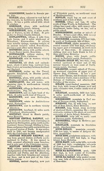
SCO
405
SCU
SCOONIEBURN, hamlet in Scoonie par-
ish, Fife.
SCORAIG, place, adjacent to vast bed of
bog iron-ore, in Lochbroom parish, Ross-
shire. It has a public school with about
78 scholars.
SCORIDALE, place, with medicinal
spring, in Orphir parish, Orkney.
SCORRIEBRECK, farm, 4 miles north-
east of Portree, in Isle of Skye. It gave
shelter to Prince Charles Edward.
SCOTLANDWELL, village, f mile from
Loch Leven, and 5 miles south-east of
Milnathort, Kinross-shire. It adjoins
some notable springs, contains vestiges of
an ancient hospital called Fons-Scotire,
and has a post office under Kinross.
SCOTSBURN, place, with public school,
in Losie-Easter parish, Ross-shire.
SCOTSCALDER, railway station, 18£
miles west of "Wick, Caithness.
SCOTSCRAIG, seat in western vicinity
of Tayport, Fife.
SCOTSDYKE, old ditch and embank-
ment, about 4 miles long, eastward from
Sark rivulet, on boundary between Scotland
and England.
SCOTSHOLE, ravine on the Tweed,
opposite Ringlyhall, in Maxton parish,
Roxburghshire.
SCOTSMILL, place, with public school,
in Tullynessle parish, Aberdeenshire.
SCOTSTARVIT, fine old tower, with
charming view, in south-eastern vicinity
of Cupar, Fife.
SCOTSTOWN, village in Renfrew parish,
Renfrewshire. Pop. 757.
SCOTSTOWN, seat on right bank of the
Clyde, 4^ miles north-west of Glasgow.
SCOTSTOWN, seat near Rutherglen,
Lanarkshire.
SCOTSTOWN, estate in Auchterhouse
parish, Forfarshire.
SCOTSTOWN, seat in northern vicinity
of Aberdeen.
SCOTSTOWN, headland, 3| miles north
of Peterhead, Aberdeenshire.
SCOTSWAY, island in Harris parish,
Outer Hebrides.
SCOTTISH CENTRAL RAILWAY, rail-
way from two junction lines converging at
Larbert in Stirlingshire, going north-north-
westward thence through Stirling to Dun-
blane,and proceeding north-eastward thence
to general station of Perth. It was autho-
rized in 1845, and became amalgamated
with the Caledonian in 1865.
SCOTTISH MIDLAND RAILWAY, rail-
way from general station at Perth north-
eastward to Forfar. It was opened in
1848, acquired afterwards some branches,
and is now part of the Caledonian system.
SCOTTISH NORTH-EASTERN RAIL-
WAY, railway system formed in 1856 by
amalgamation of the Scottish Midland, the
Arbroath and Forfar, and the Aberdeen,
together with their branches and connect-
ing lines, and is now part of the Cale-
donian system.
SCOUGAL, ancient chapelry, now part
of "Whitekirk parish, on north-east coast
of Haddingtonshire.
SCOULAG, small bay on east coast of
southern part of Isle of Bute.
SCOURIE, village and bay, 21 miles
south of Cape Wrath, in Sutherland. The
village has a post office, with money order
department, under Lairg, an inn, and a
public school.
SCOURINGBURN, section or suburb of
Dundee. It has a post office, with money
order department, under Dundee.
SCOURMORE, mountain, 1774 feet high,
in north of Trotternish, Isle of Skye.
SCOUR-OURAN, alpine mountain, with
conical summit 3505 feet high, overhang-
ing upper part of C41enshiel, on south-west
border of Ross-shire. It commands a
striking view over Loch Duich to Isle of
Skye and Outer Hebrides.
SCOYNE, place, with female public
school, in Panbride parish, Forfarshire.
SCRAADA (HOLES OF), two wide, deep,
vertical apertures at inner end of two
natural tunnels on west coast of Xorth-
maven parish, Shetland.
SCRABSTER, seaport suburb of Thurso,
on westward expansion of upper part of
Thurso Bay, Caithness. It has a post
office under Thurso, and it adjoins vestiges
of Scrabster Castle, once a residence of the
Bishops of Caithness, and afterwards a
fortalice of the crown.
SCRAPE, round-backed mountain, 2347
feet high, with traces of Roman road and
with extensive view, 8 miles south-west of
Peebles.
SCRAULAC, mountain, 2432 feet high,
6 miles north-north-west of Ballater,
Aberdeenshire.
SCREBHISBEN, mountain in Parf sec-
tion of Durness parish, Sutherland.
SCRESORT, bay, 1| mile long, on east
side of Rum Island, Inner Hebrides.
SCRIDEN, long, broad, steep declivity
of shattered blocks, appearing like a rocky
avalanche rushing to the shore, at northern
extremity of Arran Island, Buteshire.
SCRISHBEN, lofty hill on north coast
of Durness parish, Sutherland.
SCROGIEHILL, village in Methven par-
ish, Perthshire.
SCROULACH, mountain in Strathdon
parish, Aberdeenshire.
SCUIR-DONALD, mountain - summit,
2730 feet high, in centre of Ardgour dis-
trict, Argyleshire.
SCUIR-EIGG, precipitous eminence, with
columnar peak 1272 feet high, in Eigg
Island, Inner Hebrides.
SCUIR-MAXY, bold rocky hills, upwards
of 1600 feet high, overhanging cataracts
of Conan river immediately below Loch
Luichart, Ross-shire.
SCUIR-NA-BANACHTICH, peak, 3200
feet high, in west centre of Cuchullin
Mountains, in south of Isle of Skye.
SCUIR-RA-CAIRAN, lofty peaked moun-
tain near falls of Glomach, in south-west
of Ross-shire.
Set display mode to: Large image | Transcription
Images and transcriptions on this page, including medium image downloads, may be used under the Creative Commons Attribution 4.0 International Licence unless otherwise stated. ![]()
| Gazetteers of Scotland, 1803-1901 > Gazetteer of Scotland > (415) Page 405 |
|---|
| Permanent URL | https://digital.nls.uk/97360201 |
|---|

