Gazetteer of Scotland
(38) Page 28
Download files
Complete book:
Individual page:
Thumbnail gallery: Grid view | List view

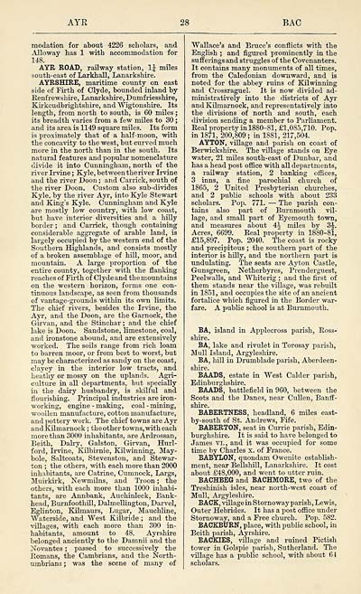
AYR
28
BAC
modation for about 4226 scholars, and
Alloway has 1 with accommodation for
148.
AYR ROAD, railway station, 1£ miles
south-east of Larkhall, Lanarkshire.
AYRSHIRE, maritime county on east
side of Firth of Clyde, bounded inland by
Renfrewshire, Lanarkshire, Dumfriesshire,
Kirkcudbrightshire, and Wigtonshire. Its
length, from north to south, is 60 miles ;
its breadth varies from a few miles to 30 ;
and its area is 1149 square miles. Its form
is proximately that of a half-moon, with
the concavity to the west, but curved much
more in the north than in the south. Its
natural features and popular nomenclature
divide it into Cunningham, north of the
river Irvine ; Kyle, betweentheriver Irvine
and the river Doon ; and Carrick, south of
the river Doon. Custom also sub-divides
Kyle, by the river Ayr, into Kyle Stewart
and King's Kyle. Cunningham and Kyle
are mostly low country, with low coast,
but have interior diversities and a hilly
border ; and Carrick, though containing
considerable aggregate of arable land, is
largely occupied by the western end of the
Southern Highlands, and consists mostly
of a broken assemblage of hill, moor, and
mountain. A large proportion of the
■entire county, together with the flanking
reaches of Firth of Clyde and th e mountains
on the western horizon, forms one con-
tinuous landscape, as seen from thousands
of vantage-grounds within its own limits.
The chief rivers, besides the Irvine, the
Ayr, and the Doon, are the Garnock, the
Girvan, and the Stinchar; and the chief
lake is Doon. Sandstone, limestone, coal,
and ironstone abound, and are extensively
worked. The soils range from rich loam
to barren moor, or from best to worst, but
may be characterized as sandy on the coast,
clayey in the interior low tracts, and
heathy or mossy on the uplands. Agri-
culture in all departments, but specially
in the dairy husbandry, is skilful and
flourishing. Principal industries are iron-
working, engine - making, coal - mining,
woollen manufacture, cotton manufacture,
and pottery work. The chief towns are Ayr
and Kilmarnock ; the other towns, with each
more than 3000 inhabitants, are Ardrossan,
Beith, Dairy, Galston, Girvan, Hurl-
ford, Irvine, Kilbirnie, Kilwinning, May-
bole, Saltcoats, Stevenston, and Stewar-
ton ; the others, with each more than 2000
inhabitants, are Catrine, Cumnock, Largs,
Muirkirk, Newmilns, and Troon ; the
others, with each more than 1000 inhabi-
tants, are Annbank, Auchinleck, Bank-
head, Burnfoothill, Dalmellington, Darvel,
Eglinton, Kilmaurs, Lugar, Mauchline,
Waterside, and West Kilbride ; and the
villages, with each more than 300 in-
habitants, amount to 48. Ayrshire
belonged anciently to the Damnii and the
Novantes ; passed to successively the
Romans, the Cambrians, and the North-
umbrians ; was the scene of many of
Wallace's and Bruce's conflicts with the
English ; and figured prominently in the
suff erings and struggles of the Covenanters.
It contains many monuments of all times,
from the Caledonian downward, and is
noted for the abbey ruins of Kilwinning
and Crossraguel. It is now divided ad-
ministratively into the districts of Ayr
and Kilmarnock, and representatively into
the divisions of north and south, each
division sending a member to Parliament.
Real property in 1880-81, £1,085,710. Pop.
in 1871, 200,809 ; in 1881, 217,504.
AYTON, village and parish on coast of
Berwickshire. The village stands on Eye
water, 21 miles south-east of Dunbar, and
has a head post office with all departments,
a railway station, 2 banking offices,
3 inns, a fine parochial church of
1865, 2 United Presbyterian churches,
and 2 public schools with about 233
scholars. Pop. 771. — The parish con-
tains also part of Burnmouth vil-
lage, and small part of Eyemouth town,
and measures about 4^ miles by 3J.
Acres, 6699. Real property in 1880-81,
£15,897. _ Pop. 2040. The coast is rocky
and precipitous ; the southern part of the
interior is hilly, and the northern part is
undulating. The seats are Ayton Castle,
Gunsgreen, Netherbyres, Prenderguest,
Peelwalls, and Whiterig ; and the first of
them stands near the village, was rebuilt
in 1851, and occupies the site of an ancient
fortalice which figured in the Border war-
fare. A public school is at Burnmouth.
BA, island in Applecross parish, Ross-
shire.
BA, lake and rivulet in Torosay parish,
Mull Island, Argyleshire.
BA, hill in Drumblade parish, Aberdeen-
shire.
BAADS, estate in West Calder parish,
Edinburghshire.
BAADS, battlefield in 960, between the
Scots and the Danes, near Cullen, Banff-
shire.
BABERTNESS, headland, 6 miles east-
by-south of St. Andrews, Fife.
BABERTON, seat in Currie parish, Edin-
burghshire. It is said to have belonged to
James VI., and it was occupied for some
time by Charles x. of France.
BABYLON, quondam Owenite establish-
ment, near Bellshill, Lanarkshire. It cost
about £48,000, and went to utter ruin.
BACHBEG and BACHMORE, two of the
Treshinish isles, near north-west coast of
Mull, Argyleshire.
BACK, village inStornoway parish, Lewis,
Outer Hebrides. It has a post office under
Stornoway, and a Free church. Pop. 582.
BACKBURN, place, with public school, in
Beith parish, Ayrshire.
BACKIES, village and ruined Pictish
tower in Golspie parish, Sutherland. The
village has a public school, with about 64
scholars.
Set display mode to: Large image | Transcription
Images and transcriptions on this page, including medium image downloads, may be used under the Creative Commons Attribution 4.0 International Licence unless otherwise stated. ![]()
| Gazetteers of Scotland, 1803-1901 > Gazetteer of Scotland > (38) Page 28 |
|---|
| Permanent URL | https://digital.nls.uk/97355677 |
|---|

