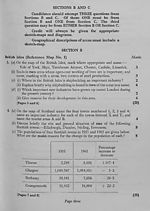
Download files
Complete book:
Individual page:
Thumbnail gallery: Grid view | List view

Marks
5. Give a geographical account of one of the following regions:—•
East Anglia, Central Plain of Ireland, South Wales, Cornwall and Devon. (20)
[Pages 9 and 10]
6. In what ways are the British Isles favourably situated for foreign trade ? (20)
[Pages 11 and 12]
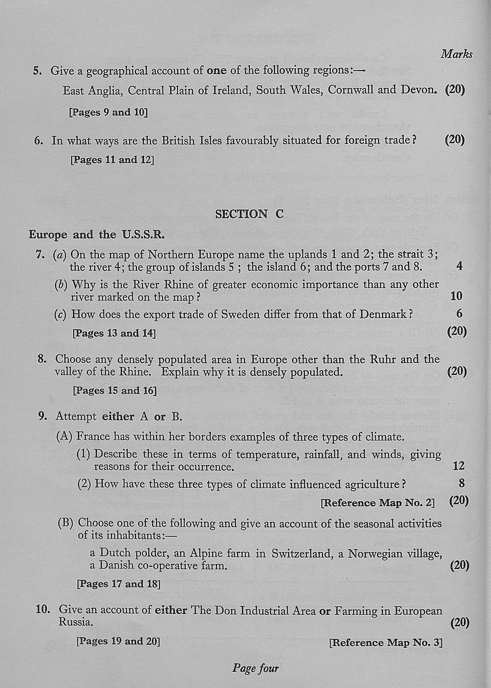
SECTION C
Europe and the U.S.S.R.
7. (a) On the map of Northern Europe name the uplands 1 and 2; the strait 3;
the river 4; the group of islands 5 ; the island 6; and the ports 7 and 8. 4
{b) Why is the River Rhine of greater economic importance than any other
river marked on the map ? 10
(c) How does the export trade of Sweden differ from that of Denmark ? 6
[Pages 13 and 14] (20)
8. Choose any densely populated area in Europe other than the Ruhr and the
valley of the Rhine. Explain why it is densely populated. (20)
[Pages 15 and 16]
9. Attempt either A or B.
(A) France has within her borders examples of three types of climate.
(1) Describe these in terms of temperature, rainfall, and winds, giving
reasons for their occurrence. 12
(2) How have these three types of climate influenced agriculture ? 8
[Reference Map No. 2] (20)
(B) Choose one of the following and give an account of the seasonal activities
of its inhabitants:—
a Dutch polder, an Alpine farm in Switzerland, a Norwegian village,
a Danish co-operative farm. (20)
[Pages 17 and 18]
10. Give an account of either The Don Industrial Area or Farming in European
Russia. (20)
[Pages 19 and 20] [Reference Map No. 3]
Page four
5. Give a geographical account of one of the following regions:—•
East Anglia, Central Plain of Ireland, South Wales, Cornwall and Devon. (20)
[Pages 9 and 10]
6. In what ways are the British Isles favourably situated for foreign trade ? (20)
[Pages 11 and 12]
SECTION C
Europe and the U.S.S.R.
7. (a) On the map of Northern Europe name the uplands 1 and 2; the strait 3;
the river 4; the group of islands 5 ; the island 6; and the ports 7 and 8. 4
{b) Why is the River Rhine of greater economic importance than any other
river marked on the map ? 10
(c) How does the export trade of Sweden differ from that of Denmark ? 6
[Pages 13 and 14] (20)
8. Choose any densely populated area in Europe other than the Ruhr and the
valley of the Rhine. Explain why it is densely populated. (20)
[Pages 15 and 16]
9. Attempt either A or B.
(A) France has within her borders examples of three types of climate.
(1) Describe these in terms of temperature, rainfall, and winds, giving
reasons for their occurrence. 12
(2) How have these three types of climate influenced agriculture ? 8
[Reference Map No. 2] (20)
(B) Choose one of the following and give an account of the seasonal activities
of its inhabitants:—
a Dutch polder, an Alpine farm in Switzerland, a Norwegian village,
a Danish co-operative farm. (20)
[Pages 17 and 18]
10. Give an account of either The Don Industrial Area or Farming in European
Russia. (20)
[Pages 19 and 20] [Reference Map No. 3]
Page four
Set display mode to:
![]() Universal Viewer |
Universal Viewer | ![]() Mirador |
Large image | Transcription
Mirador |
Large image | Transcription
Images and transcriptions on this page, including medium image downloads, may be used under the Creative Commons Attribution 4.0 International Licence unless otherwise stated. ![]()
| Scottish school exams and circulars > Scottish Certificate of Education > 1963 > (48) |
|---|
| Permanent URL | https://digital.nls.uk/130799708 |
|---|
| Attribution and copyright: |
|
|---|---|
| Shelfmark | GEB.16 |
|---|---|
| Additional NLS resources: | |
| Description | Examination papers for the School Leaving Certificate 1888-1961 and the Scottish Certificate of Education 1962-1963. Produced by the Scotch (later 'Scottish') Education Department, these exam papers show how education developed in Scotland over this period, with a growing choice of subjects. Comparing them with current exam papers, there are obvious differences in the content and standards of the questions, and also in the layout and use of language |
|---|---|
| Additional NLS resources: |
|
