Encyclopaedia Britannica > Volume 3, Athens-BOI
(624) Page 612
Download files
Complete book:
Individual page:
Thumbnail gallery: Grid view | List view
612
BERWICK
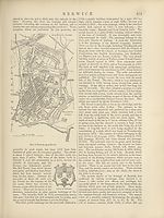
resident. The total rental of the corporation’s property
is now about <£10,800. Since the Municipal Reform Act,
1835, the borough has been governed by six aldermen and
eighteen councillors; and in 1842 “the power of life
and death ” was removed from the Quarter Sessions
to the Newcastle Assizes. The custom of specially men¬
tioning Berwick-on-Tweed after Wales, though abandoned
in Acts of Parliament, is still retained in certain proclama¬
tions. The title of “ county in itself ” also helps to recall
its ancient history. It is the seat of a Poor Law Union,
and the rateable value of the borough (1875) is £53,195.
Berwick has sent two members to the English parliament
since the reign of Mary. The registered electors number
1285, of whom 368 may vote as freemen, about 200 being
doubly qualified. Population in 1871, 8731, or, including
the conjoined townships (Tweedmouth, 2809, and Spittal,
1742), 13,282.
Of the origin or early history of Berwick nothing is known. It
probably sprung into importance during the long struggle between
the Scots and Saxons for the possession of Lothian and the Merse.
Egfrid, king of Northumbria, seeking to extend his boundary be¬
yond the Forth, was routed at Dunnichen, 685, and driven back to
the Tweed. But it was not until the battle of Carham, 1018, that
the latter river was finally secured as the boundary, and Berwick
obtained the frontier position to which it owes its fame. It seems
rapidly to have grown in size, wealth, and influence. Its name
occurs as a royal burgh in the reign of Alexander I., along with
Edinburgh, Roxburgh, and Stirling, and with them, from David I.,
it elected the tribunal which from their number was called the
“Court of the Four Burghs.” The castle of Berwick was one of
the strongholds given up to Henry II. of England to be security for
the homage due by William the Lion as the price of his liberty,
but it was restored with the others by Richard Cceur-de-Lion in
1189. At Berwick took place several of the conferences held be¬
tween Edward I. and the competitors for the Scottish crown, and
his decision in favour of Baliol was given in the castle, Nov. 1292.
Four years later Edward marched north to punish his rebellious
vassal, and began his invasion by an attack upon the town which
was at once the key of the kingdom and its commercial capital.
The English king, familiar with the place, and infuriated by the
repulse of his fleet in the river, led the land attack in person. Being
very slightly fortified the town was speedily stormed, and no mercy
was shown to the inhabitants. One memorable incident is recounted.
A company of trading Flemings held out against the besiegers in
their fortified building, the Red Hall, until it was set on fire. They
were bound by their charter to defend it to the last extremity
against the English, and they perished in the flames. Berwick
never recovered commercially from the massacre and pillage of this
terrible Good Friday. Its efforts again to rise were hindered by
the ever-renewed Border warfare, and it gradually sunk to the rank
of an ordinary market-town.
On Edward’s return from his victorious march through Scotland,
he determined to make the town impregnable with stone walls, but
before his commands could be accomplished it was recaptured by
the Scots as a consequence of the English defeat at Stirling Bridge.
On Edward’s approach the following year, however, the Scots re¬
tired, and during the remainder of his reign it continued in the
hands of the English. Here, in 1305, one quarter of Wallace’s
body was exposed, and shortly afterwards the countess of Buchan
was suspended in a cage from one of the castle towers, as a punish¬
ment for courageously performing the privilege of her family by
placing the crown on King Robert Bruce at Scone. Edward II.
spent the winter of 1310 at Berwick after an ineffectual invasion of
Scotland. Here, too, on June 11, 1314, the great English army
assembled which was defeated a fortnight later at Bannockburn.
J n 1318 the town, now well fortified, was captured by Bruce, through
the help of one of the garrison ; a siege by Edward, which followed,
rendered famous by the engines employed both in the river and
land attacks, was not successful. It remained in the hands of the
Scots till 1333, when it was besieged by Edward III., and the hope
of relief by the Scottish army being disappointed by their defeat
at Halidon Hill, about 2 miles from Berwick, the town and castle
were immediately, according to agreement, delivered up to
the English king. The next 130 years saw Berwick occasionally
attacked by the Scots, and sometimes with success, but they held
it only for short periods until 1461, when Henry VI., in gratitude
for refuge after the battle of Towton, made it over to them. In
1482, during the disputes between James III. and his nobles, it
surrendered to the English army, and was never retaken by the
Scots. Henceforward it occupied in Scotland, in relation to Eng¬
land, the position for long of Calais in France—an important strong¬
hold, the sole remnant of wide-spread conquest. This position
explains the possession by Berwick, until the union of the crowns,
of a civil and military establishment (with lord-chancellor, lord-
chamberlain, Domesday Book, governors of town and castle, &c.)
resembling that of a small kingdom. It was that appointed by
Edward I. for all Scotland, and was ready to expand, as it had been
compelled to contract its sphere, should more territory be again
acquired north of the Tweed.
BERWICKSHIRE, a maritime county of Scotland,
forming its S.E. extremity, bounded N.E. by the German
Ocean, N. by Haddington, W. by Midlothian, S.W. by
Roxburgh, S. by the Tweed, which separates it from
Northumberland, and S.E. by the liberties of the town of
Berwick. Its greatest length from E. to W. is 31^ miles;
its greatest breadth 19 J; area about 464 square miles, or
297,161 acres. It is naturally divided into three districts,
Lauderdale, or the valley of the Leader, in the W. ;
Lammermuir, the upland district occupied by the hills of
that name, in the N.; and the Merse (probably a corruption
of “March” or borderland), the largest district, occupying
the S.E. of the county. The Lammermuirs are a range of
round-backed hills, whose average height is about 1000 feet,
while the highest summit, Sayrs Law, reaches 1753 feet.
From these hills the Merse stretches to the S. and E., and
is a comparatively level tract of country, traversed, however,
from N.W. to S.E. by distinct parallel ridges. The coast
line is lofty, rocky, and precipitous, broken by ravines,
and not accessible, except at Eyemouth harbour, for small
vessels, and at one or two other places for fishing-boats.
St Abb’s Head, a peninsular promontory with a light¬
house upon it, rises to nearly 300 feet. The Eye is the
only river of the county which falls into the sea. The
others—the Leader, the Eden, the Leet, and the Whiteadder
with its tributaries, the Blackadder and the Dye—all flow
into the Tweed. Of these the largest and most important
is the Whiteadder, which has its source on the East-Lothian
side of the Lammermuirs, and, following a sinuous course
of 35 miles, falls into the Tweed within the “ Bounds ” of
Berwick. The climate of Berwickshire is chiefly influenced
by its maritime position. The winter is seldom severe in
the lowland districts; but spring is generally a trying
season on account of the east winds, which often continue
into summer. Drainage has remedied the former excessive
humidity, and the climate is now excellent, in relation
both to the health of the inhabitants and to the growth of
vegetation.
Berwickshire, geologically, consists of Silurian rocks in
the hilly region, Devonian or Old Red Sandstone in the south¬
west, and carboniferous limestone in the Merse. Large
masses of porphyritic and trap rock occasionally occur, of
which St Abb’s Head is an example. The sea-cliff to the
north-west of the mouth of the Eye is formed of con¬
glomerate or pudding-stone. There is an interesting and
somewhat famous geological appearance at a point called
Siccar, near Cockburnspath, where the sea has laid open
very plainly the junction of the primary and secondary strata.
The soils of Berwickshire are extremely various. On
the same farm a great diversity may be found. Along the
rivers is a deep rich loam, resting on gravel or clay, chiefly
the former. The less valuable clay soil of the Merse has
been much improved by the effective system of drainage
which is everywhere carried out. The more sandy and
gravelly soils are suitable for the turnip crops, which are a
marked agricultural feature of the county. To these soils
the landlords and tenants of Berwickshire have applied
themselves with such intelligence, mutual good-will,
liberality, and spirit, that the county now stands in the first
rank in regard to agriculture. The farms are large, and
are commonly held by a nineteen years’lease. Nowhere is
farming conducted more scientifically or with better success.
According to the agricultural returns for 1874, the total
acreage under all kinds of crops, bare fallow, and grass,
BERWICK
resident. The total rental of the corporation’s property
is now about <£10,800. Since the Municipal Reform Act,
1835, the borough has been governed by six aldermen and
eighteen councillors; and in 1842 “the power of life
and death ” was removed from the Quarter Sessions
to the Newcastle Assizes. The custom of specially men¬
tioning Berwick-on-Tweed after Wales, though abandoned
in Acts of Parliament, is still retained in certain proclama¬
tions. The title of “ county in itself ” also helps to recall
its ancient history. It is the seat of a Poor Law Union,
and the rateable value of the borough (1875) is £53,195.
Berwick has sent two members to the English parliament
since the reign of Mary. The registered electors number
1285, of whom 368 may vote as freemen, about 200 being
doubly qualified. Population in 1871, 8731, or, including
the conjoined townships (Tweedmouth, 2809, and Spittal,
1742), 13,282.
Of the origin or early history of Berwick nothing is known. It
probably sprung into importance during the long struggle between
the Scots and Saxons for the possession of Lothian and the Merse.
Egfrid, king of Northumbria, seeking to extend his boundary be¬
yond the Forth, was routed at Dunnichen, 685, and driven back to
the Tweed. But it was not until the battle of Carham, 1018, that
the latter river was finally secured as the boundary, and Berwick
obtained the frontier position to which it owes its fame. It seems
rapidly to have grown in size, wealth, and influence. Its name
occurs as a royal burgh in the reign of Alexander I., along with
Edinburgh, Roxburgh, and Stirling, and with them, from David I.,
it elected the tribunal which from their number was called the
“Court of the Four Burghs.” The castle of Berwick was one of
the strongholds given up to Henry II. of England to be security for
the homage due by William the Lion as the price of his liberty,
but it was restored with the others by Richard Cceur-de-Lion in
1189. At Berwick took place several of the conferences held be¬
tween Edward I. and the competitors for the Scottish crown, and
his decision in favour of Baliol was given in the castle, Nov. 1292.
Four years later Edward marched north to punish his rebellious
vassal, and began his invasion by an attack upon the town which
was at once the key of the kingdom and its commercial capital.
The English king, familiar with the place, and infuriated by the
repulse of his fleet in the river, led the land attack in person. Being
very slightly fortified the town was speedily stormed, and no mercy
was shown to the inhabitants. One memorable incident is recounted.
A company of trading Flemings held out against the besiegers in
their fortified building, the Red Hall, until it was set on fire. They
were bound by their charter to defend it to the last extremity
against the English, and they perished in the flames. Berwick
never recovered commercially from the massacre and pillage of this
terrible Good Friday. Its efforts again to rise were hindered by
the ever-renewed Border warfare, and it gradually sunk to the rank
of an ordinary market-town.
On Edward’s return from his victorious march through Scotland,
he determined to make the town impregnable with stone walls, but
before his commands could be accomplished it was recaptured by
the Scots as a consequence of the English defeat at Stirling Bridge.
On Edward’s approach the following year, however, the Scots re¬
tired, and during the remainder of his reign it continued in the
hands of the English. Here, in 1305, one quarter of Wallace’s
body was exposed, and shortly afterwards the countess of Buchan
was suspended in a cage from one of the castle towers, as a punish¬
ment for courageously performing the privilege of her family by
placing the crown on King Robert Bruce at Scone. Edward II.
spent the winter of 1310 at Berwick after an ineffectual invasion of
Scotland. Here, too, on June 11, 1314, the great English army
assembled which was defeated a fortnight later at Bannockburn.
J n 1318 the town, now well fortified, was captured by Bruce, through
the help of one of the garrison ; a siege by Edward, which followed,
rendered famous by the engines employed both in the river and
land attacks, was not successful. It remained in the hands of the
Scots till 1333, when it was besieged by Edward III., and the hope
of relief by the Scottish army being disappointed by their defeat
at Halidon Hill, about 2 miles from Berwick, the town and castle
were immediately, according to agreement, delivered up to
the English king. The next 130 years saw Berwick occasionally
attacked by the Scots, and sometimes with success, but they held
it only for short periods until 1461, when Henry VI., in gratitude
for refuge after the battle of Towton, made it over to them. In
1482, during the disputes between James III. and his nobles, it
surrendered to the English army, and was never retaken by the
Scots. Henceforward it occupied in Scotland, in relation to Eng¬
land, the position for long of Calais in France—an important strong¬
hold, the sole remnant of wide-spread conquest. This position
explains the possession by Berwick, until the union of the crowns,
of a civil and military establishment (with lord-chancellor, lord-
chamberlain, Domesday Book, governors of town and castle, &c.)
resembling that of a small kingdom. It was that appointed by
Edward I. for all Scotland, and was ready to expand, as it had been
compelled to contract its sphere, should more territory be again
acquired north of the Tweed.
BERWICKSHIRE, a maritime county of Scotland,
forming its S.E. extremity, bounded N.E. by the German
Ocean, N. by Haddington, W. by Midlothian, S.W. by
Roxburgh, S. by the Tweed, which separates it from
Northumberland, and S.E. by the liberties of the town of
Berwick. Its greatest length from E. to W. is 31^ miles;
its greatest breadth 19 J; area about 464 square miles, or
297,161 acres. It is naturally divided into three districts,
Lauderdale, or the valley of the Leader, in the W. ;
Lammermuir, the upland district occupied by the hills of
that name, in the N.; and the Merse (probably a corruption
of “March” or borderland), the largest district, occupying
the S.E. of the county. The Lammermuirs are a range of
round-backed hills, whose average height is about 1000 feet,
while the highest summit, Sayrs Law, reaches 1753 feet.
From these hills the Merse stretches to the S. and E., and
is a comparatively level tract of country, traversed, however,
from N.W. to S.E. by distinct parallel ridges. The coast
line is lofty, rocky, and precipitous, broken by ravines,
and not accessible, except at Eyemouth harbour, for small
vessels, and at one or two other places for fishing-boats.
St Abb’s Head, a peninsular promontory with a light¬
house upon it, rises to nearly 300 feet. The Eye is the
only river of the county which falls into the sea. The
others—the Leader, the Eden, the Leet, and the Whiteadder
with its tributaries, the Blackadder and the Dye—all flow
into the Tweed. Of these the largest and most important
is the Whiteadder, which has its source on the East-Lothian
side of the Lammermuirs, and, following a sinuous course
of 35 miles, falls into the Tweed within the “ Bounds ” of
Berwick. The climate of Berwickshire is chiefly influenced
by its maritime position. The winter is seldom severe in
the lowland districts; but spring is generally a trying
season on account of the east winds, which often continue
into summer. Drainage has remedied the former excessive
humidity, and the climate is now excellent, in relation
both to the health of the inhabitants and to the growth of
vegetation.
Berwickshire, geologically, consists of Silurian rocks in
the hilly region, Devonian or Old Red Sandstone in the south¬
west, and carboniferous limestone in the Merse. Large
masses of porphyritic and trap rock occasionally occur, of
which St Abb’s Head is an example. The sea-cliff to the
north-west of the mouth of the Eye is formed of con¬
glomerate or pudding-stone. There is an interesting and
somewhat famous geological appearance at a point called
Siccar, near Cockburnspath, where the sea has laid open
very plainly the junction of the primary and secondary strata.
The soils of Berwickshire are extremely various. On
the same farm a great diversity may be found. Along the
rivers is a deep rich loam, resting on gravel or clay, chiefly
the former. The less valuable clay soil of the Merse has
been much improved by the effective system of drainage
which is everywhere carried out. The more sandy and
gravelly soils are suitable for the turnip crops, which are a
marked agricultural feature of the county. To these soils
the landlords and tenants of Berwickshire have applied
themselves with such intelligence, mutual good-will,
liberality, and spirit, that the county now stands in the first
rank in regard to agriculture. The farms are large, and
are commonly held by a nineteen years’lease. Nowhere is
farming conducted more scientifically or with better success.
According to the agricultural returns for 1874, the total
acreage under all kinds of crops, bare fallow, and grass,
Set display mode to:
![]() Universal Viewer |
Universal Viewer | ![]() Mirador |
Large image | Transcription
Mirador |
Large image | Transcription
Images and transcriptions on this page, including medium image downloads, may be used under the Creative Commons Attribution 4.0 International Licence unless otherwise stated. ![]()
| Encyclopaedia Britannica > Encyclopaedia Britannica > Volume 3, Athens-BOI > (624) Page 612 |
|---|
| Permanent URL | https://digital.nls.uk/193658413 |
|---|
| Attribution and copyright: |
|
|---|---|
| Shelfmark | EB.17 |
|---|---|
| Description | Ten editions of 'Encyclopaedia Britannica', issued from 1768-1903, in 231 volumes. Originally issued in 100 weekly parts (3 volumes) between 1768 and 1771 by publishers: Colin Macfarquhar and Andrew Bell (Edinburgh); editor: William Smellie: engraver: Andrew Bell. Expanded editions in the 19th century featured more volumes and contributions from leading experts in their fields. Managed and published in Edinburgh up to the 9th edition (25 volumes, from 1875-1889); the 10th edition (1902-1903) re-issued the 9th edition, with 11 supplementary volumes. |
|---|---|
| Additional NLS resources: |
|