Encyclopaedia Britannica > Volume 21, ROT-Siam
(200) Page 190 - SAI
Download files
Complete book:
Individual page:
Thumbnail gallery: Grid view | List view
190 S A I-
540 miles from South America, in 29° 15' W. long. Their
outline is irregular, and as they are only separated by
narrow but deep chasms they have the appearance of being
one island. The whole space occupied does not exceed 1400
feet in length by about half as much in breadth. Besides
sea-fowl—two species of noddy (Anous stolidus and Anous
melanogenys) and a booby or gannet (Sulci leucogcisteu') -
the only terrestrial inhabitants are insects and spiders.
Fish are abundant, seven species (one, Holocentrum sancti
pauli, peculiar to the locality) being collected by the
“ Challenger ” during a brief stay. Darwin (On Volcanic
Islands, p. 32) decided that St Paul’s Rocks were not
of volcanic origin; more modern investigators—Renard,
A. Geikie, and Wadsworth—maintain that they probably
are eruptive. See Reports of. the Voyage of H.M.S. Chal¬
lenger : Narrative of the Cruise, vol. i.
ST PETER PORT, the capital of the island of Guernsey
(q.v.); its population was 16,658 in 1881.
ST PETERSBURG, a government of north-western
Russia, at the head of the Gulf of Finland, stretching
along its south-eastern shore and the southern shore of
Lake Ladoga. It is bounded by Finland and Olonetz on
the FT., Novgorod and Pskoff on the E. and S., Esthonia
and Livonia on the W., and has an area of 20,750 square
miles. It is hilly only on its Finland border, the re¬
mainder being flat and covered with marshy forests, with
the exception of a plateau of about 350 feet high in the
south, the Duderhof hills at Krasnoye Selo reaching 550
feet. A great number of parallel ridges of glacier origin
intersect the government towards Lake Peipus and north¬
wards of the Neva. Silurian and Devonian rocks appear
in the south, the whole covered by a thick glacial deposit
with boulders (bottom moraine) and by thick alluvial de¬
posits in the valley of the Neva. The government skirts
the Gulf of Finland for 130 miles. The bays of Cronstadt,
Koporye, Luga, and Narva afford good anchorage, but the
coast is for the most part lined with reefs and sandbanks;
to the east of Cronstadt the water becomes very shallow
(18 to 20 feet). The chief river is the Neva, which
receives only a few small tributaries; the Luga and the
Narova also enter the Gulf of Finland. The feeders of
Lake Ladoga—the Yolkhoff, the Syass, and the Svir, the
last two forming part of the system of canals connecting
the Neva with the Volga—are important channels of com¬
merce, as also is the Narova (see Pskoff). Marshes and
forests cover about 40 per cent, of the surface (70 per
cent, at the end of the 18th century).
The population (apart from the capital) was 635,780 in 1882,
82‘7 per cent, being Russians, 15‘0 Finns, 0-5 Esthonians, and 1‘8 per
cent. German colonists who have immigrated since 1765. Twenty
per cent, are Protestants ; the remainder mostly belong to the Greek
Church ; but there are also more than 20,000 Nonconformists, about
6000 Catholics, and 1500 Jews. Agriculture is at a low stage and
very unproductive ; the Germans, however, get advantage from it.
The Finns rear cattle to some extent. Manufactures are especially
developed in the districts of Tsarskoye Selo and Yamburg,—cottons,
silks, paper, ironware, and machinery (at Kolpino) being the chief
products. Several large manufacturing establishments—especially
at Cronstadt—are maintained by the state for military purposes.
The government is subdivided into eight districts, the chief towns
of which are St Petersburg (see below), Gdoff (3150 inhabitants),
Luga (1650), Novaya Ladoga (4100), Peterhof (7950), Schlusselburg
(10,400), and Yamburg (3250). Gatchina (10,100), Narva (8610),
Oranienbaum (3600), and Pavlovsk (3400) have no districts. Cron¬
stadt and the capital form separate governorships. Okhta, Kolpino,
Pulkova, and Krasnoye Selo, though without municipal institutions,
are worthy of mention.
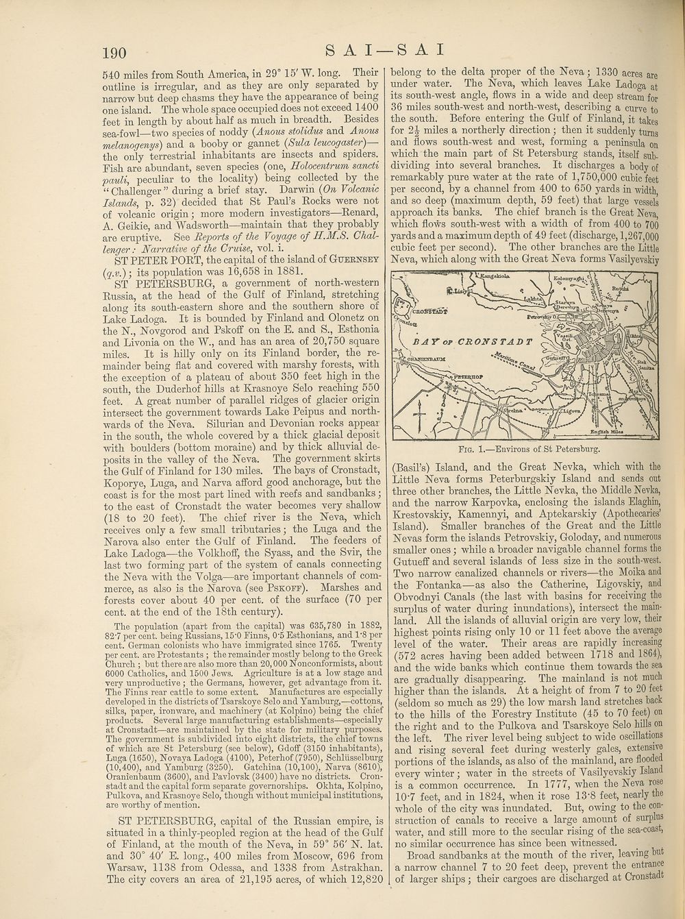
ST PETERSBURG, capital of the Russian empire, is
situated in a thinly-peopled region at the head of the Gulf
of Finland, at the mouth of the Neva, in 59° 56' N. lat.
and 30° 40' E. long., 400 miles from Moscow, 696 from
Warsaw, 1138 from Odessa, and 1338 from Astrakhan.
The city covers an area of 21,195 acres, of which 12,820
-S A I
belong to the delta proper of the Neva; 1330 acres are
under water. The Neva, which leaves Lake Ladoga at
its south-west angle, flows in a wide and deep stream for
36 miles south-west and north-west, describing a curve to
the south. Before entering the Gulf of Finland, it takes
for 2 Jr miles a northerly direction; then it suddenly turns
and flows south-west and west, forming a peninsula on
which the main part of St Petersburg stands, itself sub¬
dividing into several branches. It discharges a body of
remarkably pure water at the rate of 1,750,000 cubic feet
per second, by a channel from 400 to 650 yards in width
and so deep (maximum depth, 59 feet) that large vessels
approach its banks. The chief branch is the Great Neva
which flows south-west with a width of from 400 to 700
yards and a maximum depth of 49 feet (discharge, 1,267,000
cubic feet per second). The other branches are the Little
Neva, which along with the Great Neva forms Yasilyevskiy
Fig. 1.—Environs of St Petersburg.
(Basil’s) Island, and the Great Nevka, which with the
Little Neva forms Peterburgskiy Island and sends out
three other branches, the Little Nevka, the Middle Nevka,
and the narrow Karpovka, enclosing the islands Elaghin,
Krestovskiy, Kamennyi, and Aptekarskiy (Apothecaries’
Island). Smaller branches of the Great and the Little
Nevas form the islands Petrovskiy, Goloday, and numerous
smaller ones; while a broader navigable channel forms the
Gutueff and several islands of less size in the south-west.
Two narrow canalized channels or rivers—the Moika and
the Fontanka—as also the Catherine, Ligovskiy, and
Obvodnyi Canals (the last with basins for receiving the
surplus of water during inundations), intersect the main¬
land. All the islands of alluvial origin are very low, their
highest points rising only 10 or 11 feet above the average
level of the water. Their areas are rapidly increasing
(572 acres having been added between 1718 and 1864),
and the wide banks which continue them towards the sea
are gradually disappearing. The mainland is not much
higher than the islands. At a height of from 7 to 20 feet
(seldom so much as 29) the low marsh land stretches back
to the hills of the Forestry Institute (45 to 70 feet) on
the right and to the Pulkova and Tsarskoye Selo hills on
the left. The river level being subject to wide oscillations
and rising several feet during westerly gales, extensive
portions of the islands, as also of the mainland, are flooded
every winter; water in the streets of Yasilyevskiy Island
is a common occurrence. In 1777, when the Neva rose
10'7 feet, and in 1824, when it rose IS’S feet, nearly the
whole of the city was inundated. But, owing to the con¬
struction of canals to receive a large amount of surplus
water, and still more to the secular rising of the sea-coast,
no similar occurrence has since been witnessed.
Broad sandbanks at the mouth of the river, leaving but
a narrow channel 7 to 20 feet deep, prevent the entrance
of larger ships ; their cargoes are discharged at Cronstadt
540 miles from South America, in 29° 15' W. long. Their
outline is irregular, and as they are only separated by
narrow but deep chasms they have the appearance of being
one island. The whole space occupied does not exceed 1400
feet in length by about half as much in breadth. Besides
sea-fowl—two species of noddy (Anous stolidus and Anous
melanogenys) and a booby or gannet (Sulci leucogcisteu') -
the only terrestrial inhabitants are insects and spiders.
Fish are abundant, seven species (one, Holocentrum sancti
pauli, peculiar to the locality) being collected by the
“ Challenger ” during a brief stay. Darwin (On Volcanic
Islands, p. 32) decided that St Paul’s Rocks were not
of volcanic origin; more modern investigators—Renard,
A. Geikie, and Wadsworth—maintain that they probably
are eruptive. See Reports of. the Voyage of H.M.S. Chal¬
lenger : Narrative of the Cruise, vol. i.
ST PETER PORT, the capital of the island of Guernsey
(q.v.); its population was 16,658 in 1881.
ST PETERSBURG, a government of north-western
Russia, at the head of the Gulf of Finland, stretching
along its south-eastern shore and the southern shore of
Lake Ladoga. It is bounded by Finland and Olonetz on
the FT., Novgorod and Pskoff on the E. and S., Esthonia
and Livonia on the W., and has an area of 20,750 square
miles. It is hilly only on its Finland border, the re¬
mainder being flat and covered with marshy forests, with
the exception of a plateau of about 350 feet high in the
south, the Duderhof hills at Krasnoye Selo reaching 550
feet. A great number of parallel ridges of glacier origin
intersect the government towards Lake Peipus and north¬
wards of the Neva. Silurian and Devonian rocks appear
in the south, the whole covered by a thick glacial deposit
with boulders (bottom moraine) and by thick alluvial de¬
posits in the valley of the Neva. The government skirts
the Gulf of Finland for 130 miles. The bays of Cronstadt,
Koporye, Luga, and Narva afford good anchorage, but the
coast is for the most part lined with reefs and sandbanks;
to the east of Cronstadt the water becomes very shallow
(18 to 20 feet). The chief river is the Neva, which
receives only a few small tributaries; the Luga and the
Narova also enter the Gulf of Finland. The feeders of
Lake Ladoga—the Yolkhoff, the Syass, and the Svir, the
last two forming part of the system of canals connecting
the Neva with the Volga—are important channels of com¬
merce, as also is the Narova (see Pskoff). Marshes and
forests cover about 40 per cent, of the surface (70 per
cent, at the end of the 18th century).
The population (apart from the capital) was 635,780 in 1882,
82‘7 per cent, being Russians, 15‘0 Finns, 0-5 Esthonians, and 1‘8 per
cent. German colonists who have immigrated since 1765. Twenty
per cent, are Protestants ; the remainder mostly belong to the Greek
Church ; but there are also more than 20,000 Nonconformists, about
6000 Catholics, and 1500 Jews. Agriculture is at a low stage and
very unproductive ; the Germans, however, get advantage from it.
The Finns rear cattle to some extent. Manufactures are especially
developed in the districts of Tsarskoye Selo and Yamburg,—cottons,
silks, paper, ironware, and machinery (at Kolpino) being the chief
products. Several large manufacturing establishments—especially
at Cronstadt—are maintained by the state for military purposes.
The government is subdivided into eight districts, the chief towns
of which are St Petersburg (see below), Gdoff (3150 inhabitants),
Luga (1650), Novaya Ladoga (4100), Peterhof (7950), Schlusselburg
(10,400), and Yamburg (3250). Gatchina (10,100), Narva (8610),
Oranienbaum (3600), and Pavlovsk (3400) have no districts. Cron¬
stadt and the capital form separate governorships. Okhta, Kolpino,
Pulkova, and Krasnoye Selo, though without municipal institutions,
are worthy of mention.
ST PETERSBURG, capital of the Russian empire, is
situated in a thinly-peopled region at the head of the Gulf
of Finland, at the mouth of the Neva, in 59° 56' N. lat.
and 30° 40' E. long., 400 miles from Moscow, 696 from
Warsaw, 1138 from Odessa, and 1338 from Astrakhan.
The city covers an area of 21,195 acres, of which 12,820
-S A I
belong to the delta proper of the Neva; 1330 acres are
under water. The Neva, which leaves Lake Ladoga at
its south-west angle, flows in a wide and deep stream for
36 miles south-west and north-west, describing a curve to
the south. Before entering the Gulf of Finland, it takes
for 2 Jr miles a northerly direction; then it suddenly turns
and flows south-west and west, forming a peninsula on
which the main part of St Petersburg stands, itself sub¬
dividing into several branches. It discharges a body of
remarkably pure water at the rate of 1,750,000 cubic feet
per second, by a channel from 400 to 650 yards in width
and so deep (maximum depth, 59 feet) that large vessels
approach its banks. The chief branch is the Great Neva
which flows south-west with a width of from 400 to 700
yards and a maximum depth of 49 feet (discharge, 1,267,000
cubic feet per second). The other branches are the Little
Neva, which along with the Great Neva forms Yasilyevskiy
Fig. 1.—Environs of St Petersburg.
(Basil’s) Island, and the Great Nevka, which with the
Little Neva forms Peterburgskiy Island and sends out
three other branches, the Little Nevka, the Middle Nevka,
and the narrow Karpovka, enclosing the islands Elaghin,
Krestovskiy, Kamennyi, and Aptekarskiy (Apothecaries’
Island). Smaller branches of the Great and the Little
Nevas form the islands Petrovskiy, Goloday, and numerous
smaller ones; while a broader navigable channel forms the
Gutueff and several islands of less size in the south-west.
Two narrow canalized channels or rivers—the Moika and
the Fontanka—as also the Catherine, Ligovskiy, and
Obvodnyi Canals (the last with basins for receiving the
surplus of water during inundations), intersect the main¬
land. All the islands of alluvial origin are very low, their
highest points rising only 10 or 11 feet above the average
level of the water. Their areas are rapidly increasing
(572 acres having been added between 1718 and 1864),
and the wide banks which continue them towards the sea
are gradually disappearing. The mainland is not much
higher than the islands. At a height of from 7 to 20 feet
(seldom so much as 29) the low marsh land stretches back
to the hills of the Forestry Institute (45 to 70 feet) on
the right and to the Pulkova and Tsarskoye Selo hills on
the left. The river level being subject to wide oscillations
and rising several feet during westerly gales, extensive
portions of the islands, as also of the mainland, are flooded
every winter; water in the streets of Yasilyevskiy Island
is a common occurrence. In 1777, when the Neva rose
10'7 feet, and in 1824, when it rose IS’S feet, nearly the
whole of the city was inundated. But, owing to the con¬
struction of canals to receive a large amount of surplus
water, and still more to the secular rising of the sea-coast,
no similar occurrence has since been witnessed.
Broad sandbanks at the mouth of the river, leaving but
a narrow channel 7 to 20 feet deep, prevent the entrance
of larger ships ; their cargoes are discharged at Cronstadt
Set display mode to:
![]() Universal Viewer |
Universal Viewer | ![]() Mirador |
Large image | Transcription
Mirador |
Large image | Transcription
Images and transcriptions on this page, including medium image downloads, may be used under the Creative Commons Attribution 4.0 International Licence unless otherwise stated. ![]()
| Encyclopaedia Britannica > Encyclopaedia Britannica > Volume 21, ROT-Siam > (200) Page 190 - SAI |
|---|
| Permanent URL | https://digital.nls.uk/193629879 |
|---|
| Attribution and copyright: |
|
|---|---|
| Shelfmark | EB.17 |
|---|---|
| Description | Ten editions of 'Encyclopaedia Britannica', issued from 1768-1903, in 231 volumes. Originally issued in 100 weekly parts (3 volumes) between 1768 and 1771 by publishers: Colin Macfarquhar and Andrew Bell (Edinburgh); editor: William Smellie: engraver: Andrew Bell. Expanded editions in the 19th century featured more volumes and contributions from leading experts in their fields. Managed and published in Edinburgh up to the 9th edition (25 volumes, from 1875-1889); the 10th edition (1902-1903) re-issued the 9th edition, with 11 supplementary volumes. |
|---|---|
| Additional NLS resources: |
|