Download files
Complete book:
Individual page:
Thumbnail gallery: Grid view | List view

14
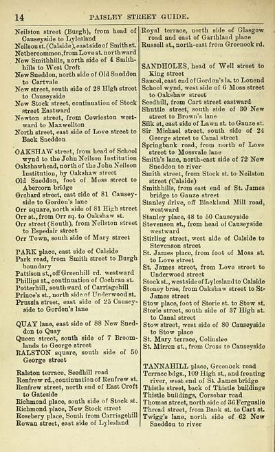
PAISLEY STREET GUIDE.
Neilston street (Burgh), from head of
Causeyside to Lylesland
Neilson st. (Calside), east side of Smith st.
Nethercommon,f rom Love st. northward
New Smithhills, north side of 4 Smith-
hills to West Croft
New Sneddon, north side of Old Sneddon
to Cartvale
New street, south side of 28 High street
to Causeyside
New Stock street, continuation of Stock
street Eastward
Newton street, from Cowieston west-
ward to Maxwellton
North street, east side of Love street to
Back Sneddon
OAKSHAW street, from head of School
wynd to the John Neilson Institution
Oakshawhead, north of the John Neilson
Institution, by Oakshaw street
Old Sneddon, foot of Moss street to
Abercorn bridge
Orchard street, east side of 81 Causey-
side to Gordon's lane
Orr square, north side of 81 High street
Orr st., from Orr sq. to Oakshaw st.
Orr street (South), from Neilston street
to Espedair street
Orr Town, south side of Mary street
PARK place, east side of Calside
Park road, from Smith street to Burgh
boundary
Pattisonst.,offGreenhill rd. westward
Phillips st., continuation of Cochran st.
Potterhill, southward of Carriagehill
Prince's st., north side of Underwood st.
Prussia street, east side of 25 Causey-
side to Gordon's lane
QUAY lane, east side of 88 New Sned-
don to Quay
Queen street, south side of 7 Broom-
lands to George street
RALSTON square, south side of 50
George street
Ralston terrace, Seedhill road
Renfrew rd., continuation of Benfrew st.
Renfrew street, north end of East Croft
to Gateside
Richmond place, south side of Stock st.
Richmond place, New Stock street
Rosebery place, South from Carriagehill
Rowan street, east side of Lylesland
Royal terrace, north side of Glasgow
road and east of Garthland place
Russell st., north-east from Greenock rd.
SANDHOLES, head of Well street to
King street
Saucel, east end of Gordon's la. to Lonend
School wynd, west side of 6 Moss street
to Oakshaw street
Seedhill, from Cart street eastward
Shuttle street, south side of 30 New
street to Brown's lane
Silk st, east side of Lawn st. to Gauze st.
Sir Michael street, south side of 24
George street to Canal street
Springbank road, from north of Love
street to Mossvale lane
Smith's lane, north-east side of 72 New
Sneddon to river
Smith street, from Stock st. to Neilston
street (Calside)
Smithhills, from east end of St. James
bridge to Gauze street
Stanley drive, off Blackland Mill road,
westward
Stanley place, 48 to 50 Causeyside
Stevenson st., from head of Causeyside
westward
Stirling street, west side of Calside to
Stevenson street
St. James place, from foot of Moss st.
to Love street
St. James street, from Love street to
Underwood street
Stock st., west side of Lylesland to Calside
Stoney brae, from Oakshaw street to St'
James street
Stow place, foot of Storie st. to Stow st.
Storie street, south side of 37 High st.
to Canal street
Stow street, west side of 80 Causeyside
to Stow place
St. Mary terrace, Colinslee
St. Mirren st., from Cross to Causeyside
TANNAHILL place, Greenock road
Terrace bdgs., 109 High st., and fronting
river, west end of St. James bridge
Thistle street, back of Thistle buildings
Thistle buildings, Corsebar road
Thomas street, north side of 36Ferguslie
Thread street, from Bank st. to Cart st.
Twigg's lane, north side of 62 New
Sneddon to river
Set display mode to: Large image | Transcription
Images and transcriptions on this page, including medium image downloads, may be used under the Creative Commons Attribution 4.0 International Licence unless otherwise stated. ![]()
| Scottish Post Office Directories > Towns > Paisley > Paisley directory and general advertiser > 1890-1991 > (20) |
|---|
| Permanent URL | https://digital.nls.uk/85973107 |
|---|
| Description | For 1890-91. |
|---|---|
| Attribution and copyright: |
|
| Description | Directories of individual Scottish towns and their suburbs. |
|---|
| Description | Around 700 Scottish directories published annually by the Post Office or private publishers between 1773 and 1911. Most of Scotland covered, with a focus on Edinburgh, Glasgow, Dundee and Aberdeen. Most volumes include a general directory (A-Z by surname), street directory (A-Z by street) and trade directory (A-Z by trade). |
|---|


