Download files
Complete book:
Individual page:
Thumbnail gallery: Grid view | List view
ALMANAC AND TIDE TABLE.
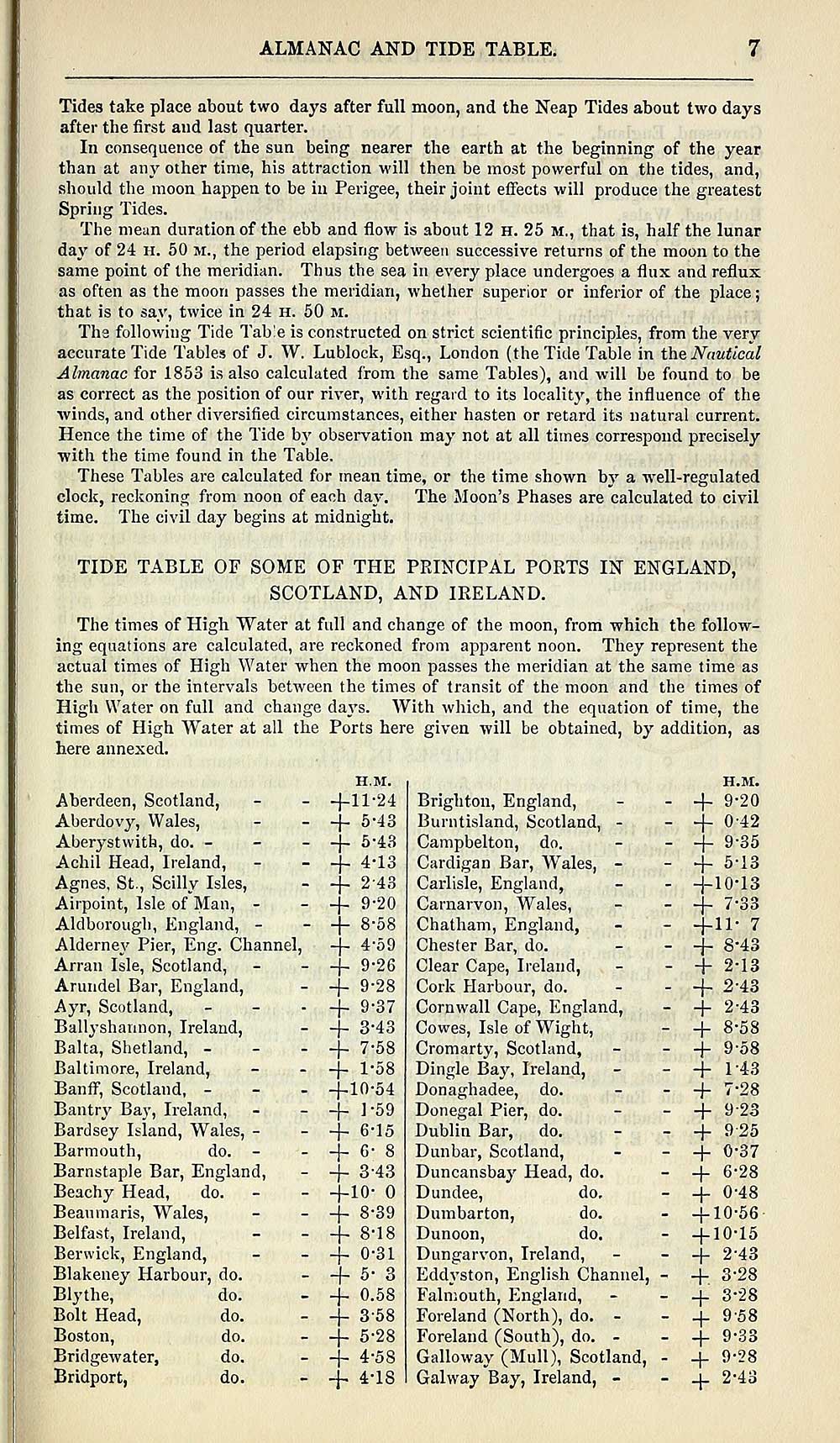
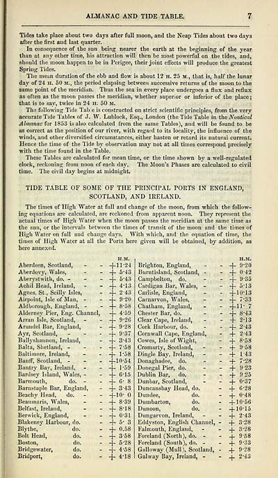
Tides take place about two days after full moon, and the Neap Tides about two days
after the first and last quarter.
In consequence of the sun being nearer the earth at the beginning of the year
than at any other time, his attraction will then be most powerful on the tides, and,
should the moon happen to be in Perigee, their joint effects will produce the greatest
Spring Tides.
The mean duration of the ebb and flow is about 12 H. 25 M., that is, half the lunar
day of 24 H. 50 m., the period elapsing between successive returns of the moon to the
same point of the meridian. Thus the sea in every place undergoes a flux and reflux
as often as the moon passes the meridian, whether superior or inferior of the place ;
that is to say, twice in 24 h. 50 m.
The following Tide Tab!e is constructed on strict scientific principles, from the very
accurate Tide Tables of J. W. Lublock, Esq., London (the Tide Table in the Nautical
Almanac for 1853 is also calculated from the same Tables), and will be found to be
as correct as the position of our river, with regard to its locality, the influence of the
■winds, and other diversified circumstances, either hasten or retard its natural current.
Hence the time of the Tide by observation may not at all times correspond precisely
with the time found in the Table.
These Tables are calculated for mean time, or the time shown by a well-regulated
clock, reckoning from noon of each day. The Moon's Phases are calculated to civil
time. The civil day begins at midnight.
TIDE TABLE OF SOME OF THE PRINCIPAL PORTS IN ENGLAND,
SCOTLAND, AND IRELAND.
The times of High "Water at full and change of the moon, from which the follow-
ing equations are calculated, are reckoned from apparent noon. They represent the
actual times of High Water when the moon passes the meridian at the same time as
the sun, or the intervals between the times of transit of the moon and the times of
High Water on full and change days. With which, and the equation of time, the
times of High W T ater at all the Ports here given will be obtained, by addition, as
here annexed.
H.M.
Aberdeen, Scotland, - - -f-11-24
Aberdovy, Wales, - - — j— 5*43
Aberystwith, do. - - - -j- 5-43
Achil Head, Ireland, - - -j- 4*13
Agnes, St., Scilly Isles, - + 2 ' 43
Airpoint, Isle of*Man, - - -f 9*20
Aldborough, England, - - -j- 8*58
Alderney Pier, Eng. Channel, -j- 4'59
Arran Isle, Scotland, - - -f- 9 ' 26
Arundel Bar, England, - + 9 ' 28
Ayr, Scotland, ■ + 9 " 37
Ballyshannon, Ireland, - -j- 3 - 43
Balta, Shetland, - - + 7-58
Baltimore, Ireland, - -j- 1-58
Banff, Scotland, - -f" 10-54
Bantrj' Bay, Ireland, - - -f- 1 "59
Bardsey Island, Wales, - - -f- 6-15
Barmouth, do. - - -j- 6 - 8
Barnstaple Bar, England, - -f- 3 - 43
Beachy Head, do. - - -f 10 " °
Beaumaris, Wales, - - -\- 8*39
Belfast, Ireland, - - -f 8'18
Berwick, England, - - + °' 31
Blakeney Harbour, do. - -f- 5* 3
Blythe, do. - -j- °- 58
Bolt Head, do. - -j- 358
Boston, do. - -}- 5 ' 28
Bridgewater, do. - -}- 4-5S
Bridport, do. - -f 4-18
Brighton, England,
Burntisland, Scotland, -
Campbelton, do.
Cardigan Bar, Wales, -
Carlisle, England,
Carnarvon, Wales,
Chatham, England,
Chester Bar, do.
Clear Cape, Ireland,
Cork Harbour, do.
Cornwall Cape, England,
Cowes, Isle of Wight,
Cromarty, Scotland,
Dingle Bay, Ireland,
Donaghadee, do.
Donegal Pier, do.
Dublin Bar, do.
Dunbar, Scotland,
Duncansbay Head, do.
Dundee, do,
Dumbarton, do.
Dunoon, do.
Dungarvon, Ireland,
Eddyston, English Channel,
Falmouth, England,
Foreland (North), do. -
Foreland (South), do. -
Galloway (Mull), Scotland,
Galway Bay, Ireland, -
H.M.
+
9-20
+
0-42
+
9-35
+
513
+
10-13
+
7-33
+11- 7
+
8-43
+
2-13
+
2-43
+
2-43
+
8-58
+
9-58
+
143
+
7-28
+
923
+
925
+
0-37
+
6-28
+
0-48
+
0-56
+
0-15
+
2-43
+.
3-28
+
3-28
+
9-58
+
9-33
+
9-28
+
2-43
Set display mode to: Large image | Transcription
Images and transcriptions on this page, including medium image downloads, may be used under the Creative Commons Attribution 4.0 International Licence unless otherwise stated. ![]()
| Scottish Post Office Directories > Towns > Glasgow > Post-Office annual Glasgow directory > 1853-1854 > (27) |
|---|
| Permanent URL | https://digital.nls.uk/84108696 |
|---|
| Description | Post-Office annual Glasgow directory 1853-1854 |
|---|---|
| Shelfmark | NH.675-676 |
| Additional NLS resources: | |
| Attribution and copyright: |
|
| Description | Glasgow : Printed by J. Graham for the letter-carriers of the Post-Office, 1828-? Imprint and title vary. [Varying forms of title: Glasgow Post-Office directory, Glasgow Post-Office annual directory, Post Office Glasgow annual directory.] |
|---|---|
| Shelfmark | Various |
| Description | Directories of individual Scottish towns and their suburbs. |
|---|
| Description | Around 700 Scottish directories published annually by the Post Office or private publishers between 1773 and 1911. Most of Scotland covered, with a focus on Edinburgh, Glasgow, Dundee and Aberdeen. Most volumes include a general directory (A-Z by surname), street directory (A-Z by street) and trade directory (A-Z by trade). |
|---|