Volume 6
(127) Page 568
Download files
Individual page:
Thumbnail gallery: Grid view | List view

568
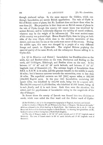
through sheltered valleys. In the same manner the Calders, which run
through Lanarkshire, are merely British appellations. The vale of Clyde is
full of British names of places, but Mr. Lockhart does not know them when he
sees them (d). His proposition is that there are no British names of places in
the vale of Clyde, though this country till recent times was inhabited by
ancient Britons; and he incidentally disputes the validity of record evidence,
whatever may be the weight of its influences (e). The most ancient name
of this country was y-strad-cluyd. Hence Strath-Clyde, from its lying on both
sides of the river Clyde, which rises in the southern mountains of this
district, and runs into the sea at the north-west corner of the county. During
the middle ages, this name was changed by a people of a very different
lineage and speech to Clydes-dale. The original Britons prefixing the
essential quality of the name Strath, and the subsequent Saxons adding it in
Cljdes-dale.
� II. Of its Situation and Extent.] Lanarkshire has Dumfries-shire on the
south, Ayr and Renfrew shires on the west, Dunbarton and Stirling on the
north, and Linlithgow, Edinburgh, and Peebles shires on the east. It lies
between 55� 18' 40" and 55� 56' north latitude, and between 3� 24' 25"
longitude west of Greenwich (f). The extreme length of Lanarkshire from
S.S.E. to N.N.W. is 54 miles, and the greatest breadth in the middle is nearly
32 miles; but it becomes narrower towards the extremities, even to less than
10 miles. The superficial contents are 927 [888] square miles, or 593,380
[564,283] English acres. In the year ]821 Lanarkshire, containing 927
square miles, was inhabited by 244,766 souls, being 2G4 to a square mile.
The 244,766 composed 51,578 families, who inhabited 47,068 houses, being 4�
in each family, and 51/5 in each house. Such then were the situation, the
extent, and the populousness of Lanarkshire owing- to the magnitude of the
city of Glasgow.
In former times the county of Lanark was formed into two divisions or
wards, which were called the Over ward and the Nether ward of Clydes-
(d)  See Caledonia, i. ch. 1, for the comparative topography of England, Scotland, and Ireland.
(e)  See the charters of Malcolm IV. and William in the Chart, of Glasgow, "De decimis Solvendis,"
which are addressed to the Welsh dwelling in Strath-Clyde.    See Caledonia, bk. ii., ch. 2 :  " Of the
Romanized Britons of the Cumbrian kingdom in North Britain," for showing how groundless are Mr.
Lockhart's notions of there having been a Strath-Clyde kingdom.
(/) The city of Glasgow stands in 55� 51' 35" north latitude, and 4� 16' 10" longitude west of
Greenwich. The town of Lanark stands in 55� 4L' north latitude, and 3� 48' longitude west of
Greenwich.
Set display mode to:
![]() Universal Viewer |
Universal Viewer | ![]() Mirador |
Large image | Transcription
Mirador |
Large image | Transcription
Images and transcriptions on this page, including medium image downloads, may be used under the Creative Commons Attribution 4.0 International Licence unless otherwise stated. ![]()
| Caledonia, or, An account, historical and topographic of North Britain from the most ancient to the present times > Volume 6 > (127) Page 568 |
|---|
| Permanent URL | https://digital.nls.uk/74531284 |
|---|---|
| Description | Of its situation and extent |
| Description | Vol. VI. |
|---|---|
| Attribution and copyright: |
|

