Volume 5
(54) Page 48
Download files
Individual page:
Thumbnail gallery: Grid view | List view

48
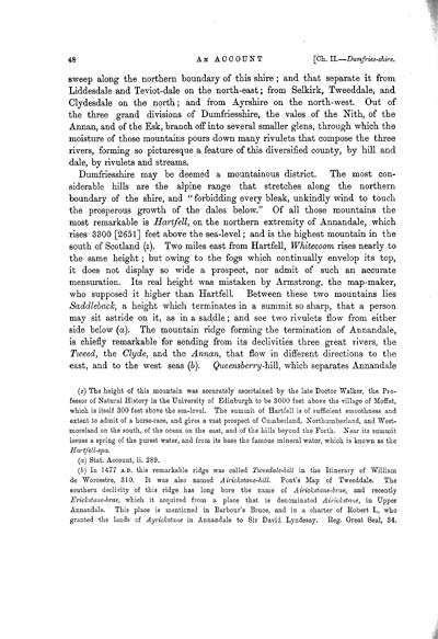
sweep along the northern boundary of this shire; and that separate it from
Liddesdale and Teviot-dale on the north-east; from Selkirk, Tweeddale, and
Clydesdale on the north; and from Ayrshire on the north-west. Out of
the three grand divisions of Dumfriesshire, the vales of the Nith, of the
Annan, and of the Esk, branch off into several smaller glens, through which the
moisture of those mountains pours down many rivulets that compose the three
rivers, forming so picturesque a feature of this diversified county, by hill and
dale, by rivulets and streams.
Dumfriesshire may be deemed a mountainous district. The most con-
siderable hills are the alpine range that stretches along the northern
boundary of the shire, and " forbidding every bleak, unkindly wind to touch
the prosperous growth of the dales below." Of all those mountains the
most remarkable is Hartfell, on the northern extremity of Annandale, which
rises 3300 [2651] feet above the sea-level; and is the highest mountain in the
south of Scotland (z). Two miles east from Hartfell, Whitecoom rises nearly to
the same height; but owing to the fogs which continually envelop its top,
it does not display so wide a prospect, nor admit of such an accurate
mensuration. Its real height was mistaken by Armstrong, the map-maker,
who supposed it higher than Hartfell. Between these two mountains lies
Saddleback, a height which terminates in a summit so sharp, that a person
may sit astride on it, as in a saddle; and see two rivulets flow from either
side below (a). The mountain ridge forming the termination of Annandale,
is chiefly remarkable for sending from its declivities three great rivers, the
Tweed, the Clyde, and the Annan, that flow in different directions to the
east, and to the west seas (b). Queensberry-hill, which separates Annandale
(z) The height of this mountain was accurately ascertained by the late Doctor Walker, the Pro-
fessor of Natural History in the University of Edinburgh to be 3000 feet above the village of Moffat,
which is itself 300 feet above the sea-level. The summit of Hartfell is of sufficient smoothness and
extent to admit of a horse-race, and gives a vast prospect of Cumberland, Northumberland, and West-
moreland on the south, of the ocean on the east, and of the hills beyond the Forth. Near its summit
issues a spring of the purest water, and from its base the famous mineral water, which is known as the
Hartfell-spa.
(a) Stat. Account, ii. 289.
(b) In 1477 A.D. this remarkable ridge was called Tweedale-hill in the Itinerary of William
de Worcestre, 310. It was also named Airickstane-hill. Pont's Map of Tweeddale. The
southern declivity of this ridge has long bore the name of Airickstane-brae, and recently
Erickstane-brae, which it acquired from a place that is denominated Airickstane, in Upper
Annandale. This place is mentioned in Barbour's Bruce, and in a charter of Robert I., who
granted the lands of Ayrickstane in Annandale to Sir David Lyndesay. Reg. Great Seal, 34.
Set display mode to:
![]() Universal Viewer |
Universal Viewer | ![]() Mirador |
Large image | Transcription
Mirador |
Large image | Transcription
Images and transcriptions on this page, including medium image downloads, may be used under the Creative Commons Attribution 4.0 International Licence unless otherwise stated. ![]()
| Caledonia, or, An account, historical and topographic of North Britain from the most ancient to the present times > Volume 5 > (54) Page 48 |
|---|
| Permanent URL | https://digital.nls.uk/74530232 |
|---|---|
| Description | Vol. V. |
|---|---|
| Attribution and copyright: |
|

