Volume 3
(412) Page 399
Download files
Individual page:
Thumbnail gallery: Grid view | List view

399
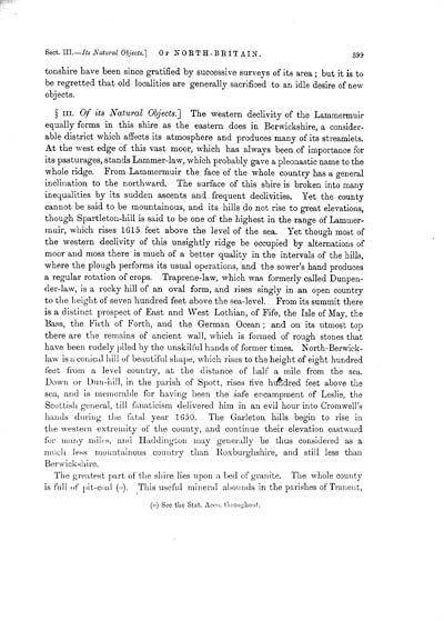
tonshire have been since gratified by successive surveys of its area ; but it is to
be regretted that old localities are generally sacrificed to an idle desire of new
objects.
� III. Of its Natural Objects.] The western declivity of the Lammermuir
equally forms in this shire as the eastern does in Berwickshire, a consider-
able district which affects its atmosphere and produces many of its streamlets.
At the west edge of this vast moor, which has always been of importance for
its pasturages, stands Lammer-law, which probably gave a pleonastic name to the
whole ridge. From Lammermuir the face of the whole country has a general
inclination to the northward. The surface of this shire is broken into many
inequalities by its sudden ascents and frequent declivities. Yet the county
cannot be said to be mountainous, and its hills do not rise to great elevations,
though Spartleton-hill is said to be one of the highest in the range of Lammer-
muir, which rises 1615 feet above the level of the sea. Yet though most of
the western declivity of this unsightly ridge be occupied by alternations of
moor and moss there is much of a better quality in the intervals of the hills,
where the plough performs its usual operations, and the sower's hand produces
a regular rotation of crops. Traprene-law, which was formerly called Dunpen-
der-law, is a rocky hill of an oval form, and rises singly in an open country
to the height of seven hundred feet above the sea-level. From its summit there
is a distinct prospect of East and West Lothian, of Fife, the Isle of May, the
Bass, the Firth of Forth, and the German Ocean ; and on its utmost top
there are the remains of ancient wall, which is formed of rough stones that
have been rudely piled by the unskilful hands of former times. North-Berwick-
law is a conical bill of beautiful shape, which rises to the height of eight hundred
feet from a level country, at the distance of half a mile from the sea.
Down or Dun-hill, in the parish of Spott, rises five hundred feet above the
sea, and is memorable for having been the safe encampment of Leslie, the
Scottish general, till fanaticism delivered him in an evil hour into Cromwell's
hands during the fatal year 1650. The Garleton hills begin to rise in
the western extremity of the county, and continue their elevation eastward
for many miles, and Haddington may generally be thus considered as a
much less mountainous country than Roxburghshire, and still less than
Berwickshire.
The greatest part of the shire lies upon a bed of granite. The whole county
is full of pit-coal (o). This useful mineral abounds in the parishes of Tranent,
(o] See the Stat. Acco. throughout.
Set display mode to:
![]() Universal Viewer |
Universal Viewer | ![]() Mirador |
Large image | Transcription
Mirador |
Large image | Transcription
Images and transcriptions on this page, including medium image downloads, may be used under the Creative Commons Attribution 4.0 International Licence unless otherwise stated. ![]()
| Caledonia, or, An account, historical and topographic of North Britain from the most ancient to the present times > Volume 3 > (412) Page 399 |
|---|
| Permanent URL | https://digital.nls.uk/74528898 |
|---|---|
| Description | Of its natural objects |
| Description | Vol. III. |
|---|---|
| Attribution and copyright: |
|

