Army lists > Monthly army lists > 1914-1918 > November 1913
(1070)
Download files
Complete book:
Individual page:
Thumbnail gallery: Grid view | List view
1<
THE ABMY LIST ADVEBTISER.
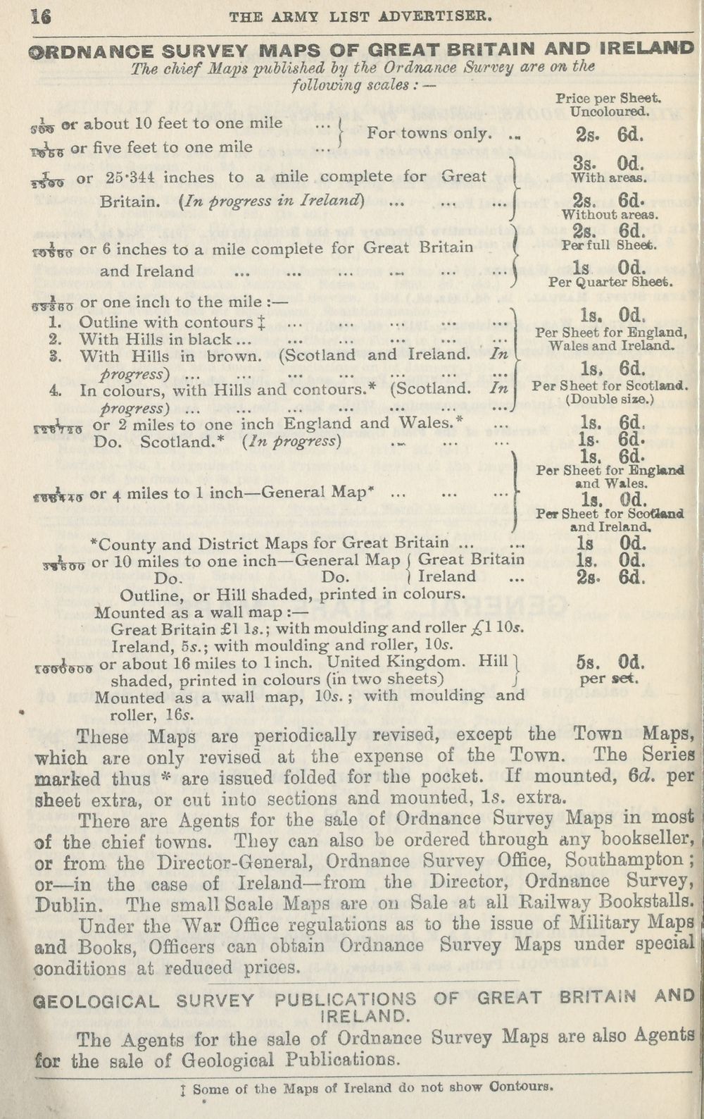
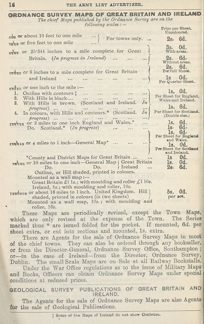
ORDNANCE SURVEY MAPS OF GREAT BRITAIN AND IRELAND
The chief Maps puUishfid by the Oidname Survey are on the
following scales: —
stw
)
»r about 10 feet to one mile
ri^-g or five feet to one mile
y^^5 or 25"34t inches to a mile complete
Britain. {In progress in Ireland)
For towns only.
for
ireat
fvivrs or 6 inches to a mile complete for Great Britain
and Ireland
g^gg or one inch to the mile :—
1. Outline with contours J ... ... ...
2. With Hills in black
3. With Hills in brown. (Scotland and Ireland. In
progress') ...
4. In colours, with Hills and contours.* (Scotland. In
progress) ...
iVts or 2 miles to one inch England and Wales.*
Do. Scotland.* (In progress) ._
rre
tv^ns or 4 miles to 1 inch—General Map*
Price per Sheet,
Unooloured.
2s. 6d.
3s. Od.
With areas.
2s. 6d-
Without are€i3.
28. 6d.
Per full Sheet.
Is Od.
Per Quarter Sheet.
Is. Od.
Per Sheet for England,
W^ales and Ireland.
Is. 6d.
Per Sheet for Scotland.
(Double size.)
Is. 6d.
Is- 6d.
Is. 6d.
Per Sheet for England
and Wales.
Is. Od.
Per Sheet for Scotland
and Ireland,
Is Od.
Is. Od.
2s. 6d.
I
*County and District Maps for Great Britain
TiVwu or 10 miles to one inch—General Map j Great Britain
Do. Do. ) Ireland
Outline, or Hill shaded, printed in colours.
Mounted as a wall map :—
Great Britain £1 Is.; with moulding and roller £110s.
Ireland, 5s.; with moulding- and roller, 10.9.
iffs^sns or about 16 miles to 1 inch. United Kingdom. Hill | 5g. Od.
shaded, printed in colours (in two sheets) j per act.
Mounted as a wall map, 10^. ; with moulding and
roller, 16s.
These Maps are periodically revised, except the Town Maps
■which are only revised at the expense of the Town. The Seriei
marked thus * are issued folded for the pocket. If mounted, 6d. pel
sheet extra, or cut into sections and mounted. Is, extra.
There are Agents for the sale of Ordnance Survey Maps in most
of the chief towns. They can also be ordered through any bookseller,
or from the Director-General, Ordnance Survey Office, Southampton ;
or—in the case of Ireland—from the Director, Ordnance Survey,
Dublin. The small Scale Maps are on Sale at all Railway Bookstalls.
Under the War Office regulations as to the issue of Military Maps
and Books, Officers can obtain Ordnance Survey Maps under special
conditions at reduced prices.
GEOLOGICAL SURVEY PUBLICATIONS OF GREAT BRITAIN AND
IRELAND.
The Agents for the sale of Ordnance Survey Maps are also Agents
lor the sale of Geological Publications.
I Some of the Maps of Ireland do not show Contours.
THE ABMY LIST ADVEBTISER.
ORDNANCE SURVEY MAPS OF GREAT BRITAIN AND IRELAND
The chief Maps puUishfid by the Oidname Survey are on the
following scales: —
stw
)
»r about 10 feet to one mile
ri^-g or five feet to one mile
y^^5 or 25"34t inches to a mile complete
Britain. {In progress in Ireland)
For towns only.
for
ireat
fvivrs or 6 inches to a mile complete for Great Britain
and Ireland
g^gg or one inch to the mile :—
1. Outline with contours J ... ... ...
2. With Hills in black
3. With Hills in brown. (Scotland and Ireland. In
progress') ...
4. In colours, with Hills and contours.* (Scotland. In
progress) ...
iVts or 2 miles to one inch England and Wales.*
Do. Scotland.* (In progress) ._
rre
tv^ns or 4 miles to 1 inch—General Map*
Price per Sheet,
Unooloured.
2s. 6d.
3s. Od.
With areas.
2s. 6d-
Without are€i3.
28. 6d.
Per full Sheet.
Is Od.
Per Quarter Sheet.
Is. Od.
Per Sheet for England,
W^ales and Ireland.
Is. 6d.
Per Sheet for Scotland.
(Double size.)
Is. 6d.
Is- 6d.
Is. 6d.
Per Sheet for England
and Wales.
Is. Od.
Per Sheet for Scotland
and Ireland,
Is Od.
Is. Od.
2s. 6d.
I
*County and District Maps for Great Britain
TiVwu or 10 miles to one inch—General Map j Great Britain
Do. Do. ) Ireland
Outline, or Hill shaded, printed in colours.
Mounted as a wall map :—
Great Britain £1 Is.; with moulding and roller £110s.
Ireland, 5s.; with moulding- and roller, 10.9.
iffs^sns or about 16 miles to 1 inch. United Kingdom. Hill | 5g. Od.
shaded, printed in colours (in two sheets) j per act.
Mounted as a wall map, 10^. ; with moulding and
roller, 16s.
These Maps are periodically revised, except the Town Maps
■which are only revised at the expense of the Town. The Seriei
marked thus * are issued folded for the pocket. If mounted, 6d. pel
sheet extra, or cut into sections and mounted. Is, extra.
There are Agents for the sale of Ordnance Survey Maps in most
of the chief towns. They can also be ordered through any bookseller,
or from the Director-General, Ordnance Survey Office, Southampton ;
or—in the case of Ireland—from the Director, Ordnance Survey,
Dublin. The small Scale Maps are on Sale at all Railway Bookstalls.
Under the War Office regulations as to the issue of Military Maps
and Books, Officers can obtain Ordnance Survey Maps under special
conditions at reduced prices.
GEOLOGICAL SURVEY PUBLICATIONS OF GREAT BRITAIN AND
IRELAND.
The Agents for the sale of Ordnance Survey Maps are also Agents
lor the sale of Geological Publications.
I Some of the Maps of Ireland do not show Contours.
Set display mode to: Large image | Transcription
Images and transcriptions on this page, including medium image downloads, may be used under the Creative Commons Attribution 4.0 International Licence unless otherwise stated. ![]()
| British Military lists > Army lists > Monthly army lists > 1914-1918 > November 1913 > (1070) |
|---|
| Permanent URL | https://digital.nls.uk/104705389 |
|---|
| Shelfmark | GWB.71 |
|---|---|
| Additional NLS resources: | |
| Attribution and copyright: |
|
| Description | These lists cover 1913 to 1919 inclusive, and 1937 to 1940 inclusive. This series of monthly army lists were produced from 1815-1940. |
|---|---|
| Shelfmark | GWB.71 |
| Additional NLS resources: |
| Description | Military lists recording details of officers who served in the three main branches of Britain's armed services during the First and Second World Wars. Official lists for the British Army, Royal Navy and Royal Air Force have been published since the 18th, 19th and early 20th centuries respectively. Also includes unofficial 'Hart's Army Lists' of British Army and, from 1862, Indian Army Officers published between 1839 and 1915. |
|---|---|