Download files
Complete book:
Individual page:
Thumbnail gallery: Grid view | List view

10
FROM POOLE TO LYME REGIS.
Bmte 1.
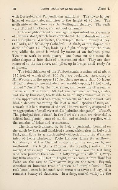
with Decorated and Perpendicular additions. The tower is, per¬
haps, of earlier date, and rises to the height of 80 feet. The
north aisle of the choir was the Godlington chantry. The walls
were of great thickness, and without ornament.
In the neighbourhood of Swanage lie upwards of sixty quarries
of Purbeck stone, which have contributed the materials employed
in St. Stephen’s, Winchester, the Temple Church, Romsey Abbey,
St. Paul’s, and Salisbury Cathedral. A shaft, or pit, sloping to a
depth of about 120 feet, leads by a flight of steps into the quar¬
ries, while the stone is raised by means of an inclined plane.
Two men work in each quany,—one hews out the stone, the
other shapes it into slabs of a convenient size. They are then
removed to the sea shore, and piled up in heaps, until ready for
shipment.
The total thickness of the Purbeck strata is estimated at about
275 feet, of which about 100 feet are workable. According to
Mr. Webster, in the upper 125 feet there are more than 50 layers
of useful stone; these include a remarkable deposit, 12 feet thick,
termed “ Cinder ” by the quarrymen, and consisting of a regular
oyster-bed. The lower 150 feet are composed of clays, shales,
and shelly limestone, too friable to be of any commercial value.
“ The uppermost bed is a green, calcareous, and for the most part
friable deposit, containing shells of a small species of unis, and
beneath this is a stratum of the well-known marble, composed of
an aggregation of small river-shells (paludina elongata) ”—Mantell.
The principal fossils found in the Purbeck strata are river-shells,
drifted land-plants, bones of saurian and chelonian reptiles, with
the remains of fishes and crustaceans.
The Isle of Purbeck is, in fact, a peninsula, bounded on
the north by the small Luckford stream, which rises in Lulworth
Park, and flows in a north-easterly direction into the Wareham
inlet of Poole Harbour. Poole Harbour forms its north-east
boundary; and the Channel washes it on the east, south, and
south-west. Its length is 12 miles ; its breadth, 7 miles. For¬
merly, it was a royal deer-forest, and James I. was the last king
who here pursued the chase. A lofty range of chalk hills, vary¬
ing from 500 to 700 feet in height, runs across it from Handfast
Point on the east, to Worbarrow Bay on the west. Beyond,
stretches an immense tract of brown and purple heath. The
rock-bound coast is indented with numerous coves and bays of a
romantic beauty of character. In a deep, central valley lie the
Set display mode to:
![]() Universal Viewer |
Universal Viewer | ![]() Mirador |
Large image | Transcription
Mirador |
Large image | Transcription
| Antiquarian books of Scotland > Adventure and adventurers > Black's guide to the counties of Dorset, Devon, & Cornwall > (30) |
|---|
| Permanent URL | https://digital.nls.uk/142586738 |
|---|
| Description | Thousands of printed books from the Antiquarian Books of Scotland collection which dates from 1641 to the 1980s. The collection consists of 14,800 books which were published in Scotland or have a Scottish connection, e.g. through the author, printer or owner. Subjects covered include sport, education, diseases, adventure, occupations, Jacobites, politics and religion. Among the 29 languages represented are English, Gaelic, Italian, French, Russian and Swedish. |
|---|

