Topographical, statistical, and historical gazetteer of Scotland > Volume 2
(24) Page 14 - INS
Download files
Complete book:
Individual page:
Thumbnail gallery: Grid view | List view

INS
14
INV
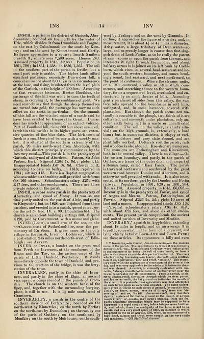
INSCH, a parish in the district of Garioch, Aber-
deenshire ; bounded on the north by the water of
TJrie, which divides it from Drumblade andForgue;
on the east by Culsalmond ; on the south by Kem-
nay; and on the west by Kinnethmont and Gartly.
Its figure approaches to a square ; length 5 miles ;
breadth 3 ; square area 7,500 acres. Houses 270.
Assessed property, in 1815, £2,360. Population, in
1801, 798 ; in 1831, 1,338 ; in 1836, 1,365. The soil
in the southern part of the parish is fertile; but a
small part only is arable. The higher lands afford
excellent pasturage, especially Dun-o-deer hill, a
conical eminence about 3,000 yards in circumference
at the base, and rising, insulated from the level plain
of the Garioch, to the height of 300 feet. According
to that veracious historian, Hector Boethius, the
pasturage of this hill was wont to turn the teeth of
sheep, in cropping it, to the semblance of gold. We
need scarcely say that though the sheep themselves
are turned into gold, the pasturage has now no such
effect on the teeth in particular. On the summit
of this hill are the vitrified ruins of a castle said to
have been erected by Gregory the Great. Dun-o-
deer has much the appearance of an extinct volcano.
Part of Foudland hill, rising 300 feet above sea-level,
is within this parish : in its higher parts are exten-
sive quarries of fine blue slate. The kirk-town of
Insch is a small burgh -of-barony with a weekly mar-
ket : it is situated at the southern extremity of the
parish, 26 miles north-west from Aberdeen, with
which this district principally communicates by the
Inverury canal This parish is in the presbytery of
Garioch, and synod of Aberdeen. Patron, Sir John
Forbes, Bart. Stipend £204 7s. 9d. ; glebe £15.
Unappropriated teinds £47 0s. 9d. Church built,
according to date on belfry, in 1613; repaired in
1794; sittings 413. Here is a Baptist congregation
who assemble in a thrashing-mill provided with forms
for 160 sitters. Schoolmaster's salary £27, with
£17 fees, and other emoluments. There are three
private schools in the parish.
INSCH, a quoad sacra parish in the presbytery of
Abernethy, and synod of Moray. It was at one
time partly united to the parish of Alvie, and partly
to Kingussie ; but, in 1828, was disjoined from these
parishes, and erected into a parish, quoad sacra, un-
der the act 5° Geo. IV. c. 90. Population 644. The
church is an ancient building; sittings 300. Stipend
£120, paid by Government, with a manse and glebe.
INVER (Loch), a small arm of the sea, on the
north-west coast of Sutherlandshire, near the pro-
montory of Ru-Stoer. It gives name to the only
village in the parish, Inver or Lochinver, which is
a post-station, 245 miles north-north-west of Edin-
burgh : see Assynt.
INVER, or Invar, a hamlet on the great road
from Perth to Inverness, at the confluence of the
Braan and the Tay, on the eastern verge of the
parish of Little Dunkeld, Perthshire. It stands
immediately opposite the town of Dunkeld, and, pre-
vious to the erection of the bridge, it was the ferry-
station of the town.
INVERALLEN, partly in the shire of Inver-
ness, and partly in the shire of Elgin, an ancient
vicarage now comprehended in the parish of Crom-
dale. The church is on the western bank of the
Spey, and, together with the surrounding burying-
place, is still in use. It is If mile south-west of
Grantown.
INVERARITY, a parish in the centre of the
southern division of Forfarshire ; bounded on the
north-west by Kinnettles ; on the north by Forfar ;
on the north-east by Dunnichen ; on the east by one
of the parts of Guthrie ; on the south-east by
Monikie ; on the south by Muirhouse ; on the south-
west by Tealing ; and on the west by Glammis. In
outline, it approaches the figure of a circle ; and, in
measurement, it is about 4^ or 4| miles in diameter.
Arity water, a large tributary of Dean water — so
large, and so greatly longer in course than that slug-
gish drain of Loch- Forfar, as to be really the parent
stream — comes in upon the parish from the east, and
intersects it right through the middle ; and about
halfway across it is joined on its left bank by Corbi-
burn, which rises in several head- waters at and be-
yond the south-western boundary, and comes bend-
ingly round, first eastward, and next northward, to
the point of confluence. Where the streams unite,
or a little eastward, a valley or little strath com-
mences, and stretching thence to the western boun-
dary, forms a sequestered level, overlooked and en-
cinctured by an amphitheatre of hills. Ascending
gently on almost all sides from this valley, the sur-
face rolls upward to the boundaries in soft hills,
variegated, and, in some instances, covered with
plantation. But though the parish seems not na-
turally favourable to the plough, two-thirds of it are
cultivated, and one-sixth under plantation, only an-
other sixth being left in a waste or uncultivated
condition. The soil, in the valley, is chiefly allu-
vial ; on the high grounds, is, extensively, a hard
loam ; but, in numerous districts, is clayey or vari-
ous. Sandstone and grey slate abound, and are
plentifully worked. Dotterels visit the parish ; rails
and woodcocks also abound. Roe-deer are numerous.
The mansions are Fotheringham and Kincaldrum,
both in the central valley. There is no village On
the eastern boundary, and partly in the parish of
Guthrie, are traces of the outer ditch and rampart of
a Roman camp, called ' Haer Faads.' The parish
is traversed northward and southward by the great
western road between Dundee and Aberdeen, and is
otherwise well provided with roads. It is also inter-
sected in its northern part by the Dundee and Forfar
railway. Population, in 1801, 820; in 1831,904.
Houses 173. Assessed property, in 1815, £6,093
Inverarity is in the presbytery of Forfar, and synod
of Angus and Mearns. Patron, Fotheringham of
Powrie. Stipend £226 2s. 5d. ; glebe 10 acres of
land and a manse. Unappropriated teinds £65 13s.
— Parochial schoolmaster's salary £34 4s. 44d.,
with about £25 fees, and about £7 other emolu-
ments. The present parish comprehends the ancient
and united parishes of Inverarity and Meathie.
INVERARY,* a parish in Argyleshire, extending
about 18 miles in length, and on an average 3 in
breadth, somewhat in the form of a crescent, and
lying chiefly betwixt Loch- Awe and Loch-Fyne :
see these articles. Its appearance is hilly and even
* " Inveraray, — in Gaelic, Ion-ar-ao-reidh, — is the modern
name of the parish. The appellations by which it was formerly
distinguished, viz., Kilmilieu and Gleneray, were either given
in consequence of its being the cell of some monk, or from a
glen which forms a considerable part of the district. The river
which runs by Inveraray, — in Gaelic, Ao-reidh, — is a contrac-
tion of ao, a privative, ' not,' and reidh, * smooth.' This etymo-
logy suits with the appearance of some parts of the river at this
day, and was very applicable to the whole of it before its chan-
nel was cleared. Ao-reidh, is evidently contrasted with Sio-
reidh, 'always smooth,' — the name of another river near the
town, remarkable for its smoothness. From Ao-reidh, is de-
rived Glenao-reidh, the valley through which the river passes,
and Ion-ar-ao-reidh, the flat ground on both sides the mouth of
the river. It is probable, that agriculture was first attempted
on such fertile Bpots as were thus situated. The name univer-
sally given in Gaelic to such pieces of ground, favours this idea.
lon-ar, or Inver, means, 'worthy of tillage,' from ion, 'de-
serving of,' and ar, ( to till.' Ion-ar-ao-reidh, may therefore
signify * a piece of flat fertile ground at the mouth of a rapid
rough river;' or, aorath, may signify unlucky, from the fre-
quent accidental drownings which may be supposed to have
happened in a rapid rough river, before bridges were built on
it, and which, from the contiguity of the hills, is apt to be
overflowed in a very short space of time, an instance of which
happened on the 3d of August, 1792, when, in consequence of a
high flood, salmon and trout were caught on the very roads
and meadows."— Old Statistical Account.
Set display mode to: Large image | Transcription
Images and transcriptions on this page, including medium image downloads, may be used under the Creative Commons Attribution 4.0 International Licence unless otherwise stated. ![]()
| Gazetteers of Scotland, 1803-1901 > Topographical, statistical, and historical gazetteer of Scotland > Volume 2 > (24) Page 14 - INS |
|---|
| Permanent URL | https://digital.nls.uk/97494251 |
|---|
| Description | Volume second. I-Z. |
|---|---|
| Attribution and copyright: |
|

