Imperial gazeteer of Scotland, or, Dictionary of Scottish topography > Volume 2
(18) Page 6 - GOV
Download files
Complete book:
Individual page:
Thumbnail gallery: Grid view | List view

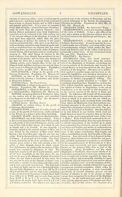
GOWANSBANK.
6
GRAMPIANS.
vicinity of numerous villas, — some of which may be
said to he in it ; and it has acquired of late years new
lines of neat or elegant houses, and in 1862 a large
and tasteful public hall. It is a place of compara-
tively high antiquity, — situated far more advantage-
ously for trade than the original Glasgow; and,
having always maintained some local importance,
insomuch as to be reckoned in the 16th century one
of the largest villages in the kingdom, it might al-
most have been expected, rather than the place
of St. Mungo, to become the nucleus of the great
modern commercial city, — the more so as that city,
without having extended many hundred yards east-
ward or northward from its original site, has come
travelling down, in a broad mass, miles of distance,
toward Govan, till it promises soon to reach and en-
compass it. The chief things of interest in the
town of Govan, have already been mentioned in our
account of the parish ; and we have only farther to
say that the town has a savings' bank, a ladies'
clothing society, and a branch-office of the city of
Glasgow bank, and that omnibuses run several times
a-day from it to Glasgow and Renfrew. Population
in 1841, 2,555 ; in 1861, 7,637. Houses, 324.
GOWANSBANK, a village in the parish of St.
Vigeans, Forfarshire. Population, 72. Houses, 22.
GOWELL, an islet in the bay of Stornoway,
island of Lewis, forming a breakwater and shelter
to Stornoway harbour.
GOWER (Pokt). See Port-Gower.
GOWKHALL, a village in the parish of Carnock,
Fifeshire. Population, 196. Houses, 34.
GOWKSHILL, a village in the parish of Cock-
pen, Edinburghshire. Population, 219. Houses, 41.
GOWRIE, an ancient district of Perthshire, lying
on the eastern side of the county, and extending
from Stormont to the frith of Tay. See Blairgow-
rie and Carse-of-Gowrie.
GOYLE (Loch). See Goil (Loch).
GRADEN, an extinct village in the parish of
Coldstream, Berwickshire.
GRADEN-BURN, a rivulet of 3 miles length of
course, in the parish of Coldstream, north-eastward
to the Tweed, at a point 2 miles above Ladykirk.
GRADEN PLACE. See Linton, Roxburghshire.
GRAEMSAY, one of the Orkney islands. It lies
in Hoy sound, immediately south-east of Hoy mouth,
A a mile south of the town of Stromness, and i a mile
east of Bow kirk in Hoy island. It is about 1 J mile
in length, and 1 in breadth. It was formerly a
vicarage, united to the ancient rectory of Hoy, and
was served by the minister of Hoy every third
Sunday ; but it neither pays stipend, nor has any
glebe. It is iu the presbytery of Cairston, and synod
of Orkney. A great part of it is arable. The whole
is level, and seems to be of an excellent soil. The
interior parts, under a thin soil, contain a bed of
schist or slate, through almost its whole extent.
Two lighthouses, for guiding the navigation of Hoy
sound, were erected in Graerasay in 1851. The
high light stands in 58° 56' 9" north latitude, and 3°
16' 33" west longtitude, is 115 feet above the sea,
and can be seen at the distance of about 10 nautical
miles ; the low light is elevated 55 feet above the
sea, and can be seen at the distance of about 7 nau-
tical miles ; and the two bear from each other south-
east i east, and north-west J west. The high light
is a lixed red light, and the low a fixed bright light.
The red light illuminates an arc from SE by E to
BE J S towards SE ; and the high tower containing
it also shows toward Stromness a bright fixed light
from SSI! J E to WSW, and towards Cara an arc
from NNW } W to N i W southerly. The low
light shows its bright fixed light from E J S to W
4 N, facing northward. The island is now under the
pastoral care of the minister of Stromness, and has
a school belonging to the Society for propagating
Christian knowledge. Population in 1831,225; in
1861, 230. Houses, 40.
GRAHAM'S DYKE. See Antoninus' Wall.
GRAHAMSTOWN, a neat and important suburb
of the town of Falkirk. It has a post office of its
own, and a station on the junction railway from the
Seottisli Central to the Edinburgh and Glasgow. See
Falkirk.
GRAHAMSTOWN, a village in the parish of
Neilston, Renfrewshire. It stands upon the Levern,
3 miles south-east of Paisley ; and is one of the chain
of manufacturing villages which render the Barr-
head and Neilston part of the valley of the Levern
practically a large town. It was commenced about
the year 1780. Population, 706.
GRAITNEY. See Gretna.
GRAMPIANS (The), that broad mountain
fringe of elevations which runs along the eastern
side of the Highlands of Scotland, overlooking the
western portions of the Lowlands, and forming the
natural barrier or boundary between the two great
divisions of the kingdom. The name is so indefin-
itely applied iu popular usage, and has been so ob-
scured by injudicious and mistaken description, as
to want the definiteness of meaning requisite to the
purposes of distinct topographical writing. The
Grampians are usually described as " a chain " of
mountains stretching from Dumbarton, or from the
hills behind Gareloch opposite Greenock, or from
the district of Cowal in Argyleshire, to the sea at
Stonehaven, or to the interior of Aberdeenshire, or
to the eastern exterior of the shores of Elgin and
Banff. No definition will include all the mountains
which claim the name, and at the same time exclude
others to which it is unknown, but one which re-
gards them simply as the mountain-front, some files
deep, which the Highlands, from their southern con-
tinental extremity to the point where their flank is
turned by a champaign country east of the Tay, pre-
sent to the Lowlands of Scotland. But thus defined,
or in fact defined in any fashion which shall not
limit them to at most two counties, they are far from
being, in the usual topographical sense of the word,
" a chain." From Cowal north-eastward to the ex-
tremity of Dumbartonshire, they rise up iu elevations
so utterly independent of one another as to admit
long separating bays between, and are of such vari-
ous forms and heights and modes of continuation as
to be at best a series of ridges and single elevations,
some of the ridges contributing their length, and
others contributing merely their breadth, to the con-
tinuation. East and north of Loch-Lomond in Stir-
lingshire, their features are so distinctive and pecu-
liar, and their amassment or congeries so overlooked
by the monarch-summit of Benlomoud, as to have
become more extensively and more appropriately
known as the Lomond hills, than as part of the
Grampians. Along Breadalbano and the whole
Highlands of Perthshire, they consist chiefly of la
feral ridges running from west to east, or from north
west to south-east, entirely separated by long tra-
versing valleys, and occasionally standing far apart
on opposite sides of long and not very narrow sheets
of water; and they even — as in the instances of Schi-
challion and Beniglo — include solitary but huge and
conspicuous monarch-mountains, which, either by
their isolatedness of position, or their remarkable
peculiarity of exterior character, possess not one
feature of alliance to any of the groups or ridges
except their occupying the confines of the Highland
territory. In the north-west and north of Forfar-
shire and the adjacent parts of Perthshire and Aber-
deenshire, they at last assume the character of a
Set display mode to: Large image | Transcription
Images and transcriptions on this page, including medium image downloads, may be used under the Creative Commons Attribution 4.0 International Licence unless otherwise stated. ![]()
| Gazetteers of Scotland, 1803-1901 > Imperial gazeteer of Scotland, or, Dictionary of Scottish topography > Volume 2 > (18) Page 6 - GOV |
|---|
| Permanent URL | https://digital.nls.uk/97470894 |
|---|
| Attribution and copyright: |
|
|---|---|

