Topographical, statistical, and historical gazetteer of Scotland > Volume 2
(419) Page 405 - MOR
Download files
Complete book:
Individual page:
Thumbnail gallery: Grid view | List view

MOR
405
MCU
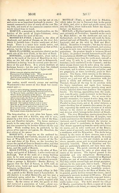
the whole county, and is seen very far out at sea,
and serves as an important landmark in storms. Its
summit commands a view of nearly all the vast Mo-
ray frith, and much of the numerous counties which
recede inland from its beach.
MORVEN, a mountain in Aberdeenshire, on the
borders of the parish of Logie-Coldstone, rising
2,700 feet above the level of the sea.
MOSSBURN-FORD, a hamlet in the shire of
Roxburgh, and parish of Oxnam, on the river Jed,
which is fordable here ; 3 miles south-east of Jed-
burgh. There is a tower here nearly entire, and
built and divided in the same manner as that at Dol-
phiston, but far inferior in strength.
MOSS-FLANDERS, an extensive district on the
north side of the river Forth, in the shire of Perth.
MOSSGIEL, a small farm-hamlet, about half-a-
mile to the north of the town of Mauchline in Ayr-
shire, on the left side of the road to Kilmarnock,
celebrated as having been for several years the resi-
dence of the poet Burns. It is utterly destitute of
landscape beauty; but the poet's fame has clothed
it with a beauty and interest of a higher order.
Hither romantic pilgrims shall betake
Themselves from distant lands. When we are still
In centuries of sleep, his fame will wake,
And his great memory with deep feelings fill
These scenes that he has trod, and hallow every hill.
Our readers would scarcely excuse our omitting
Wordsworth's fine sonnet on this bleak but conse-
crated spot : —
4C ' There !' said a stripling, pointing with much pride
Towards a low roof vvilh green trees half-concealed,
' Is Mosseiel Farm, and that's the very field
Where Burns ploughed up the Daisy ' Far and wide
A plain below stretched seaward, while, descried
Above sea-clouds, the Peaks of Arran rose j
And, by that simple notice, the repose
(if earth, sky, sea, and air, was vivified.
Benealh k the raudom bield of clod or stone, 1
Myriads of daisies have shone forth in flower
Near the lark's nest, and in their natural hour
Have passed away : less happy ihan the one
That, by the unwilling ploughshare, died to prove
The tender charm of poetry and love."
The farm-steading, a very plain low house, with
one small room and a kitchen, may still be seen,
shaded by a few trees, on the west side of the Glas-
gow and Dumfries turnpike. The house continues
nearly in the same state as when Burns occupied it,
and was tenanted by his brother Gilbert till the year
1800. While residing here, he published, by the
advice of his superior and patron, Mr. Hamilton, the
first edition of his poems.
MOSSPAUL, a stage-inn on the mailroad be-
tween Edinburgh and Carlisle, situated at the east
base of Wisp-hill, between the sources of the Te-
viot and those of the Ewes, on the boundary be-
tween the parish of Ewes in Dumfries-shire, and that
of Cavers in Roxburghshire; 9i miles north of Lang-
holm, and 12i south of Hawick.
MOSS-TOWER, a hamlet in the shire of Rox-
burgh, and parish of Eckford ; 5 miles north-east of
Jedburgh. Part of the walls of a strong building
were to be seen several years ago in this village,
which is so denominated from its situation in a marsh.
From a passage in Ridpath's ' Border History,' it
appears that the Earl of Sussex, in 1570, with an
English army, burnt and razed Moss-Tower, then
belonging to Buccleuch.
MOTHERWELL, the principal village in Dal-
ziel, a parish in the Middle ward of Lanarkshire. In
old charters it is called Moderville, and lies near a
celebrated spring called the ' Well of our Lady,'
from whicli the inhabitants are partly supplied with
water. By the census of 1841, the parish of Dal-
ziel contained a population of 1,457, — about one-
third of whom resided in the village of Motherwell.
MOTRAY (The), a small river in Fifeshire,
which takes its rise in Norman's law, in the parish
of Abdie, and, after a short and gentle course, falls
into the Eden, about half-a-mile below the Guard-
bridge .• see Kilmany.
MOULIN, a Highland parish, nearly at the north-
east extremity of Perthshire; bounded on the north
by Blair- Athole ; on the north-east and east by
Kirkmiehael; on the south-east and south by Kirk-
michael and part of Dowally ; on the south-west by
Logierait ; and on the west by Dull and Blair-
Athole. Its outline is irregular ; but may be viewed
as an oblong extending north-eastward, and sending
off from its ends two considerable north-westward
projections. Its greatest length is between 16 and
17 miles ; its greatest breadth between 8 and 9 ; and
its area between 60,000 and 70,000 acres. The river
Garry, coming down from the north-west, cuts off a
small wing li mile by f, and traces the western
boundary a mile southward to the Tummel ; and the
latter stream thence runs 3^ miles along the south-
western boundary. Both streams abound in common
river trout, and in salmon, sea-trout, and grilse; and
are gorgeously, at times terrifically, grand in their
scenery. The Garry, while running in the interior,
traverses the celebrated pass of Killiecrankie,
[which see,] and over all its connection with the
parish is wildly and sublimely impetuous. The
Tummel, though all the way to its junction with
the Garry tumultuous and rapid, here becomes
tranquilly majestic, and sweeps proudly along amid
scenery softened down from grandeur into exquisite
beauty. The Girnag, approaching from the south-
east, runs 2j miles south-westward to the Garry at
the upper end of Killiecrankie. Six or seven inde-
pendent streamlets, the largest 4 miles long, rise in
the interior, and run to the Garry and the Tummel.
Parallel to these rivers, and at 4J- miles' distance, a
water-shedding line of summits runs across the par-
ish ; separating the south-west division of it which
belongs to the district of Athole, from the north-
east division which belongs to the district of Stratb-
ardle. The river Briarachan, coming down from the
north immediately- behind this line of heights, runs
J mile southward on the boundary, and 1 1 mile south-
eastward, and 'H eastward through the interior to
the point where it contributes to form the Ardle.
The Arnate approaching from the north not far from
its source, and 5:i miles north- east of the Briara-
chan 's point of approach, runs 6i miles southward to
a confluence with the Briarachan. The Ardle being
formed by the union of these streams, runs a mile
south-eastward to its exit from the parish. In nearly
all the running waters, rills and rivulets as well as
rivers, cascades, occur, and, in several instances, are
unusually beautiful. Those at Edradour and Ur-
rard are particularly admired, and have been cele-
brated in song. The parish consists of a congeries
of hills cloven down by vales or glens along the
course of the streams. The highest ground is the
pyramidal and very conspicuous Benvrackie :
which see. The other hills, considered as Highland
heights, are not of mountainous bulk or altitude.
Yet they exhibit several high and abrupt precipices,
and are, for the most part, clad in heath. Those of
Glenfernate [which see, and see also Strath-
ardle] are exceptions, being beautifully verdant.
The arable land is level in the How of Moulin, but,
in general, gently declines toward the rivers ; and it
aggregately amounts to about 2,700 acres. The soil
in the Athole district is tolerably deep and fertile ;
but, in the Strathardle district, is shallower, and
yields lighter crops. The fields around the village
of Moulin, constituting the How, a space of 1£ mile
long and half-a-mile broad, are among the most far-
Set display mode to: Large image | Transcription
Images and transcriptions on this page, including medium image downloads, may be used under the Creative Commons Attribution 4.0 International Licence unless otherwise stated. ![]()
| Gazetteers of Scotland, 1803-1901 > Topographical, statistical, and historical gazetteer of Scotland > Volume 2 > (419) Page 405 - MOR |
|---|
| Permanent URL | https://digital.nls.uk/97453618 |
|---|
| Description | Volume second: I-Z. |
|---|---|
| Shelfmark | Map Room Ref.2 |
| Attribution and copyright: |
|

