Topographical, statistical, and historical gazetteer of Scotland > Volume 2
(49) Page 39 - INV
Download files
Complete book:
Individual page:
Thumbnail gallery: Grid view | List view

INVERNESS-SHIRE.
39
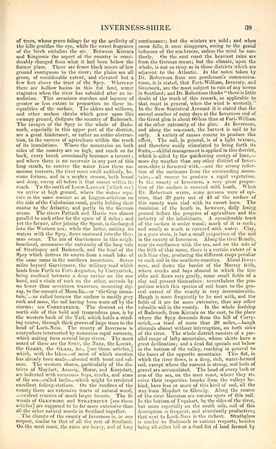
of trees, whose green foliage far up the acclivity of
the hills gratifies the eye, while the sweet fragrance
of the birch embalms the air. Between Kinrara
and Kingussie the aspect of the country is consi-
derably changed from what it had been below the
former place. There are fewer black moors of low
ground contiguous to the river; the plains are all
green, of considerable extent, and elevated but a
few feet above the tract of the Spey. Wherever
there are hollow basins in this flat land, water
stagnates when the river has subsided after an in-
undation. This occasions marshes and lagoons of
greater or less extent in proportion to these in-
equalities of the surface. The alders and willows,
and other useless shrubs which grow upon this
swampy ground, disfigure the country of Badenoch.
The ravages of the Spey in the whole of Bade-
noch, especially in this upper part of the district,
are a great hinderance, or rather an entire obstruc-
tion, to the success of agriculture within the reach
of its inundations. "Where the mountains on both
sides of the country are so high, and reach so far
back, every brook occasionally becomes a torrent ;
and where there is no reservoir in any part of this
long strath, to receive the water from these nu-
merous torrents, the river must swell suddenlv, be-
come furious, and in a mighty stream, both broad
and deep, sweep all before it that comes within its
reach. To the north of Loch-Laggan [which see]
we arrive at high ground, where the waters sepa-
rate in the same manner as at Laggan-achdrom on
the side of the Caledonian canal, partly holding their
course to the Atlantic, and partly to the German
ocean. The rivers Pattack and Massie run almost,
parallel to each other for the space of 2 miles ; and
yet the former, after joining the Spean, is discharged
into the Western sea; while the latter, uniting its
waters with the Spey, flows eastward into the Ger-
man ocean. The inn of Garviemore in this neigh-
bourhood, announces the extremity of the long vale
of Strathspey and Badenoch, and the head of the
Spey which derives its source from a small lake of
the same name in the northern mountains. Seven
miles beyond Garviemore, the military road which
leads from Perth to Fort-Augustus, by Corryarrick,
being confined between a deep ravine on the one
hand, and a chain of rock on the other, ascends by
no fewer than seventeen traverses, mounting zig-
zag, to the summit of Mona-lia — or ' the Gray moun-
tain,' — so called because the surface is mostly grey
rock and moss, the soil having been worn off by the
storms: see Corryarrick. The descent on the
north side of this bold and tremendous pass, is by
the western bank of the Tarf, which holds a wind-
ing course, through thick groves of large trees to the
head of Loch-Ness. The county of Inverness is
everywhere intersected by numerous rapid currents,
which uniting form several large rivers. The most
noted of these are the Spey, the Ness, the Lochy,
the Garry, the Glass, &c, [see these articles,]
which, with the lakes — of most of which mention
has already been made — abound with trout and sal-
mon. The western shores, particularly of the dis-
tricts of Moydart, Arasaig, Morar, and Knoydart,
are indented with numerous bays, creeks, and arms
of the sea — called lochs — which might be rendered
excellent fishing-stations. On the confines of the
county there are extensive tracts of natural wood,
— evident remains of much larger forests. The fir
woods of Glenjiore and Strathspey [see these
articles] are supposed to be far more extensive than
all the other natural woods in Scotland together.
The climate of the county of Inverness is, in one
respect, similar to that of all the rest of Scotland.
On the west coast, the rains are heavy, and of long
continuance; but the winters are mild; and when
snow falls, it soon disappears, owing to the genial
influence of the sea-breeze, unless the wind be nor-
therly. On the east coast the heaviest rains are
from the German ocean; but the climate, upon the
whole, is not so rainy as in those districts which are
adjacent to the Atlantic. In the notes taken by
Dr. Robertson from one gentlemen's communica-
tions, it is stated, that Fort- William, Inverary, and
Greenock, are the most subject to rain of any towns
in Scotland; and Dr. Robertson thinks "there is little
doubt of the truth of this remark, as applicable to
that coast in general, when the wind is westerly."
In the New Statistical Account it is stated that the
annual number of rainy days at the Inverness end of
the Great glen is about 60 less than at Fort- William
at the other extremity of the glen. At Inverness,
and along the sea-coast, the harvest is said to be
early. A variety of causes concur to produce this
effect. The soil, in general, is of a light texture,
and therefore easily stimulated to bring forth its
fruits,. — skilful management is applied in this district,
which is aided by the quickening energy of lime, —
more dry weather than any other district of Inver-
ness-shire is favoured with, — and the strong reflec-
tion of the sunbeams from the surrounding moun-
tains, — all concur to produce a rapid vegetation.
In the county of Inverness, a very great propor-
tion of the surface is covered with heath. "When
Dr. Robertson wrote, some persons were of opi-
nion, that 39 parts out of 40 of the surface of
this county were clad with its russet hues. The
dominion of the heath is, however, daily losing
ground before the progress of agriculture and the
industry of the inhabitants. A considerable tract
of the surface is under wood; much of it is rock;
and nearly as much is covered with water. Clay,
in a pure state, is but a small proportion of the soil
in the county of Inverness. Along the river Beauly,
near its confluence with the sea, and on the side of
the frith of that name, there is a certain extent of a
rich blue clay, producing the different crops peculiar
to such soil in the southern counties. About Inver-
ness, and down the border of the Murray frith,
where creeks and bays abound in which the tide
ebbs and flows very gently, some small fields of a
clay soil present themselves: nevertheless the pro-
portion which this species of soil bears to the gen-
eral extent of the county is very inconsiderable.
Haugh is more frequently to be met with, and the
fields of it are far more extensive, than any other
valuable soil in the county. In the whole lordship
of Badenoch, from Kinrara on the east, to the place
where the Spey descends from the hill of Corry-
arrick, — a tract of more than 20 miles, — haugh
abounds almost without interruption, on both sides
of the river. The whole district consists of a par-
allel range of lofty mountains, whose skirts have a
great declination ; and a dead flat spreads out below
in the bottom of the valley, reaching in general to
the bases of the opposite mountains. This flat, in
which the river flows, is a deep, rich, water-formed
soil, except where the current is strong, and beds of
gravel are accumulated. The head of every loch or
arm of the sea, on the west coast, where they re-
ceive their respective brooks from the valleys be-
hind, have less or more of this kind of soil, all the
way from Moydart to Glenelg. Along the course
of the river Moriston are various spots of this soil.
In the bottom of Urquhart, by the sides of the river,
but more especially on the south side, soil of this
description is frequent, and abundantly productive ;
that next to Loch-Ness is the richest. Strathglass
is similar to Badenoch in various respects, besides
being all either hill or a dead flat of land formed by
Set display mode to: Large image | Transcription
Images and transcriptions on this page, including medium image downloads, may be used under the Creative Commons Attribution 4.0 International Licence unless otherwise stated. ![]()
| Gazetteers of Scotland, 1803-1901 > Topographical, statistical, and historical gazetteer of Scotland > Volume 2 > (49) Page 39 - INV |
|---|
| Permanent URL | https://digital.nls.uk/97449178 |
|---|
| Description | Volume second: I-Z. |
|---|---|
| Shelfmark | Map Room Ref.2 |
| Attribution and copyright: |
|

