Gazetteer of Scotland
(85) Page 83 - DUM
Download files
Complete book:
Individual page:
Thumbnail gallery: Grid view | List view

1) U M
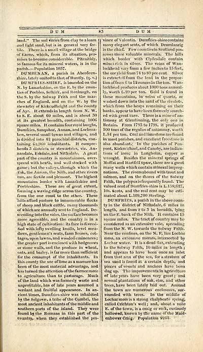
land." The soil Varies from clay to a loam
ami light sand, hut is in general very fer-
tile. There is a small village at the bridge
of Earne, which, from its situation, pro-
mises to become considerable. Pitcaithly,
30 famous for its mineral waters, is in the
parish.— Population 1037.
' DOMBENAN, a parish in Aberdeen-
shire, lately united to that of Huntly. (q. v.)
DUMFRIES-SHIRE, is bounded on the
N. by Lanarkshire, on the E. by the coun-
ties of Peebles, Selkirk, and Roxburgh, on
the S. by the Solway Frith and the mar-
ches of England, and on the W. by the
stewartry of Kirkcudbright and the county
of Ayr. It extends in length from N. W.
to S. E. about 60 miles, and is about 30
at its greatest breadth, containing 100G
square miles. It contains four royal burghs,
Dumfries, Sanquhar, Annan, and Lochma-
ben, several small towns and villages, and
is divided into 42 parochial districts, con-
taining 62,960 inhabitants. It compre-
hends 3 districts or stewartries, viz. An-
nandale, Eskdale.and Nithsdale. A great
part of the country is mountainous, over-
spread with heath, and well stocked with
game; but the valleys, through which the
Esk, the Annan, the Nith, and other rivers
run, are fertile and pleasant. The highest
mountains border with Lanarkshire and
Peebleshire. These are of great extent,
forming a waving ridge across the countiy,
from the one coast to the other. These
"hills afford pasture to innumerable flocks
of sheep and black cattle, many thousands
of Which are annually sentto England. De-
scending into the vales, the surfacebecomes
more agreeable, and the country is in a
high state of cultivation : its face is diversi-
fied with lofty swelling knolls, level mea-
dows, gentlemen's seats, farm houses, cot-
tages, open lawns, and wooded eminences ;
the greater part is enclosed with hedgerows
or stone walls, and the produce in wheat,
oats, and barley, is farmore than sufficient
for the consumpt of the inhabitants. In
this county the use of lime as a manure has
been of the most material advantage, and
has turned the attention of the farmer more
to agriculture than to pasturage. Much
of the land which was formerly waste and
unprofitable, has of late years assumed a
verdant and fruitful appearance. In an-
cient times, Dumfries-shire was inhabited
by the Selgovae, a tribe of the Cumbri, the
most ancient inhabitants of the middle and
southern parts of the island. They were
found by the Romans in this part of the
country, when they established the pro-
; D U M
vince of Valentia. Dumfries-shirecontains
many elegant seats, of which Drumlanrig
is the chief. Few countiejin Scotland pos-
sesses more valuable minerals. The hills
which border with Clydesdale contain
mines rich in silver. The veins of Wan-
lockhead vary from a few inches to 15 feet,
the ore yield from 74 to 80 per cent . Silver
is extracted' from the lead in the propor-
tion offro-.n C tol2ouncesintheton. Wan-
lockhead produces about 1000 tons annual-
ly, worth L.20 per ton. Gold is found in
these mountains, in veins of quartz, or
washed down into the sand of the rivulets,
which from the heaps remaining on their
banks, appear to have been formerly search-
ed with great care. There is a mine of an-
timony at Glendinning, the only one in
Britain, From 1793 to 179S, it produced
100 tons of the regulus of antimony, worth
L.S4 per ton. Coal and limestone are found
in most parishes, and excellent freestone is
also abundant.^ In the parishes of Pen-
pont, Kirkmichael, and Canoby, are indica-
tions of iron; in Langholm, copper is
wrought. Besides the mineral springs of
Moffat and Hartfell Spaw, there are a great
many wells which contain mineral impreg-
nations. The rivers abound with trout and
salmon, and on the snores of the Solway
Frith, the polypus is frequently found. The
valued rent of Dumfries-shire is L.15S;627,
10s. Scots, and the real rent may be esti-
mated about L. 109,700 Sterling.
DUMFRIES, a parish in the above coun-
ty in the district of Nithsdale, 6 miles in
length, and from 2 to 3 in breadth, lying
on the E. bank of the Nith. It contains 15
square miles. The tract of country may be
considered as an extensive vale, spreading
from the N. W. towards the Solway Frith.
Near the confines, on the N. E. lies Lochar
moss, an extensive morass, intersected by
Lochar water. It is a dead flat, extending
to the Solway Frith, 10 miles in length ;
and appears to have been once an inlet
from that arm of the sea, for a stratum of
sea sand is found at a certain depth, and
pieces of vessels and anchors have been
dug up. The improvements in agriculture
of late years have been very great ; and
several plantations of oak, elm, and other
trees, have been lately laid out. Around
the town are numerous enclosures, sur-
rounded with trees. In the middle of
Lochar moss is a strong chalybeate spring,
called Crichton's well ; and, about a mile
E. of the town, is a craig or rock, curiously
hollowed, known by the name of the Maid»
enbbwer Craig. Population 9262.
Set display mode to: Large image | Transcription
Images and transcriptions on this page, including medium image downloads, may be used under the Creative Commons Attribution 4.0 International Licence unless otherwise stated. ![]()
| Gazetteers of Scotland, 1803-1901 > Gazetteer of Scotland > (85) Page 83 - DUM |
|---|
| Permanent URL | https://digital.nls.uk/97422714 |
|---|

