Gazetteer of Scotland
(56) Page 54
Download files
Complete book:
Individual page:
Thumbnail gallery: Grid view | List view

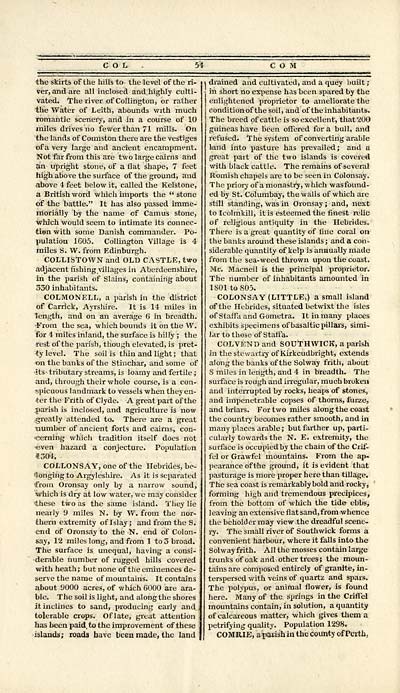
COL
the skirts of the hills to the level of the ri-
ver, and are all inclosed and highly culti-
vated. The river of Collingtou, or rather
the Water of Leith, abounds with much
romantic scenery, and in a course of 10
miles drives no fewer than 71 mills. On
the lands of Comiston there are the vestiges
of a very large and ancient encampment.
Not far from this are two large cairns and
an upright stone, of a flat shape, 7 feet
high above the surface of the ground, and
above 4 feet below it, called the Kelstone,
a British word which imports the " stone
of the battle." It has also passed imme-
morially by the name of Camus stone,
■which would seem to intimate its connec-
tien with some Danish commander. Po-
pulation 1605. Collington Village is 4
miles S. W. from Edinburgh.
COLLISTOWN and OLD CASTLE, two
adjacent fishing villages in Aberdeenshire,
in the parish of Slains, containing about
330 inhabitants.
COLMONELL, a parish in the district
of Carrick, Ayrshire. It is 14 miles in
length, and on an average 6 in breadth.
•From the sea, which bounds it on the W.
for 4 miles inland, the surface is hilly ; the
rest of the parish, though elevated, is pret-
ty level. The soil is thin and light; that
on the banks of the Stinchar, and some of
its- tributary streams, is loamy and fertile ;
and, through their whole course, is a con-
spicuous landmark to vessels when they en-
ter the Frith of Clyde. A great part of the
parish is inclosed, and agriculture is now
greatly attended to. There are a great
tiumber of ancient forts and cairns, con-
'cerning which tradition itself does not
•even hazard a conjecture. Population
*304.
COLLONS AY, one of the Hebrides, be-
longing to Argyleshire. As it is separated
■from Oronsay only by a narrow sound,
which is dry at low water, we may consider
these two as the same island. They lie
nearly 9 miles N. by W. from the nor-
thern extremity of Islay ; and from the S.
end of Oronsay to the N. end of Colon-
say, 12 miles long, and from 1 to 3 broad.
The surface is unequal, having a consi-
derable number of rugged hills covered
with heath; but none of the eminences de-
serve the name of mountains. It contains
about 9000 acres, of which 6000 are ara-
ble. The soil is light, and along the shores
it inclines to sand, producing early and
tolerable crops. Oflate, great attention
has been paid, to the improvement of these
islands; roads have been made, the land
54 COM
i drained and cultivated, and a quey built ;
in short no expense has been spared by the
enlightened proprietor to ameliorate the
conditionof the soil, and of the inhabitants.
The breed of cattle is so excellent, that 200
guineas have been offered for a bull, and
refused. The system of converting arable
land into pasture has prevailed; and a
great part of the two islands is covered
with black cattle. The remains of several
Romish chapels are to be seen in Colonsay.
The priory of a monastry, w hich wasfound-
ed by St. Columbay, the walls of which arc
still standing, was in Oronsay ; and, next
to Icolmkill, it is esteemed the finest relic
of religious antiquity in the Hebrides.
There is a great quantity of fine coral on
the banks around these islands ; and a con -
siderable quantity of kelp is annually made
from the sea-weed thrown upon the coast.
M-r. Macneil is the principal proprietor.
The number of inhabitants amounted in
lS01to805.
COLONSAY (LITTLE,) a small island
of the Hebrides, situated betwixt the isles
of Staff "a and Gometra. It in many places
exhibits specimens of basaltic pillars, simi-
lar to those of Staffa.
COL VEND and SOUTHWICK, a parish
in the stewartry of Kirkcudbright, extends
along the banks of the Solway frith, about
S miles in length, and 4 in breadth. The
surface is rough and irregular, much broken
and interrupted by rocks, heaps of stones,
and impenetrable copses of thorns, furae,
and briars. For two miles along the coast
the country becomes rather smooth, and in
many places arable ; but farther up, parti-
cularly towards the N. E. extremity, the
surface is occupied by the chain of the Crif-
fel or Grawfel mountains. From the ap-
pearance of the ground, it is evident that
pasturage is more proper here than tillage.
The sea coast is remarkably bold and rocky,
forming high and tremendous precipices,
from the bottom of which the tide ebbs,
leaving an extensive flat sand,from whence
the beholder may view the dreadful scene-
ry. The small river of Southwick forms a
convenient harbour, where it falls into the
Solway frith. All the mosses contain large
trunks of oak and other trees ; the moun-
tains are composed entirely of granite, in-
terspersed with veins of quartz and spars.
The polypus, or animal flower, is found
here. Many of the springs in the CrifTel
mountains contain, in solution, a quantity
of calcareous matter, which gives them a
petrifying quality. Population 1298.
COMRIE, a parish in the county of Perth,
Set display mode to: Large image | Transcription
Images and transcriptions on this page, including medium image downloads, may be used under the Creative Commons Attribution 4.0 International Licence unless otherwise stated. ![]()
| Gazetteers of Scotland, 1803-1901 > Gazetteer of Scotland > (56) Page 54 |
|---|
| Permanent URL | https://digital.nls.uk/97422366 |
|---|

