Gazetteer of Scotland
(54) Page 52
Download files
Complete book:
Individual page:
Thumbnail gallery: Grid view | List view

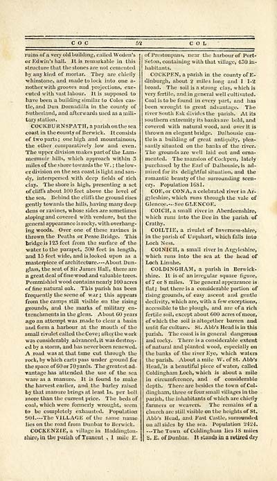
c o c
ruins of a very old building, culled Woden's
or Edwin's hall. It is remarkable in this
structure that the stones are not cemented
by any kind of mortar. They are chiefly
•whinstone, and made to lock into one a-
nother with grooves and projections, exe-
cuted with vast labour. It is supposed to
have been a building similar to Coles cas-
tle, and Dun Dornadilla in the county of
Sutherland, and afterwards used as a mili-
tary station.
COCKBURNSPATH, a parish on the sea
coast in the county of Berwick. It consists
of two parts ; one high and mountainous,
the other comparatively low and even.
The upper division makes part of the Lam-
mermuir hills, which approach within 3
miles of the shore towards the W. ; the low-
er division on the sea coast is light and san-
dy, interspersed with deep fields of rich
clay. The shore is high, presenting a set
of cliffs about 100 feet above the level of
the sea. Behind the cliffs the ground rises
gently towards the hills, having many deep
dens or ravines, whose sides are sometimes
sLoping and covered with verdure, but the
general appearance is rocky, with overhang-
ing woods. Over one of these ravines is
thrown the Peaths or Pease Bridge. This
bridge is 123 feet from the surface of the
water to the parapet, 300 feet in length,
and 15 feet wide, and is.looked upon as a
masterpiece of architecture.— About Dun-
glass, the seat of Sir James Hall, there are
a great deal of fine wood and valuable trees.
Pemmishiel wood contains nearly 100 acres
of fine natural oak. This parish has been
frequently the scene of war ; this appears
from the camps still visible on the rising
grounds, and the marks of military en-
trenchments in the glens. About 60 years
ago an attempt was made to clear a basin
and form a harbour at the mouth of the
small rivulet called the Cove ; aft or the work
was considerably advanced, it was destroy-
ed by a storm, and has never been renewed.
A road was at that time cut through the
rock, by which carts pass under ground for
the space of 60 or 70 yards. The greatest ad-
Tantage has attended the use of the sea
■ware as a manure. It is found to make
the harvest earlier, and the barley raised
by that manure brings at least Is. per boll
more than the current price. The beds of
coal, which were formerly wrought, seem
to be completely exhausted. Population
904.— The VILLAGE of the same name
lies on the road from Dunbar to Berwick.
COCKENZIE, a village in Haddington-
shire, ia the parish of Tranent , 1 mile E.
52 COL
of Prestonpans, near the harbour of Port-
Seton, containing with that village, 430 in-
habitants.
COCKPEN, a parish in the county of E-
dinburgh, about 2 miles long and 1 1-2
broad. The soil is a strong clay, which is
very fertile, and in general well cultivated.
Coal is to be found in every part, and has
been wrought to great advantage. The
river South Esk divides the parish. At its
southern extremity its banks are bold, and
covered with natural wood, and over it is
thrown an elegant bridge. Dalhousie cas-
tle is a building of great antiquity, plea-
santly situated on the banks of the river.
The grounds are well laid out and orna-
mented. The mansion of Cockpeu, lately
purchased by the Earl of Dalhousie, is ad-
mired for its delightful situation, and the
romantic beauty of the surrounding scen-
ery. Population 1681.
COE.or CON A, a celebrated river in Ar-
gyleshire, which runs through the vale of
Glencoe.— See GLENCOE.
COICH, a small river in Aberdeenshire,
which runs into the Dee in the parish of
Crathy.
COILTIE, a rivulet of Inverness-shire,
in the parish of Urquhart, which falls into
Loch Ness.
COINICII, a small river in Argyleshire,
which runs into the sea at the head of
Loch Linnhe.
COLDINGHAM, a parish in Berwick-
shire. It is of an irregular square figure,
of 7 or 8 miles. The general appearance is
flat; but there is a considerable portion of
rising grounds, of easy ascent and gentle
declivity, which are, with a few exceptions,
accessible to the plough, and are of a rich
fertile soil, except about 600 acres of moor,
of which the soil is altogether barren and
unfit for culture. St. Abb's Head is in this
parish. The coast is in general dangerous
and rocky. There is a considerable extent
of natural and planted wood, especially on
the banks of the river Eye, which waters
the parish. About a mile W. of St. Abb's
Head, 'is a beautiful piece of water, called
Coldingham Loch, which is about a mile
in circumference, and of considerable
depth. There are besides the town of Col-
dingham, three or four small villages in the
parish, the inhabitants of which are chiefly
farmers or weavers. The remains of a
church are still visible on the heights of St.
Abb's Head, and Fast Castle, surrounded
on all sides by the sea. Population 2424.
—The Town of Coldingham lie3 IS miles
S. E. of Dunbar. It stands in a retired dry
Set display mode to: Large image | Transcription
Images and transcriptions on this page, including medium image downloads, may be used under the Creative Commons Attribution 4.0 International Licence unless otherwise stated. ![]()
| Gazetteers of Scotland, 1803-1901 > Gazetteer of Scotland > (54) Page 52 |
|---|
| Permanent URL | https://digital.nls.uk/97422342 |
|---|

