Ordnance gazetteer of Scotland
(1497) Page 1489
Download files
Complete book:
Individual page:
Thumbnail gallery: Grid view | List view
SLAINS CASTLE
N by W of Collieston, was built in 1828, and belongs to
Alexander Gordon- Cumming-Skene, Esq. of Pakkhill.
Slains is in the presbytery of Ellon and the synod of
Aberdeen; the living is worth £248. The parish church,
I mile N by E of Collieston, was built in 1806, and
contains 654 sittings. It was thoroughly repaired and
renovated in 1882; and a new manse was built in 1876.
There is also a Free church; and three schools — Collie-
ston public, Slains public, and the Bruce-Hay girls'
public — with respective accommodation lor 74, 100, and
72 children, have an average attendance of about 50,
60, and 70, and grants amounting to nearly £45, £60,
and £60. Pop. (1801) 970, (1831) 1134, (1861) 1266,
(1871) 1355, (1881) 1256, (1891) 1279, of whom 419 were
in Collieston.— Ord. Sur., shs. 87, 77, 1876-73.
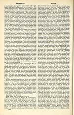
Slains Castle, the seat of the Earl of Erroll, in
Cruden parish, Aberdeenshire, on the brink of a lofty
sea-cliff, 1J mile SSW of the Bullers of Buchan, 5
miles NNE of Old Slains Castle, and 7 SSW of Peter-
head. Built in 1664, and much extended at several
periods, it was, with exception of the lower part of its
original tower and of two other small portions, rebuilt
in 1836-37; and now is a stately and commodious edifice.
Dr Johnson, who was here in 1773, described it as
' built upon the margin of the sea so that the walls
of one of the towers seem only a continuation of a
perpendicular rock, the foot of which is beaten by the
waves. To walk round the house seemed (and is)
impracticable. From the windows the eye wanders
over the sea that separates Scotland from Norway, and,
when the winds beat with violence, must enjoy all the
terrific grandeur of the tempestuous ocean. I would
not, for my amusement, wish for a storm ; but as
storms, whether wished for or not, will happen, I
may say, without violation of humanity, that I should
willingly look out upon them from Slains Castle. ' In
1894 a vessel was wrecked at this spot. Charles Gore
Hay, twenty-third Hereditary Lord High Constable of
Scotland since 1315, and nineteenth Earl of Erroll since
1452 (b. 1852; sue. 1891) is present proprietor. — Ord.
Sur., sh. 87, 1876. See Lttncaety and Ekrol.
Slamannan, a village and a parish of SE Stirlingshire.
The village stands near the right bank of the Avon, 5f
miles SSW of Falkirk and 5 furlongs N by W of Sla-
mannan station on the Slamannan section (1840) of the
North British railway, this being 4J miles W by S of
Blackston Junction, 9 J ENE of Coatbridge, and 17f
ENE of Glasgow. It has a post office, with money
order, savings bank, and telegraph departments, a
branch of the Bank of Scotland, one or two hotels, and
a gaswork. Pop. of village, (1861) 482, (1881) 1644,
(1891) 1812, of whom 381 were in Blinkbonny.
The parish contains also the village of Avonbridge
and the conjoint villages of Balquhatston Row and Arn-
loss Colliery, of Binniehill and Southfield, of Limerigg
and Lochside. It is bounded N by Falkirk and Muir-
avonside, SE by Torphichen in Linlithgowshire, and SW
by New Monkland in Lanarkshire. Its utmost length,
from E to W, is 6 miles; its utmost breadth, from N to
S, is 3£ miles; and its area is 7148 acres, of which 86J
are water. The river Avon or Aven winds 8 miles east-
by-northward and east-by-southward along all the Fal-
kirk and Muiravonside boundary ; and Polness or
Drumtassie Burn runs 4| miles north-eastward along
nearly all the Torphichen boundary, till it falls into the
Avon at the eastern extremity of the parish. Tri-
angular Black Loch ( & x J mile) lies just on the New
Monkland border; and 5 furlongs ENE is Little Black
Loch (If x 1 furl. ) The surface is flatfish, sinking along
the Avon to a little less than 500 feet above sea-level, and
attaining a summit altitude of 707 feet near the Little
Black Loch. The lands adjacent to the Avon, to the
breadth of about a mile, comprise haugh and meadow,
and are subject to floods after heavy rains. The rocks
are mainly carboniferous, and include great quantities
of excellent coal and ironstone. The parish abounds in
collieries. Mining consequently employs a large pro-
portion of the population, and the manufacture of coke
is extensively carried on. There is also a woollen manu-
SLATE ISLANDS
factory at Avonbridge. The soil of the haugh and the
meadow lands is light and fertile; and that of the higher
tracts is partly a good loam, partly strong hard clay,
partly black mossy earth, and partly moor or wet moss
overlying a bed of sand. Much ground, formerly
heathy or swampy, has been reclaimed into good arable
condition. Part, or perhaps the whole, of the parish
was obtained in 1470 from James II. by Lord Living-
stone; and, along with the advowson of the church, was
held by his lordship's successors, the Earls of Linlithgow
and Calendar, till their attainder in 1716. The parish
in pre-Reformation times was called St Laurence — on
account of the dedication of its church to this saint;
and, in legal instruments, it is still designated 'the
parish of Slamannan, otherwise St Laurence.' An
excellent fountain, a little SE of the church, bears the
name of St Laurence's Well. A mansion, noticed separ-
ately, is Balquhatston. Since 1730 the southern
portion of Falkirk parish has been annexed ecclesiastic-
ally to Slamannan, which is in the presbytery of Lin-
lithgow and the synod of Lothian and Tweeddale. The
living is worth £308. The parish church was built in
1810, and contains some 700 sittings. In 1892 it was
improved interiorly. A mission church (iron) was
opened at Limerigg in 1886. There are also Free and
Methodist churches, besides an Evangelical Union
church at Avonbridge, and a Roman Catholic church
(St Mary's) at Slamannan (1885) with 300 sittings.
Four schools — Avonbridge public, Limerigg public,
Rosemount public, and Slamannan public — with respec-
tive accommodation for 150, 332, 146, and 613 children
— have an average attendance of about 125, 290, 145,
and 560, and grants amounting to nearly £125, £295,
£140, and £555. There is a Roman Catholic school at
Barnsmuir, with accommodation for 132 children, an
average attendance of about 80, and a grant of nearly
£60. Pop. of civil parish (1871) 4164, (1881) 5850,
(1891) 6731; of ecclesiastical parish (1871) 4847, (1881)
6428, (1891) 7221.— Ord. Sur., sh. 31, 1867.
Slapin, a sea-loch on the S side of Strath parish, Isle
of Skye, Inverness-shire, striking at right angles from
the mouth of Loch Eishort, and penetrating 4J miles
north-by-westward to within 3 miles of the head of
Loch Eynort, on the opposite side of the island. Across
the entrance it measures 2i miles, and thence narrows
gradually to a point. It goes parallel with Loch Scavaig,
and, in common with that sea-loch, is sublimely over-
hung by Blabhein or Blaven (3042 feet).
Slate. See Sleat.
Slateford, a village in Colinton and St Cuthberts
parishes, Edinburghshire, on the Water of Leith and
the Union Canal, £ mile SSW of Slateford station on
the Caledonian railway, this being 2J miles SW of the
Edinburgh terminus. It has a post office, with money
order, savings bank, and telegraph departments, a
bridge, a canal aqueduct, a railway viaduct, the parish
church (rebuilt 1889-90), an old U.P. church, a public
school, a police station, and the extensive bleachfield
of Inglis Green. The Rev. John Dick, D.D. (1764-
1833), afterwards professor of theology to the Associate
Synod, was minister here from 1786 to 1803; and
Robert Pollok (1799-1827), author of the Course of
Time, spent the last summer of his life with Dr Dick's
successor, the Rev. John Belfrage, M.D., and preached
once or twice in his church. The aqueduct and the
viaduct are magnificent works, the former 500 feet long
and 65 high; and they and the bridge stand so near one
another, and have such different heights, as to form a
curious scene. Pop. (1841) 221, (1861) 514, (1871) 647,
(1881) 621, (1891) 622, of whom 521 were in Colinton
parish.— Ord. Sur., sh. 32, 1857.
Slateford, a small village in Maybole parish, Ayr-
shire, 1£ mile N by E of the town.
Slateford, Forfarshire. See Edzell.
Slate Islands, a group of islands off the mainland of
Lorn district, Argyllshire. It commences 7£ miles
SSW of Oban, and terminates 4J miles N by W of
Craignish Point; measures about 10 miles in length
from N to S, and about 3i miles in breadth ; is separated
1489
N by W of Collieston, was built in 1828, and belongs to
Alexander Gordon- Cumming-Skene, Esq. of Pakkhill.
Slains is in the presbytery of Ellon and the synod of
Aberdeen; the living is worth £248. The parish church,
I mile N by E of Collieston, was built in 1806, and
contains 654 sittings. It was thoroughly repaired and
renovated in 1882; and a new manse was built in 1876.
There is also a Free church; and three schools — Collie-
ston public, Slains public, and the Bruce-Hay girls'
public — with respective accommodation lor 74, 100, and
72 children, have an average attendance of about 50,
60, and 70, and grants amounting to nearly £45, £60,
and £60. Pop. (1801) 970, (1831) 1134, (1861) 1266,
(1871) 1355, (1881) 1256, (1891) 1279, of whom 419 were
in Collieston.— Ord. Sur., shs. 87, 77, 1876-73.
Slains Castle, the seat of the Earl of Erroll, in
Cruden parish, Aberdeenshire, on the brink of a lofty
sea-cliff, 1J mile SSW of the Bullers of Buchan, 5
miles NNE of Old Slains Castle, and 7 SSW of Peter-
head. Built in 1664, and much extended at several
periods, it was, with exception of the lower part of its
original tower and of two other small portions, rebuilt
in 1836-37; and now is a stately and commodious edifice.
Dr Johnson, who was here in 1773, described it as
' built upon the margin of the sea so that the walls
of one of the towers seem only a continuation of a
perpendicular rock, the foot of which is beaten by the
waves. To walk round the house seemed (and is)
impracticable. From the windows the eye wanders
over the sea that separates Scotland from Norway, and,
when the winds beat with violence, must enjoy all the
terrific grandeur of the tempestuous ocean. I would
not, for my amusement, wish for a storm ; but as
storms, whether wished for or not, will happen, I
may say, without violation of humanity, that I should
willingly look out upon them from Slains Castle. ' In
1894 a vessel was wrecked at this spot. Charles Gore
Hay, twenty-third Hereditary Lord High Constable of
Scotland since 1315, and nineteenth Earl of Erroll since
1452 (b. 1852; sue. 1891) is present proprietor. — Ord.
Sur., sh. 87, 1876. See Lttncaety and Ekrol.
Slamannan, a village and a parish of SE Stirlingshire.
The village stands near the right bank of the Avon, 5f
miles SSW of Falkirk and 5 furlongs N by W of Sla-
mannan station on the Slamannan section (1840) of the
North British railway, this being 4J miles W by S of
Blackston Junction, 9 J ENE of Coatbridge, and 17f
ENE of Glasgow. It has a post office, with money
order, savings bank, and telegraph departments, a
branch of the Bank of Scotland, one or two hotels, and
a gaswork. Pop. of village, (1861) 482, (1881) 1644,
(1891) 1812, of whom 381 were in Blinkbonny.
The parish contains also the village of Avonbridge
and the conjoint villages of Balquhatston Row and Arn-
loss Colliery, of Binniehill and Southfield, of Limerigg
and Lochside. It is bounded N by Falkirk and Muir-
avonside, SE by Torphichen in Linlithgowshire, and SW
by New Monkland in Lanarkshire. Its utmost length,
from E to W, is 6 miles; its utmost breadth, from N to
S, is 3£ miles; and its area is 7148 acres, of which 86J
are water. The river Avon or Aven winds 8 miles east-
by-northward and east-by-southward along all the Fal-
kirk and Muiravonside boundary ; and Polness or
Drumtassie Burn runs 4| miles north-eastward along
nearly all the Torphichen boundary, till it falls into the
Avon at the eastern extremity of the parish. Tri-
angular Black Loch ( & x J mile) lies just on the New
Monkland border; and 5 furlongs ENE is Little Black
Loch (If x 1 furl. ) The surface is flatfish, sinking along
the Avon to a little less than 500 feet above sea-level, and
attaining a summit altitude of 707 feet near the Little
Black Loch. The lands adjacent to the Avon, to the
breadth of about a mile, comprise haugh and meadow,
and are subject to floods after heavy rains. The rocks
are mainly carboniferous, and include great quantities
of excellent coal and ironstone. The parish abounds in
collieries. Mining consequently employs a large pro-
portion of the population, and the manufacture of coke
is extensively carried on. There is also a woollen manu-
SLATE ISLANDS
factory at Avonbridge. The soil of the haugh and the
meadow lands is light and fertile; and that of the higher
tracts is partly a good loam, partly strong hard clay,
partly black mossy earth, and partly moor or wet moss
overlying a bed of sand. Much ground, formerly
heathy or swampy, has been reclaimed into good arable
condition. Part, or perhaps the whole, of the parish
was obtained in 1470 from James II. by Lord Living-
stone; and, along with the advowson of the church, was
held by his lordship's successors, the Earls of Linlithgow
and Calendar, till their attainder in 1716. The parish
in pre-Reformation times was called St Laurence — on
account of the dedication of its church to this saint;
and, in legal instruments, it is still designated 'the
parish of Slamannan, otherwise St Laurence.' An
excellent fountain, a little SE of the church, bears the
name of St Laurence's Well. A mansion, noticed separ-
ately, is Balquhatston. Since 1730 the southern
portion of Falkirk parish has been annexed ecclesiastic-
ally to Slamannan, which is in the presbytery of Lin-
lithgow and the synod of Lothian and Tweeddale. The
living is worth £308. The parish church was built in
1810, and contains some 700 sittings. In 1892 it was
improved interiorly. A mission church (iron) was
opened at Limerigg in 1886. There are also Free and
Methodist churches, besides an Evangelical Union
church at Avonbridge, and a Roman Catholic church
(St Mary's) at Slamannan (1885) with 300 sittings.
Four schools — Avonbridge public, Limerigg public,
Rosemount public, and Slamannan public — with respec-
tive accommodation for 150, 332, 146, and 613 children
— have an average attendance of about 125, 290, 145,
and 560, and grants amounting to nearly £125, £295,
£140, and £555. There is a Roman Catholic school at
Barnsmuir, with accommodation for 132 children, an
average attendance of about 80, and a grant of nearly
£60. Pop. of civil parish (1871) 4164, (1881) 5850,
(1891) 6731; of ecclesiastical parish (1871) 4847, (1881)
6428, (1891) 7221.— Ord. Sur., sh. 31, 1867.
Slapin, a sea-loch on the S side of Strath parish, Isle
of Skye, Inverness-shire, striking at right angles from
the mouth of Loch Eishort, and penetrating 4J miles
north-by-westward to within 3 miles of the head of
Loch Eynort, on the opposite side of the island. Across
the entrance it measures 2i miles, and thence narrows
gradually to a point. It goes parallel with Loch Scavaig,
and, in common with that sea-loch, is sublimely over-
hung by Blabhein or Blaven (3042 feet).
Slate. See Sleat.
Slateford, a village in Colinton and St Cuthberts
parishes, Edinburghshire, on the Water of Leith and
the Union Canal, £ mile SSW of Slateford station on
the Caledonian railway, this being 2J miles SW of the
Edinburgh terminus. It has a post office, with money
order, savings bank, and telegraph departments, a
bridge, a canal aqueduct, a railway viaduct, the parish
church (rebuilt 1889-90), an old U.P. church, a public
school, a police station, and the extensive bleachfield
of Inglis Green. The Rev. John Dick, D.D. (1764-
1833), afterwards professor of theology to the Associate
Synod, was minister here from 1786 to 1803; and
Robert Pollok (1799-1827), author of the Course of
Time, spent the last summer of his life with Dr Dick's
successor, the Rev. John Belfrage, M.D., and preached
once or twice in his church. The aqueduct and the
viaduct are magnificent works, the former 500 feet long
and 65 high; and they and the bridge stand so near one
another, and have such different heights, as to form a
curious scene. Pop. (1841) 221, (1861) 514, (1871) 647,
(1881) 621, (1891) 622, of whom 521 were in Colinton
parish.— Ord. Sur., sh. 32, 1857.
Slateford, a small village in Maybole parish, Ayr-
shire, 1£ mile N by E of the town.
Slateford, Forfarshire. See Edzell.
Slate Islands, a group of islands off the mainland of
Lorn district, Argyllshire. It commences 7£ miles
SSW of Oban, and terminates 4J miles N by W of
Craignish Point; measures about 10 miles in length
from N to S, and about 3i miles in breadth ; is separated
1489
Set display mode to: Large image | Transcription
Images and transcriptions on this page, including medium image downloads, may be used under the Creative Commons Attribution 4.0 International Licence unless otherwise stated. ![]()
| Gazetteers of Scotland, 1803-1901 > Ordnance gazetteer of Scotland > (1497) Page 1489 |
|---|
| Permanent URL | https://digital.nls.uk/97411210 |
|---|
| Description | A graphic and accurate description of every place in Scotland. Edited by Francis H. Groome. New ed., with census appendix 1901. Edinburgh: T.C. and E.C. Jack, 1901. This edition contains all the printed matter of the large 6 vol. edition, the revisions made in 1895 and subsequent partial revisions. Copy lacks title page. |
|---|---|
| Shelfmark | Map.Ref.C18 |
| Additional NLS resources: | |
| Attribution and copyright: |
|
| Description | 20 volumes of the most popular descriptive gazetteers of Scotland, providing a comprehensive geographical encyclopaedia of Scotland in the 19th century. Principal places in Scotland, including towns, counties, castles, glens, antiquities and parishes, are listed alphabetically. Each entry includes detailed historical and geographical information about each place. |
|---|---|