Ordnance gazetteer of Scotland
(76) Page 68
Download files
Complete book:
Individual page:
Thumbnail gallery: Grid view | List view

ARDROSSAN
great as would have rendered them almost the finest in
Britain; but, far exceeding the estimates, they were
brought to a standstill in 1815, over £100,000 having
been then expended, and Telford and Rennie requiring
£300,000 more. They were not resumed till 1833,
when the thirteenth earl came of age, and then were
completed on a greatly reduced though still considerable
scale, the total cost being upwards of £200,000, and the
harbour comprising two tidal basins of 6 and 18 acres,
and a wet-dock of 4 acres, with 19 feet at high water
over the lock-sill. In 18S6, however, it was found
necessary to provide greater depth of water, and to
accommodate, in addition to the extensive traffic from
the Glasgow and South-Western railway, the traffic
from the Caledonian railway upon the opening, in 1888,
of the Lanarkshire and Ayrshire line to Ardrossan.
The Ardrossan Harbour Company was accordingly formed
with a capital of £300,000, Lord' Egliu ton himself taking
£200,000 worth of shares, and an additional dock (the
Eglinton) has been built, with an area of about 10 acres
and a depth of 27 feet, where the largest vessels can lie
afloat at all times. An outer tidal basin has also been
formed, about 5 acres in extent, with a depth of 18 feet
at low water and of 27 feet at high. These alterations,
with other improvements, including a wide entrance
channel and extensive quay accommodation, and the
construction of a new breakwater, 1320 feet in length,
outside the harbour, make the port capable of berthing
the largest vessels. The new dock was opened 4 April
1892. The harbour is well supplied with hydraulic and
steam hoists and cranes for loading and discharging;
whilst a lighthouse with white flashing light stands at
the N W point of the outer breakwater, and a beacon tower
on sheltering Horse Island, a low and grassy islet of some
12 acres, lying § mile to the WW. At first a sub-port
of Irvine, Ardrossan was constituted a head port in 1858,
and at the close of 1894 had on its register 62 sailing
vessels of 10,857, and 9 steamers of 8693 tons. The
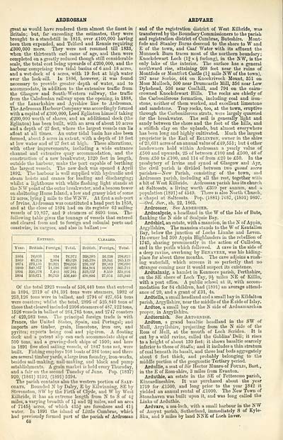
following table gives the tonnage of vessels that entered
and cleared from and to foreign and colonial ports and
coastwise, in cargoes, and also in ballast : —
Entered.
Cleaeed.
Year.
British.
Foreign.
Total.
British.
Foreign.
Total.
1864
1869
1874
1880
1891
1894
76,038
66,224
273,135
849,167
820,278
505,671
934
2,804
20,921
11,126
7,4b3
80,769
76,972 j
69,028
294,056
360,293 |
327,761
536,440
268,385
246,798
276,107
354,901
323,357
498,806
26.23S
19,341
20,583
10,822
8.559
27,034
294,623 1
265,139
296,690 j
365,723
331,916 1
525,840 !
Of the total 2923 vessels of 536,440 tons that entered
in 1894, 2319 of 494,391 tons were steamers, 1982 of
253,126 tons were in ballast, and 2794 of 427,654 tons
were coasters; whilst the total, 2895 of 525,840 tons of
those that cleared included 2306 steamers of 487, 122 tons,
1526 vessels in ballast of 264,785 tons, and 2747 coasters
of 420,083 tons. The principal foreign trade is with
France, the United States, Spain, and Portugal; and
imports are timber, grain, limestone, iron ore, and
pyrites; exports being coal and pig-iron. A floating
dock and a patent slip can each accommodate ships of
500 tons, and a graving-dock ships of 1500; and here
in 1891 five steel sailing vessels, of 1847 tons net, were
built. Fishing employs 108 boats of 386 tons; and there
are several timber yards, a largo iron foundry, iron-works,
besides sail-making, nail-making, and block and pump
establishments. A grain market is held every Thursday,
and a fair on the second Tuesday of June. Pop. (1837)
920, (1861) 3192, (1891) 5294.
The parish contains also the western portion of Salt-
coats. Bounded N by Dairy, E by Kilwinning, SE by
SteveMton, SW by the Firth of Clyde, and W by West
Kilbride, it has an extreme length from N to S of 4J
miles, a varying breadth of 1| and 2| miles, and an area
of 7145J acres, of which 435J are foreshore and 41 It
water. In 1891 the island of Little Cumbrae, which
had previously formed part of the parish ef Ardrossan
68
ARDVARE
and of the registration district of West Kilbride, was
transferred by the Boundary Commissioners to the parish
and registration district of Cumbrae, Buteshire. Mont-
fode and Stanley Burns descend to the shore to W and
E of the town, and Caaf Water with its affluent the
Munnock Burn traces most of the northern boundary ;
Knockdewart Loch (If x ^ furlong), in the NW, is the
only lake of the interior. The surface has a general
northward rise, attaining 208 feet near the ruins of
Montfode or Montfort Castle (If mile NW of the town),
287 near Sorbie, 464 on Knockrivock Mount, 351 on
Moss Mulloch, 500 near Drumcastle Mill, 356 near Low
Dykehead, 536 near Coalhill, and 794 on the cairn-
crowned Knockdewart Hills. The rocks are chiefly of
the Carboniferous formation, including coal and iron-
stone, neither of them worked, and excellent limestone
and sandstone. Trap rocks, too, at the town, eruptive
through the Carboniferous strata, were largely quarried
for the breakwater. The soil is generally light and
sandy between the shore and the foot of the hills, and
a stifflsh clay on the uplands, but almost everywhere
has been long and highly cultivated. Much the largest
proprietor is the Earl of Eglinton, owner in the shire
of 23, 631 acres of an annual value of £49, 551 ; but 4 other
landowners hold within Ardrossan a yearly value of
£500 and upwards, 25 of between £100 and £500, 46 of
from £50 to £100, and 114 of from £20 to £50. In the
presbytery of Irvine and synod of Glasgow and Ayr,
the civil parish is divided between two quoad sacra
parishes — New Parish, consisting of the town, and
Ardrossan parish, including all the rest, together with
a bit of West Kilbride. Ardrossan parish has its church
at Saltcoats, a living worth £359 per annum, and a
population (1891) of 4549. There is also North Church,
a chapel at Saltcoats. Pop. (1881) 7687, (1891) 9897.
— Orel. Sur., sh. 22, 1865.
Ardrosser. See Aedeesier.
Ardscalpsie, a headland in the W of the Isle of Bute,
flanking the N side of Scalpsie Bay.
Ardshiel, an estate, with a mansion, in the N of Appin,
Argyllshire. The mansion stands to the W of Kentallen
Bay, below the junction of Lochs Linnhe and Leven.
Its owner led 300 Appin Highlanders in the rebellion of
1745, sharing prominently in the action of Culloden,
and in the perils which followed. A cave in the side of
a deep ravine, overhung by Benaveee, was his hiding-
place for about three months. The cave adjoins a rush-
ing waterfall, which screens it so perfectly that no
stranger coming near it would suspect its existence.
Ardtalnaig, a hamlet in Kenmore parish, Perthshire,
on the SE shore of Loch Tay, 94 miles NE of Killin,
with a post office. A public school at it, with accom-
modation for 84 children, had (1891) an average attend-
ance of 20, and a grant of £31, 4s.
Ardtella, a small headland and a small bay in Kildalton
parish, Argyllshire, near the middle of the E side of Islay.
Ardtoe, a small bay on the N side of Ardnamurchan
proper, in Argyllshire.
Ardtornish. See Artoenish.
Ardtun, a grand basaltic headland in the SW of
Mull, Argyllshire, projecting from the N side of the
Ross of Mull, at the mouth of Loch Scriden. It is
cut by a wild ravine, called the Goblins' Dell; it rises
to a height of about 130 feet; it shows basaltic scarcely
inferior to those of Staila; and it includes a thin stratum
of coal beneath its basalt, and three leaf beds aggregately
about 6 feet thick, and probably belonging to the
middle portion of tho gcognostic Tertiary period.
Ardullie, a seat of Sir Hector Munro of Foulis, Bart.,
in the E of Ross-shire, 3 miles from Evanton.
Arduthie, an estate in the SE of Fetteresso parish,
Kincardineshire. It was purchased about the year
1759 for £1500, and long prior to the year J842 it
yielded an annual rental of £1000. Tho New Town of
Stonehaven was built upon it, and was long called the
Links of Arduthie.
Ardvare, a sea-loch, with a small harbour in the NW
of Assynt parish, Sutherland, immediately S of Kyle-
SUu, and 9 miles by land NNE of Loch Inver.
Set display mode to: Large image | Transcription
Images and transcriptions on this page, including medium image downloads, may be used under the Creative Commons Attribution 4.0 International Licence unless otherwise stated. ![]()
| Gazetteers of Scotland, 1803-1901 > Ordnance gazetteer of Scotland > (76) Page 68 |
|---|
| Permanent URL | https://digital.nls.uk/97394158 |
|---|

