Ordnance gazetteer of Scotland
(9) Page 1 - ANN
Download files
Complete book:
Individual page:
Thumbnail gallery: Grid view | List view

ORDNANCE GAZETTEER
OF
SCOTLAND.
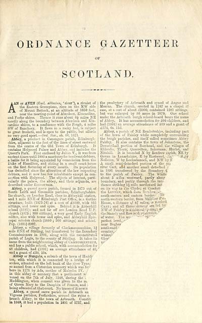
A AN or AVEN (Gael, abhuimi, 'river'), a rivulet of
A the Eastern Grampians, rises on the NW side
Jtx. °? Mount Battock, at an altitude of 1650 feet,
near the meeting-point of Aberdeen, Kincardine,
and Forfar shires. Thence it runs about 8J miles NE
mostly along the boundary between Aberdeen and Kin-
cardine shires, to a confluence with the Feugh, 4 miles
SW of Banchory. It flows in a rocky bed, is subject
to great freshets, and is open to the public, but affords
no very good sport. — Ord. Sur., sh. 66, 1871.
Abbey, a precinct in Canongate parish, Edinburgh-
shire, adjacent to the foot of the lines of street eastward
from the centre of the Old Town of Edinburgh. It
contains Holyrood Palace and Abbey, and includes the
Queen's Park. First enclosed by James V. , it was from
ancient times until 1880 a sanctuary for insolvent debtors,
a bailie for it being appointed by commission from the
Duke of Hamilton, and siltiijg in a small court-house
on the first Saturday of every month. Its population
has dwindled since the alteration of the law respecting
debtors, and it now has few inhabitants except in con-
nection with Holyrood. The objects of interest, parti-
cularly the palace, the abbey, and their adjuncts, are
described under Edinbukgh.
Abbey, a quoad sacra parish, formed in 1875 out of
South Leith and Greenside parishes, Edinburghshire.
Its church, on London Road, close to Abbeyhill station,
and 1 mile ENE of Edinburgh Post Office, is a Gothic
structure, built (1875-76) at a cost of £8000, with 855
sittings, and tower and spire. Behind it is Abbeyhill
school (1881); and not far off are London Road U.P.
church (1875 ; 950 sittings), a very good Early English
edifice, also with tower and spire, and Abbeyhill Epis-
copal mission church (1880 ; 300 sittings) and school.
Pop. (1891) 8907.
Abbey, a village formerly of Clackmannanshire, 1J
mile ENE of Stirling, but transferred by the Boundary
Commissioners in 1891, along with the reconstituted
parish of Logie, to the county of Stirling. It takes its
name from the neighbouring abbey of Cambttskenneth,
and has a public school, which, with accommodation for
48 children, had (1891) an average attendance of 40,
and a grant of £34, 13s.
Abbey or Nungate, a suburb of the town of Haddj-
ton, with which it is connected by a bridge of f
arches, situated on the left bank of the river Tyne.
so named from a Cistercian nunnery which was fo -
here in 1178 by Ada, mother of Malcolm IV.
in this abbey or nunnery that a parliament w/
vened on the 7th of July, 1548, during the\
Haddington, when consent was given to the m.
of Queen Mary to the Dauphin of France, and \
being educated at that court. No traces of it now r<
Abbey, a quoad sacra parish in Arbroath an
Vigeans parishes, Forfarshire, around the ruins o.
broath Abbey, in the town of Arbroath. Constit
in 1869, it had a population in 1891 of 5737, and
the presbytery of Arbroath and synod of Angus and
Mearns. The church, erected in 1787 as a chapel of
ease, at a cost of about £2000, contained 1281 sittings,
but was enlarged by 80 more in 1879. One school
under the Arbroath burgh school-board bears the name
of Abbey. It has accommodation for 590 children, and
had (1891) an average attendance of 589 and a grant of
£574, 6s. lid.
Abbey, a parish of NE Renfrewshire, including part
of the town of Paisley while completely surrounding
the burgh parishes, and itself called sometimes Abbey
Paisley. It also contains the town of Johnstone, the
Dovecothall portion of Barrhead, and the villages of
Elderslie, Thorn; Quarrelton, Inkerman, Hurlet, and
Nitshill. It is bounded N by Renfrew parish, NE Vy
Govan in Lanarkshire, E by Eastwood, ^.n '
Neilston, W by Lochwinnoch, and N¥ by K
A small semi-detached portion of the pa)
river Cart, and another small detached i
in 1S91 transferred by the Boundary
to the parish of Paisley. The White
about 5 iriles westward, partly alonp
boundary, and partly through the int(
thence striking 1J mile northward in!
on its way to the Clyde ; at Crooksb
the Levekn, which from BpMheai
south-eastern and eastern border' p 1 '
north-western border, from MiUi : -er/ P:"*
House, a distance .J: 4 J miles,, is marked
Cam; and all threvi stream?, are fed bv
5TW of Paisley is a mineral ■ f-ring ; sr
the Stanely and Row Dank reservoirs. '
of water. Tie no: ' ■■ ■' "'
perfect level, f
near Boghea
southward •
country,
whinn 1 "
Glen*
S.J5y
Set display mode to: Large image | Transcription
Images and transcriptions on this page, including medium image downloads, may be used under the Creative Commons Attribution 4.0 International Licence unless otherwise stated. ![]()
| Gazetteers of Scotland, 1803-1901 > Ordnance gazetteer of Scotland > (9) Page 1 - ANN |
|---|
| Permanent URL | https://digital.nls.uk/97393354 |
|---|

