Ordnance gazetteer of Scotland > Volume 3
(305) Page 235
Download files
Complete book:
Individual page:
Thumbnail gallery: Grid view | List view

HADDINGTONSHIRE
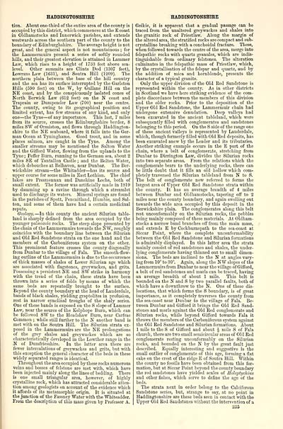
tion. About one-third of the entire area of the county is
occupied by this district, which commences at the E coast
in Oldhamstocks and Inuerwiclc parishes, and extends
westwards across the southern part of the county to tlie
boundary of Edinburglishire. The average height is not
great, and the general aspect is not mountainous ; for
the Lammermuirs present a series of softly rounded
hills, and their greatest elevation is attained in Lammer
Law, which rises to a height of 1733 feet above sea-
level. Other summits are Glints Dod (1307 feet),
Lowrans Law (1631), and Soutra Hill (1209). The
northern plain between the base of the hill country
and the sea has its surface interrupted by the Garleton
Hills (590 feet) on the ^Y, by Gullane HiU on the
NE coast, and by the conspicuously isolated cones of
North Berwick Law (612 feet) on the N coast and
Traprain or Dumpender Law (700) near the centre.
The county, owing to its geographical position and
limited extent, has few streams of any kind, and only
one — the Tyne — of any importance. This last, 7 miles
from its source, crosses the Edinburghshire border, 8
miles SW of Ormiston, and flows through Haddington-
shire to the NE seaboard, where it falls into the Ger-
man Ocean at Tyninghame. Good trout, and in some
places salmon, are caught in the Tyne. Among the
smaller streams may be mentioned the Salton Water
and the Gilford Water, flowing from the uplands to the
Tyne ; Pefler Burn, running to the German sea, about 2
miles SE of Tantallon Castle ; and the Belton Water,
which debouches at Belhaven, near Dunbar. The Ber-
wickshire stream — the Whitadder — has its source and
upper course for some miles in East Lothian. The chief
lakes are Presmeunan and Danskine Lochs, both of
small extent. The former was artificially made in 1819
by damming up a ravine through which a streamlet
used to discharge its waters. Mineral springs are found
in the parishes of Spott, Pencaitland, Humble, and Sal-
ton, and some of them have had a certain medicinal
repute.
Geology. — In this county the ancient Silurian table-
land is sharply defined from the area occupied by the
younger paljeozoic rocks. The steep slope presented by
the chain of the Lammermuirs towards the NW, roughly
coincides with the boundary line between the Silurian
and Old Red Sandstone strata on the one hand and tlie
members of the Carboniferous system on the other.
This prominent feature crosses the county diagonally
from Dunbar to the village of Fala. The smooth-flow-
ing outline of the Lammermuirs is due to the occurrence
of thick masses of shales of Lower Silurian age which
are associated with flagstones, greywackes, and grits.
Possessing a persistent NE and SW strike in harmony
with the trend of the chain, these strata have been
thrown into a series of folds by means of which the
same beds are repeatedly brought to the surface.
Beyond the county boundary at the head of Lauderdale,
bands of black shales, yielding graptolites in profusion,
rest in narrow synclinal troughs of the shaly series.
One of these bands is exposed on the S slope of Lammer
Law, near the source of the Kelphope Burn, which can
be followed SW to the Headshaw Burn, near Carfrae
Common ; whUe still further to the N another band is
met with on the Soutra Hill. The Silurian strata ex-
posed in the Lammermuirs are the NE prolongations
of the grey shales and greywackes which are so
characteristically developed in the Lowther range in the
N of Dumfriesshire. In the latter area there are
fewer intercalations of greywackes and giits, but with
this exception the general character of the beds in these
widely separated ranges is identical.
Throughout the area occupied by these rocks numerous
veins and bosses of felstone are met with, which have
been injected mainly along the lines of bedding. There
is one small triangular area, however, of highly
crystalline rock, which has attracted considerable atten-
tion among geologists on account of the evidence which
it aff'ords of its metamorphic origin. It is situated at
the junction of the Fassney Water with the Whiteadder.
From the description of this mass given by Professor A.
HADDINGTONSHIRE
Geikie, it is apparent that a gradual passage can be
traced from the unaltered greywackes and shales into
the granitic rock of Priestlaw. Along the margin of
the altered area, the stratified rocks are compact and sub-
crystalline breaking with a conchoidal fracture. These,
when followed towards the centre of the area, merge into
felspathic rocks with quartz granules, which are indis-
tinguishable from ordinary felstones. The alteration
culminates in the felspathic mass of Priestlaw, which,
by the crystallisation of the felspar and quartz, and by
the addition of mica and hornblende, presents the
character of a typical granite.
Only the upper division of the Old Red Sandstone is
represented within the county. As in other districts
in Scotland we have here striking evidence of the com-
plete discordance between the members of this division
and the older rocks. Prior to the deposition of the
Upper Old Red Sandstone, the Lammermuir chain had
undergone extensive denudation. Deep valleys had
been excavated in the ancient tableland, which were
subsequently filled with conglomerates and sandstones
belonging to this period. On the S side of the range one
of these ancient valleys is represented by Lauderdale,
which, though formerly filled with Old Red deposits, has
been excavated anew by the Leader and its tributaries.
Another striking example occurs in the E part of the
chain, where a belt of conglomerate, stretching from
Dunbar to Dirrington Law, divides the Silurian rocks
into two separate areas. From the relations which the
conglomerate bears to the underlying rocks, there can
be little doubt that it fills an old hollow which com-
pletely traversed the Silurian tableland from N to S.
The belt of conglomerate now referred to forms the
largest area of Upper Old Red Sandstone strata within
the county. It has an average breadth of 4 miles
between Dunbar and Oldhamstocks, tapering off to 2
miles near the county boundary, and again swelling out
towards the wide area occupied by this deposit in the
Berwickshire plain. The conglomerates along this belt
rest unconformably ou the Silurian rocks, the pebbles
being mainly composed of these materials. At Oldham-
stocks a narrow band branches off from the main mass,
and extends E by Cockburnspath to the sea-coast at
Siccar Point, where the complete unconformability
between the Old Red Sandstone and Silmian formations
is admirably displayed. In this latter area the strata
mainly consist of red sandstones and shales, the under-
lying conglomerate having thinned out to small dimen-
sions. The beds are inclined to the N at angles vary-
ing from 10° to 30°. Again, along the NW slopes of the
Lammermuirs from Dunbar to near the village of Gifi"ord,
a belt of red sandstones and marls can be traced, having
an average breadth of about 1 mile. This belt is
bounded on the N and S by two parallel faults, both of
which have a doivnthrow to the N. One of these dis-
locations, that which forms the S boundary, is of great
importance, as it completely traverses the county from
the sea-coast near Dunbar to the village of Fala. Be-
tween Dunbar and Giff'ord it brings the Old Red Sand-
stones and marls against the Old Red conglomerate and
Silurian rocks, while beyond Gifford towards Fala it
throws the members of the Carboniferous system against
the Old Red Sandstone and Silurian formations. About
1 mile to the S of Giff'ord and about J mile S of Fala
church, there are two small semicircular areas of Old Red
conglomerate resting unconformably on the Silurian
rocks, and bounded on the N by the great fault just
described. Equally interesting and suggestive is the
small outlier of conglomerate of this age, forming a flat
cake on the crest of the ridge E of Soutra Hill. Within
the county no fossils have been obtained from this for-
mation, but at Siccar Point beyond the county boundary
the red sandstones have yielded scales of Soloptychius
and other fishes, which serve to define the age of the
beds.
The strata next in order belong to the Calciferous
Sandstone series, but, strange to say, at no point in
Haddingtonshire are these beds seen in contact with the
Upper Old Red Sandstones without the intervention of a
235
Set display mode to: Large image | Transcription
Images and transcriptions on this page, including medium image downloads, may be used under the Creative Commons Attribution 4.0 International Licence unless otherwise stated. ![]()
| Gazetteers of Scotland, 1803-1901 > Ordnance gazetteer of Scotland > Volume 3 > (305) Page 235 |
|---|
| Permanent URL | https://digital.nls.uk/97380114 |
|---|
| Attribution and copyright: |
|
|---|---|

