Ordnance gazetteer of Scotland > Volume 2
(35) Page 291
Download files
Complete book:
Individual page:
Thumbnail gallery: Grid view | List view

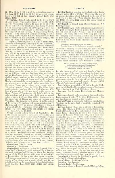
COVINGTON
N J N to SE by E J E, it ig of the natural appearance ;
but from SE by E J E to SE J S, it has a red colour.
See pp. 323-337 of Jas. Brown's Mound Table Club
(Elgin, 1S73).
Covington, a hamlet and a parish in the Upper "Ward
of Lanarkshire. The hamlet stands between the Clyde
and the Caledonian railway, 1J mile N by E of its
station and post-town Thankerton, this being 33J miles
SW of Edinburgh and 36$ SE of Glasgow ; at it is the
parish church (230 sittings), an old building enlarged in
the early part of last century. A neighbouring tower,
built in 1442 by Lindsay of Covington barony, is now a
fine ruin ; and Covington Mill was the place where that
famous martyr of the Covenant, Donald Cargill, was
seized by Irving of Bonshaw in May 1681.
The parish, containing also the villages of Thankerton,
Newtown of Covington (7 furlongs NNE of Thankerton),
and Hillhead (f mile NNE of the church), comprises
the ancient parishes of Covington and Thankerton,
united some time between 1702 and 1720. Bounded
N¥ by Pettinain, E by Libberton, SE by Syming-
ton, and W by Carmichael, it has an utmost length
of 5 miles from NNE to SSW, viz., from the Clyde
below Brown Ford to the top of Tinto ; its greatest
breadth, from E to W, is 2§ miles ; and its area is
5167J acres, of which 53 are water. The Clyde, here
winding 3f miles west-north-westward and northward,
roughly traces all the boundary with Libberton ; and
three or four burns run to it through the interior or on
the borders of the parish. In the extreme NE the sur-
face sinks to 630 feet above sea-level, thence rising to
829 at HUlhead, 1019 near Wellbrae, 1013 at Chester,
661 at Thankerton bridge, and 2335 on Tinto ; it is
divided among meadows or low well-cultivated fields
along the Clyde, pastoral slopes, and heathy uplands.
Nearly two-fifths of the entire area are under the plough,
and about 80 acres are in wood. Other antiquities than
Covington Tower are a cairn, three camps, and a
'Druidical temple.' Here, in 1S28, his father being
parish minister, was born the late Lord Advocate, Wil-
liam "Watson, who in 1880 was raised to the peerage as
Baron Watson of Thankerton. .St John's Kirk is the
only mansion : and 2 proprietors hold each an annual
value of more, 2 of less, than £500. Covington is in
the presbytery of Biggar and synod of Lothian and
Tweeddale ; the living is worth £265. A public school
at Newtown of Covington, with accommodation for 70
children, had (1S80) an average attendance of 44, and
a grant of £48, 3s. Valuation (1SS2) £64S7, 9s. Pop.
(1801) 456, (1831) 521, (1861) 532, (1871) 454, (18S1)
444.— Orel. Sur., sh. 23, 1865.
Cowal, the mid eastern district of Argyllshire. Its
north-western extremity is an isthmus between the head
of Loch Fyne and the boundary with Perthshire ; whilst
its north-eastern is a range of mountains along the
boundary with Perth and Dumbarton shires, to the
head of Loch Long ; and all the rest is a peninsula
bounded E by Loch Long and the Firth of Clyde, S by
the Kyles of Bute, and W by Loch Fyne. Its length,
from the head of Glen Fyne on the NNE to Lamont
Point on the SSW, is 37 miles ; and its greatest breadth
is 16J miles. It comprehends the parishes of Lochgoil-
head and Kilmorieh, Dunoon and Kilmun, Strachurand
Stralachlan, Inverchaolain, Kilmodan, and Kilfinan, and
the quoad sacra parishes of Ardentinny, Inellan, Kirn,
and Sandbank, with the chapelries of Strone, Toward,
Kilbride, and Tighnabruaich. See Argyllshire.
Cowcaddens. See Glasgow.
Cowdailly. See Cowthally.
Cowdenbeath, a village in the S of Beath parish, Fife, 2
miles WS W of Lochgelly, and 3 furlongs N by "W of Cow-
denbeath station on the Edinburgh, Perth, and Dundee
section of the North British, this being 5£ miles ENE
of Dunfermline. It has a post office under Lochgelly,
with money order, savings' bank, and telegraph depart-
ments, a Free church, and a public school ; and in the
neighbourhood are the extensive collieries of the Cowden-
beath Coal Co. Pop. (1861) 114S, (1871) 1457, (1881)
2712.
COWPITS
Cowden Castle, a mansion in Muckart parish, Perth-
shire, 2J miles ENE of Dollar. Occupying the site of
an ancient fortalice, which belonged to the see of St
Andrews, it is the seat of John Christie, Esq. (b. 1824 ;
sue. 1859), who owns 1672 acres in the shire, valued at
£1625 per annum.
Cowdenhill, a hamlet near Borrowstounness, N"W
Linlithgowshire.
Cowdenknowes, an estate, with a mansion, part ancient
and part modern, in Earlston parish, Berwickshire, on
the left bank of Leader Water, 1 mile S of Earlston
village. Its strong old tower, with deep pit beneath
and ' hanging tree ' outside (the latter cut down barely
50 years since), was the seat of those ancestors of the
Earls of Home whose feudal cruelties called forth the
malediction —
' Vengeance ! vengeance ! when and where?
Upon the house of Cowdenknowes, now and ever mair.'
Their estate has long been alienated, and now is held by
William Cotesworth, Esq. (b. 1827), who owns 2331
acres in Berwick and Roxburgh shires, valued at £2702
per annum. Behind the house rises Earlston Black
Hill (1031 feet), a picturesque conical eminence, crowned
with remains of a Roman camp. All know the plaintive
ah- and one at least of the three versions of the ballad —
' " O the broom, and the honny, bonny broom,
And the broom of the Cowdenknowes,"
And aye sae sweet as the lassie sang
1' the bught, milking the ewes.'
But the broorn-sprmkled braes and haughs of Cowden-
knowes — ' one of the most classical and far-famed spots
in Scotland' — had been sadly stripped of their golden
adornments by the so-called march of agricultural im-
provement, when, in the winter of 1861-62, the hand of
Nature nipped what man had spared. See pp. 133-137
of Lauder's Scottish Rivers (ed. 1874).
Cowey's Linn, a waterfall of 35 feet in leap in Eddie-
stone parish, Peeblesshire, on a head-stream of Eddlestone
W T ater, 3 miles N by W of Eddlestone village.
Cowgate. See Dundee, Edinburgh, and Mauch-
line.
Cowglen, a hamlet and a mansion in Eastwood parish,
Renfrewshire, 2 miles W by S of Pollokshaws. Coal
and limestone are worked in the vicinity.
Cowhill Tower, a mansion in Holywood parish, Dum-
friesshire, on the right bank of the Nith, 4| miles NNW
of Dumfries.
Cowie, a fishing village and a stream of Kincardine-
shire. The village, in Fetteresso parish, stands on the
N side of Stonehaven Bay, and | mile N by E of Stone-
haven town. Anciently it was a free burgh, under
charter of Malcolm Ceannmor, who, on a rock over-
looking the sea, is said to have built a small fortalice —
the Castle of Cowie. Of this some vestiges remain,
while its First Pointed chapel, which afterwards be-
longed to Marischal College, Aberdeen, is a picturesque
ruin, with a burying-ground still in use. Cowie House,
hard by, is a seat of Alex. Innes, Esq. of Raemoir (b.
1812 ; sue. 1S63), who owns 4750 acres in the shire,
valued at £2S47 per annum. Cowie Water, rising on
the western border of Glenbervie parish at 1000 feet
above sea-level, winds 13 miles eastward through the
rocky and wooded scenery of Glenbervie and Fetteresso
parishes, and at Stonehaven falls into Stonehaven Bay.
It is fairly stocked with small trout ; is subject to high
freshets, which often do considerable damage ; and is
crossed, J mile NNW of Stonehaven, by the grand
fourteen-arched Glenury Viaduct of the Aberdeen rail-
way, which, in one part 190 feet high, commands a fine
view of the river's ravine, the vale and town of Stone-
haven, Dunnottar Castle, and other features of the sur-
rounding landscape. — Orel. Sur., sirs. 66, 67, 1871.
Cowiefauld, a hamlet in Strathmiglo parish, Fife, 2
miles WSW T of Strathmiglo village.
Cowie's Linn. See Cowey's Linn.
Cowlairs. See Glasgow.
Cowlatt, Loch. See Coulatt.
Cowpits, a village in Inveresk parish, Edinburghshire,
Set display mode to: Large image | Transcription
Images and transcriptions on this page, including medium image downloads, may be used under the Creative Commons Attribution 4.0 International Licence unless otherwise stated. ![]()
| Gazetteers of Scotland, 1803-1901 > Ordnance gazetteer of Scotland > Volume 2 > (35) Page 291 |
|---|
| Permanent URL | https://digital.nls.uk/97373198 |
|---|
| Attribution and copyright: |
|
|---|---|

