Gazetteer of Scotland
(434) Page 424
Download files
Complete book:
Individual page:
Thumbnail gallery: Grid view | List view

STI
424
STI
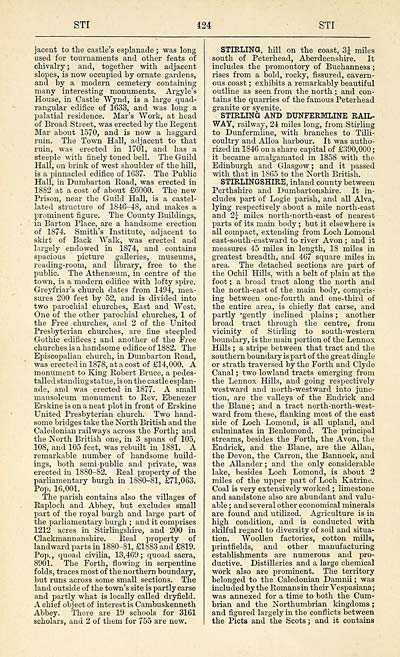
jacent to the castle's esplanade ; was long
used for tournaments and other feats of
chivalry; and, together with adjacent
slopes, is now occupied by ornate gardens,
and by a modern cemetery containing
many interesting monuments. Argyle's
House, in Castle "Wynd, is a large quad-
rangular edifice of 1633, and was long a
palatial residence. Mar's Work, at head
of Broad Street, was erected by the Regent
Mar about 1570, and is now a haggard
ruin. The Town Hall, adjacent to that
ruin, was erected in 1701, and has a
steeple with finely toned bell. The Guild
Hall, on brink of west shoulder of the hill,
is a pinnacled edifice of 1637. The Public
Hall, in Dumbarton Road, was erected in
1882 at a cost of about £6000. The new
Prison, near the Guild Hall, is a castel-
lated structure of 1816-48, and makes a
prominent figure. The County Buildings,
in Barton Place, are a handsome erection
of 1874. Smith's Institute, adjacent to
skirt of Back Walk, was erected and
largely endowed in 1874, and contains
spacious picture galleries, museums,
reading-room, and library, free to the
public. The Athenseum, in centre of the
town, is a modern edifice with lofty spire.
Greyfriar's church dates from 1494, mea-
sures 200 feet by 52, and is divided into
two parochial churches, East and West.
One of the other parochial churches, 1 of
the Free churches, and 2 of the United
Presbyterian churches, are fine steepled
Gothic edifices ; and another of the Free
churches is a handsome edifice of 1882. The
Episcopalian church, in Dumbarton Eoad,
was erected in 1878, at a cost of £14,000. A
monument to King Robert Bruce, a pedes-
talled standing statue, is on the castle esplan-
ade, and was erected in 1877. A small
mausoleum monument to Rev. Ebenezer
Erskine is on a neat plot in front of Erskine
United Presbyterian church. Two hand-
some bridges take the North British and the
Caledonian railways across the Forth; and
the North British one, in 3 spans of 105,
108, and 105 feet, was rebuilt in 1881. A
remarkable number of handsome build-
ings, both semi-public and private, was
erected in 1880-82. Real property of the
parliamentary burgh in 1880-81, £71,063.
Pop. 16,001.
The parish contains also the villages of
Raploch and Abbey, but excludes small
part of the royal burgh and large part of
the parliamentary burgh ; and it comprises
1212 acres in Stirlingshire, and 200 in
Clackmannanshire. Real property of
landward parts in 1880-81, £1883 and £819.
Pop., quoad civilia, 13,469; quoad sacra,
8901. The Forth, flowing in serpentine
folds, traces most of the northern boundary,
but runs across some small sections. The
land outside of the town's site is partly carse
and partly what is locally called dryfield.
A chief object of interest is Cambuskenneth
Abbey. There are 19 schools for 3161
scholars, and 2 of them for 755 are new.
STIRLING, hill on the coast, 3J miles
south of Peterhead, Aberdeenshire. It
includes the promontory of Buchanness ;
rises from a bold, rocky, fissured, cavern-
ous coast ; exhibits a remarkably beautiful
outline as seen from the north ; and con-
tains the quarries of the famous Peterhead
granite or syenite.
STIRLING AND DUNFERMLINE RAIL-
WAY, railway, 24 miles long, from Stirling
to Dunfermline, with branches to Tilli-
coultry and Alloa harbour. It was autho-
rized in 1846 on a share capital of £390,000 ;
it became amalgamated in 1858 with the
Edinburgh and Glasgow ; and it passed
with that in 1865 to the North British.
STIRLINGSHIRE, inland county between
Perthshire and Dumbartonshire. It in-
cludes part of Logie parish, and all Alva,
lying respectively about a mile north-east
and 2J miles north-north-east of nearest
parts of its mam body ; but it elsewhere is
all compact, extending from Loch Lomond
east-south-eastward to river Avon ; and it
measures 45 miles in length, 18 miles in
greatest breadth, and 467 square miles in
area. The detached sections are part of
the Ochil Hills, with a belt of plain at the
foot ; a broad tract along the north and
the north-east of the main body, compris-
ing between one-fourth and one-third of
the entire area, is chiefly flat carse, and
partly "gently inclined plains ; another
broad tract through the centre, from
vicinity of Stirling to south-western
boundary, is the main portion of the Lennox
Hills ; a stripe between that tract and the
southern boundary is part of the great dingle
or strath traversed by the Forth and Clyde
Canal ; two lowland tracts emerging from
the Lennox Hills, and going resrjectively
westward and north-westward into junc-
tion, are the valleys of the Endrick and
the Blane ; and a tract north-north-west-
ward from these, flanking most of the east
side of Loch Lomond, is all upland, and
culminates in Benlomond. The principal
streams, besides the Forth, the Avon, the
Endrick, and the Blane, are the Allan,
the Devon, the Carron, the Bannock, and
the Allander ; and the only considerable
lake, besides Loch Lomond, is about 2
miles of the upper part of Loch Katrine.
Coal is very extensively worked ; limestone
and sandstone also are abundant and valu-
able ; and several other economical minerals
are found and utilized. Agriculture is in
high condition, and is conducted with
skilful regard to diversity of soil and situa-
tion. Woollen factories, cotton mills,
printfields, and other manufacturing
establishments are numerous and pro-
ductive. Distilleries and a large chemical
work also are prominent. The territory
belonged to the Caledonian Damnii ; was
included by the Romans in their Vespasiana;
was annexed for a time to both the Cum-
brian and the Northumbrian kingdoms ;
and figured largely in the conflicts between
the Picts and the Scots ; and it contains
Set display mode to: Large image | Transcription
Images and transcriptions on this page, including medium image downloads, may be used under the Creative Commons Attribution 4.0 International Licence unless otherwise stated. ![]()
| Gazetteers of Scotland, 1803-1901 > Gazetteer of Scotland > (434) Page 424 |
|---|
| Permanent URL | https://digital.nls.uk/97360429 |
|---|

