Gazetteer of Scotland
(102) Page 92
Download files
Complete book:
Individual page:
Thumbnail gallery: Grid view | List view

CLY
92
COA
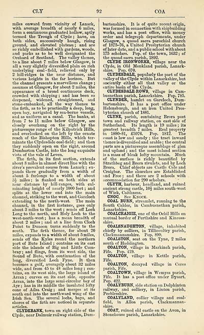
miles onward from vicinity of Lanark,
with average breadth of nearly 6 miles,
form a continuous graduated hollow, aptly
termed the Trough of Clyde ; have, on
both sides, successively haugh, rising
ground, and elevated plateau ; and are
so richly embellished with gardens, woods,
and parks as to be well designated the
Orchard of Scotland. The valley thence,
to a line about 7 miles below Glasgow, is
all a very slightly diversified plain on rich
underlying coal-field, relieved only by
2 hill-ridges in the near distance, and
various heights in the far horizon. But
the channel presents a marvellous change ;
assumes at Glasgow, for about 2 miles, the
appearance of a broad continuous dock,
crowded with shipping ; and has been so
deepened, widened, straightened, and
stone-embanked, all the way thence to
the firth, as to be practically a deep, long,
open bay, navigated by sea-borne vessels,
and as uniform as a canal. The banks, at
from 7 to 11 miles below Glasgow, are
closely overhung on the right by the
picturesque range of the Kilpatrick Hills,
and overlooked on the left by the ornate
reach of the Bishopton Hills, wbich ter-
minate the Clydesdale coal-field ; and then
they suddenly open on the right, around
Dumbarton Castle, into the long exquisite
vista of the vale of Leven.
The firth, in its first section, extends
about 8 miles in almost direct line with the
river's prevalent course from Lanark ; ex-
pands there gradually from a width of
about 5 furlongs to a width of about
3J miles ; is flanked on both sides at
near distance by hill-ranges, with cul-
minating height of nearly 1000 feet ; and
splits at the lower end into the main
channel, striking to the west, and Gareloch
extending to the north-west. The main
channel, in the first instance, goes only
about 3 miles to the west ; sends off Loch
Long to the north, and Holy Loch to the
west-north-west ; has a mean breadth of
about 2 miles ; and at a line from Cloch
Point to Dunoon turns suddenly to the
south. The firth thence, for about 20
miles, expands to a width of about 5 miles,
sends off the Kyles round the northern
part of Bute Island ; contains on its east
side the islands of Big and Little Cum-
bray; and flings, from its west side, the
Sound of Bute, with continuation of the
long, diversified Loch Fyne. It then
becomes a gulf, averagely about 32 miles
wide, and from 45 to 48 miles long ; con-
tains, on its west side, the large island of
Arran ; curves on its east side, opposite
Arran, into the large semi-circular bay of
Ayr ; has in its middle the insulated lofty
cone of Ailsa Craig ; and merges at its
south end into the northward wing of the
Irish Sea. The several lochs, bays, and
shores of the firth are noticed in separate
CLYDEBANK, town on right side of the
Clyde, near Dalmuir railway station, Dum-
bartonshire. It is of quite recent origin,
was formed in connection with shipbuilding
works, and has a post office, with money
order and telegraph departments, under
Glasgow, a quoad sacra parochial church
of 1875-76, a United Presbyterian church
of later date, and a public school with about
175 scholars. Pop. of the town, 1632 ; of
the quoad sacra parish, 2892.
CLYDE IRONWORKS, village near the
Clyde, in Old Monkland parish, Lanark-
shire. Pop. 670.
CLYDESDALE, popularly the part of the
valley of the Clyde within Lanarkshire, but
anciently either all that valley or the
entire basin of the Clyde.
CLYDESDALE-ROWS, village in Cam-
busnethan parish, Lanarkshire. Pop. 785.
CLYNDER, hamlet on Gareloch, Dum-
bartonshire. It has a post office under
Helensburgh, and an iron United Pres-
byterian church of 1881.
CLYNE, parish, containing Brora post
town and railway station, on east side of
Sutherland. Its length is 19 miles ; its
greatest breadth 7 miles. Real property
in 1880-81, £5976. Pop. 1812. The
coast is low and sandy ; the tract inward
thence is diversified and arable ; the central
parts are a picturesque assemblage of glen
and upland ; and the most inland section
is a mass of bleak lofty mountain. Much
of the surface is richly beautified by
Strathbeg and Brora rivulets, and by Loch
Brora. Chief objects are Castle Cole and
Craigbar. The churches are Established
and Free ; and there are 2 schools with
accommodation for 290 scholars.
CLYTH, harbour, headland, and ruined
ancient strong castle, lOJ miles south-west
of "Wick, Caithness.
CNOC. See Knock.
COAL BURN, streamlet, running to the
South Calder, in Cambusnethan parish,
COALCRAIGIE, one of the Ochil Hills on
mutual border of Perthshire and Kinross-
shire.
COALSNAUGHTON, village, inhabited
chiefly by colliers, in Tillicoultry parish,
Clackmannanshire. Pop. 899.
COALSTON, seat on the Tyne, 2 miles
south of Haddington.
COALTON, village in Markinch parish,
Fife. Pop. 419.
COALTON, village in Kettle parish,
Fife.
COALTON, decayed village in Ceres
parish, Fife.
COALTOWN, village in Wemyss parish,
Fife. It has a post office under Dysart.
Pop. 422.
COALYBURN, side station on Dolphinton
railway, and colliery, in Linton parish,
Peeblesshire.
COALYLAND, collier village and coal-
field, in Alloa parish, Clackmannan-
shire.
COAT, rained old castle on the Avon, in
Stonehouse parish, Lanarkshire.
Set display mode to: Large image | Transcription
Images and transcriptions on this page, including medium image downloads, may be used under the Creative Commons Attribution 4.0 International Licence unless otherwise stated. ![]()
| Gazetteers of Scotland, 1803-1901 > Gazetteer of Scotland > (102) Page 92 |
|---|
| Permanent URL | https://digital.nls.uk/97356445 |
|---|

