

Download files
Complete book:
Individual page:
Thumbnail gallery: Grid view | List view
©•^ ^' *^ — -^ — _-2_!l -^@
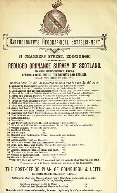
31 CHAMBERS STREET, EDINBURGH.
REDUCED ORDNANCE SURVEY OF SCOTLAND.
By JOHN BARTHOLOMEW, F.R.G.S.
SPECIALLY CONSTRUCTED FOR TOURISTS AND CYCLISTS.
SCALE— TWO MILES TO THE INCH.
In cloth case, 2s. 6d., or mounted on cloth and in case, 3s. 6d. each.
1. Edinburgh District (North Berwick to Stirling, and Kirkcaldy to Peebles).
2. Glasgow District (Coatbridge to Ardrishaig, and Lochgoilhead to Irvine).
3. Locll Lomond and Trosachs District (Dollar to Loch Long, and Loch Earn to Glasgow).
4. Central PertllSlllre District (Perth to Tyndrum, and Loch Tummel to Dunblane).
5. Perth and Dundee District (Glen Shee to Kinross, and Montrose to Pitlochry).
J&. Aberdeen District (Aberdeen to Braemar, and Tomintoul to Brechin).
7. Upper Spey and Braemar District (Braemar to Glen Roy, and Nethy Bridge to Killiecrankie).
8. Caithness District (whole of Caithness and east portion of Sutherland).
9. Oban and Loch Awe District (Moor of Rannoch to Tobermory, and Loch Eil to Arrochar),
10. Arran and Lower Clyde District (Ayr to Mull of Cantyre, and Millport to Girvan).
11. Peterhead and Banff District (Peterhead to Fochabers, and the Coast to Kintore).
12. Inverness and Nairn District (Fochabers to Strathpeflfer, and Dornoch Firth to Grantown).
13. Fort William District (Loch Duich to Loch Ericht, and Strath Afiiric to Ben Nevis).
14. Sutherlandshlre.
15. Ross-shire.
16. Ayr District (Ballantrae to Thornhill, and Irvine to New Galloway).
17. Hawick and Moffat District (Dumfries to Cheviot Hills, and Melrose to Canobie).
18. Orkney Islands. Coloured to show parishes.
19. Shetland Islands. do.
20. Isle of Skye. do.
21. Berwick and Haddington Shires. Coloured to show parishes.
22. Forfarshire. do.
23. Lewis and Harris (Outer Hebrides). do.
24. North and South Uist and Barra (Outer Hebrides).
25. Mull, Coll, Tiree, and Staffa. Coloured to show roads and relief of land.
26. Islay, Jura, and Colonsay. do.
27. Arisaig, Moidart, Glenelg, Rum, and Elgg. do.
28. Wigtown and Stranraer District. do.
29. County of Kirkcudbright. Coloured to show parishes.
30. Coimty of Dumfries. do.
TOURIST'S MAP OF SCOTLAND, coloured into contours to show the relief of land.
Published by A. & C. Black, Edinburgh, and Sold by all Booksellers.
THE POST-OFFICE PLAN OF EDINBURGH & LEITH,
By JOHN BARTHOLOMEW, F.R.G.S.
Extended to show new Municipal and Police Boundary/, and brought up to datt,
May he had in the following forms : —
In Sheet, plain or folded in Cover . . .Is.
Coloured into Municipal Wards or Parishes . . 2b.
Mounted on cloth rollers and varnished, 2s. extra. Copies may he had printed on thicker paper.
Set display mode to: Large image | Transcription
Images and transcriptions on this page, including medium image downloads, may be used under the Creative Commons Attribution 4.0 International Licence unless otherwise stated. ![]()
| Scottish Post Office Directories > Towns > Edinburgh > Post Office Edinburgh and Leith directory > 1886-1887 > (12) |
|---|
| Permanent URL | https://digital.nls.uk/83628932 |
|---|
| Description | Post-Office Edinburgh & Leith directory 1886-87 |
|---|---|
| Shelfmark | POE |
| Additional NLS resources: | |
| Attribution and copyright: |
|
| Description | Edinburgh : Postmaster General, [1846-1975]. Preceded by: Edinburgh & Leith Post Office Directory Limited. |
|---|---|
| Shelfmark | Various |
| Description | Directories of individual Scottish towns and their suburbs. |
|---|
| Description | Around 700 Scottish directories published annually by the Post Office or private publishers between 1773 and 1911. Most of Scotland covered, with a focus on Edinburgh, Glasgow, Dundee and Aberdeen. Most volumes include a general directory (A-Z by surname), street directory (A-Z by street) and trade directory (A-Z by trade). |
|---|