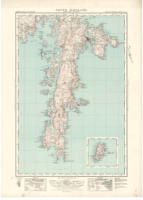
(4) Sheet 4 - South Mainland (Shetland Islands)
Thumbnail gallery: Grid view | List view
Set display mode to: Large image | Zoom image
Images and transcriptions on this page, including medium image downloads, may be used under the Creative Commons Attribution 4.0 International Licence unless otherwise stated. ![]()
| Ordnance Survey One-Inch Popular edition of Scotland - 1921-1930 > (4) Sheet 4 - South Mainland (Shetland Islands) |
|---|
| Permanent URL | https://digital.nls.uk/74584338 |
|---|---|
| Description | Sheet 4 of the Ordnance Survey One-inch Popular Edition of Scotland. It was issued in 1932 at a scale of 1 inch to 1 mile (1: 63,360) from a survey done between 1928 and 1929. The first Ordnance Survey of this area was done between 1877 and 1878. This sheet shows the southern part of Mainland in Shetland, the long peninsular which stretches south from Dales Voe and Lax Firth to end at the promontories of Sumburgh Head and Fitful Head. In the north, the island of Bressay lies off the east coast, separated from Mainland by the Sound of Bressay. The capital of the Shetlands, Lerwick, is situated on Mainland opposite Bressay. On the right, the sheet stretches, in the north, from a point in the North Atlantic approximately 60 degrees 13 minutes north, and 55 minutes west, north and east of Bressay, to, in the south, a point in the North Atlantic approximately 59 degrees and 49 minutes north, and 55 minutes west. On the left, the sheet stretches, from Olas Voe, in the north, to, in the south, a point in the North Atlantic 59 degrees and 49 minutes north, and 1 degree 30 minutes west. The Fair Isle, which is situated in the North Atlantic 25 miles south and west of the Shetlands, is inset on the lower right side of the sheet. There are two sets of References, the scale statement ‘One Inch to One Statute Mile - 1/63360’, with accompanying scale bar, and two further scale bars of 1 centimetre to 1000 yards and 1 centimetre to 1 kilometre. Contours and fathoms are shown, with accompanying information about measurement. Fair Isle is famed for its knitwear of intricate coloured designs. According to Groome's 'Gazetteer of Scotland' (1894), these designs were taught to the islanders 'by the 200 Spaniards who escaped from the wreck at Stromceiler Creek of the flagship of the Duke de Medina Sidonia, the Admiral of the Spanish Armada, when retreating in 1588 before the English Squadron'. |
| Description | A series of 92 sheets mapping all of Scotland. Ordnance Survey aimed to produce an attractive contoured road map that would be popular with the 'man in the street'. The ‘Popular’ edition was particularly intended for the inter-war generation's leisure hours – cycling, touring or walking through the countryside. |
|---|---|
| Shelfmark | Map Room |
| Additional NLS resources: |
|