Maps in directories
Drawn for the directories
You can find maps, or town plans, in some of the directories for:
- Aberdeen
- Dundee
- Edinburgh
- Glasgow
- Greenock
- Paisley
- Perth
- Portobello.
These were drawn specifically for the directories and as a result they would cover the same geographical area as the alphabetical lists within the directories.
Being up-to-date
Depending on the map-maker, time period, and production process, the town plans would be more or less up-to-date with town developments.
Around 1800, a delay of about two to three years would be normal, whereas by 1900 town plans could depict latest changes within six months.
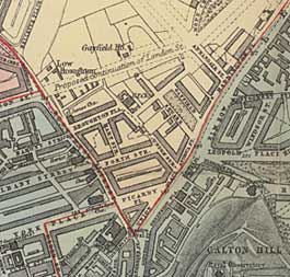
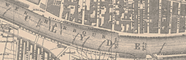
Some maps digitised
National Library of Scotland has digitised a selection of these town plans, available on the NLS maps website:
- Plan of Aberdeen, 1888
- Plan of Glasgow with suburbs, 1882
- Plan of Glasgow with suburbs, 1888
- 'The strangers guide' Edinburgh and Leith plan, 1805
- Hislop's plan of Edinburgh and Leith, 1865
- Plan of Edinburgh and Leith with suburbs, 1882
- Johnstons' plan of Edinburgh, Leith, Portobello and environs, 1888
- Plan of Edinburgh and Leith with suburbs, 1888-1889
-
Plan of Edinburgh and Leith with suburbs, 1891-1892
-
Plan of Edinburgh and Leith, 1893-1894
- Bartholomew's plan of Edinburgh and Leith with suburbs, 1901-1902
- Plan of Edinburgh, Leith and Portobello with suburbs, 1905-1906
- Bartholomew's Plan of Edinburgh and Leith with suburbs, 1907
- Plan of Edinburgh, Leith, and Portobello with suburbs, 1910-1911
More digitised town plans
NLS digital maps include many other town plans as well. Although they were not explicitly drawn for the directories, they might still be a valuable resource for your research:
Browse NLS town plans from 1580-1919 ![]()